The First Five: A Brief Overview of the First Reclamation ProjectsThe First Five: A Brief Overview of the First Reclamation Projects
While Frederick Jackson Turner might have declared that the frontier was at an end in 1893,
countless lands within the American West had not yet been reclaimed or made productive. In the last
quarter of the nineteenth century, the federal government surveyed the country in the western states
and territories, examining potential diversion and storage sites while calculating irrigable acreage.
The U.S. Geological Survey estimated that 30 million acres could be irrigated, but by 1890, only 3.6
million acres were being farmed. Because of the vision of certain individuals who knew that for America
to reclaim its arid Western lands required the involvement of the national government, the fertile
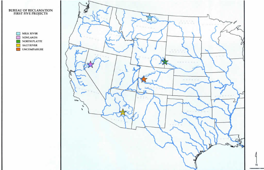
acreage in the Salt River Valley in Central Arizona, the lands in western Nevada, the valley of the
North Platte River in Nebraska and Wyoming, the farmers along the Milk River situated in northeastern
Montana, and the region along the Uncompahgre River in Colorado, would have the necessary water to
promote and sustain growth. This is a brief overview of the first five projects authorized by the
Secretary of the Interior under the National Reclamation Act from their beginning, to their place
today in the settlement of the West. John Wesley Powell, Civil War general, explorer of the Grand Canyon, surveyor of Western lands,
and head of the U.S. Geological Survey, believed that the federal government should reserve lands for
the small family farmer and assist in the development of irrigation projects. Powell wanted the settlement
of the West to be in the hands of the individual homesteader even though it would require support by
Washington, yet not all the lands were still available; land speculators claimed much of the potentially
good farm acreage. But neither the early small landowning farmer, nor the land developer, or the eastern
entrepreneurs, had the necessary resources to finance the construction of dams to store additional water
to reclaim the western lands. In his report on arid lands, Powell wrote that he considered the character
of the lands themselves, the engineering problems, and suggested, "legislative action necessary to
inaugurate the enterprises by which these lands may eventually be rescued from their present worthless
state."[1]
Promoters of western irrigation, including the influential National Irrigation Congress, maintained
that the federal government should be involved in developing the arid lands. George Maxwell, a leading
spokesman for the national irrigation movement and a believer that settlement of western lands by yeoman
farmers would solve the social ills of the eastern urban centers with the movement of the population,
met with Frederick Newell, chief hydrographer with the U. S. Geological Survey. Newell, a protege of
John Wesley Powell, surveyed the arid lands of the West and understood the plight of the homesteader who
could not get enough water to irrigation his lands and grow crops to support his family. Maxwell and
Newell met frequently with Wyoming Senator Francis E. Warren and Nevada Congressman Francis G. Newlands
to devise a plan so that the government could sponsor federally funded water projects.[2]
At the turn of the century many in Congress realized that without the support of the national
government, settlement of additional lands in the West would not be possible; various congressman supported
a reclamation act which would provide federal monies to construct irrigation works and further the
development of the arid lands. Yet, it was not until after the assassination of President William McKinley
and the ascendency of Theodore Roosevelt to the presidency did Congress enact the National Reclamation Act.
The statute, by authorizing the use of federal money from the sale of public lands, would make extensive
areas of the West suitable for irrigation, provide homes for America's citizens, increase the agricultural
production of the nation, and "make beneficial use of two of its national assets, land and water."[3]
Although the National Reclamation Act was not signed until June 17, 1902, the engineers prior to
its passage had already investigated the Western landscape for potential dam sites and irrigable farm
lands. After the measure's enactment, the engineers of the U. S. Geological Survey and then the newly
created U. S. Reclamation Service prepared a list of potential projects for the Secretary of the Interior
to authorize. The Reclamation Service considered certain criteria, such as water supply, storage facilities,
alignment of canals, and selection of feasible lands. While the engineers usually required several years
of study to make these necessary determinations, the western settlers were eager to begin the work of
reclaiming the land and wanted projects announced as soon as possible. The Reclamation Service, aware of the current circumstances, recommended certain projects that
could be clearly defined with the costs and results estimated. As early as 1889, John Wesley Powell had
explored the arid lands of the West, noting potential storage dam sites and the fertility of the land.
Fellow geological engineer and later official in the Reclamation Service, Arthur P. Davis surveyed the
land in the West by the turn of the century. With this background in place, it would not take long for
the first projects to be selected by the Secretary of the Interior. On March 7, 1903, Charles D. Walcott, Director of the U. S. Geological Survey recommended the
first five projects to the Secretary of the Interior: Sweetwater (North Platte) situated in Wyoming and
Nebraska, Milk River in Montana, Truckee (Newlands) in Nevada, Gunnison (Uncompahgre) located in Colorado,
and the Salt River Project in Central Arizona. On March 14, 1903, Secretary Ethan A. Hitchcock concurred
with the suggestions, stating that the Reclamation Service should concentrate its efforts upon these five
projects, secure the lands needed for the dams, reservoirs and appurtenant irrigation works, negotiate
with current owners of irrigable lands, and prepare contracts for the construction of the reclamation
works.[4]
Each project presented both unique conditions while being similar in other respects. All five
projects contained both private and public lands. A few projects had some irrigation works, while others
needed the construction of storage dams to provide the additional water supply as well as canals and ditches
to bring the water to the land. Towns and communities were created within the reclamation projects while
the opportunity for others to grow and become major cities became a reality. By examining individually the
first five projects, we can appreciate the impact of the National Reclamation Act on Western America.
TodayIn 1902, the authors of the National Reclamation Act provided a way for the settlers to support
their families and develop the West through farming. The first five reclamation projects encountered
varying degrees of success, but all managed to transform the land, some as originally intended, others
with certain limitations, and at least one changed a fertile agricultural valley into a major metropolitan
center that sparked the development of the whole state. While the men of the Newlands Project envisioned irrigating 200,000 acres at its inception, by 1970,
62,000 acres received project water. Today claims by others to the waters of the Truckee and Carson rivers
and Lake Tahoe, including land and water set aside for a wetlands project in Lahontan Valley and settlement
of water rights with the Pyramid Lake Indian Tribe, limited the amount available for farming. Despite the
water woes, the population has increased from under 1,000 people when the Newlands Project was authorized
to over 18,000 people living within the Project lands. The "businessman/farmer" has become a part-time
entrepreneur with more than 4,000 part-time farms averaging 13 acres, contributing approximately 35% of
the current economy in Churchill County with a total crop value of a little over $13 million in 1992. The
waters of the Newlands Project also support the growing recreational activities of camping, boating,
and fishing.[5]
Currently farmers irrigate approximately 70,000 acres on the Uncompahgre Project, more than double
the amount prior to its selection as a reclamation project, but less than the 130,000 acres planners
imagined could be cultivated. Following the transfer of the operation and maintenance of the project to
the Uncompahgre Valley Water Users' Association in 1932, additional irrigation works were constructed,
including the Taylor Park Dam to regulate the water for the Gunnison Tunnel. Crops grown today are
principally the same as when the project started except for sugar beets. In the 1960s, the farmers started
growing malt barley for the manufacture of beer by the Adolph Coors company. Today the population is closer
to 20,000, whereas a century ago, the region contained less than 5,000 residents.[6]
Farmers on the Milk River Project cultivate about 100,000 acres, certainly more than three
times the amount irrigated 100 years ago. Project lands, stretching 165 miles, are divided into the
Dodson Pumping Unit, and the Chinook, Malta, and Glasgow Divisions with individual irrigation districts
operating the transmission and distribution facilities and the Bureau of Reclamation retaining control
over the storage works. Like the Newlands Project, many of the current farm sizes provide income for
only a part-time living, while owners have jobs in the nearby cities. The irrigated acreage has remained
relatively stable in recent years, with ranching and farming the main industries on project lands.[7]
Urbanization has not been a factor on the Milk River Project, but other elements have influenced
this reclamation project. Over the years, changes in crops grown have impacted the neighboring communities.
Sugar beets, once a major crop that required a large labor force as well as producing feed for sheep, is no
longer grown on the project lands. The elimination of this crop had a trickle down effect - without the
sugar beets, the large number of migrant workers have not been needed and the sheep industry left the Milk
River area. Extreme weather conditions, ranging from 100 degrees in the summer to minus 40 degrees in the
winter, have also aided in the reduction of population on the Milk River Project. Farmers also have to
contend with endangered or threatened species issues in the future to keep their irrigation water. Recreation
is a major growth industry in the West and the creation of the Fresno and Nelson reservoirs and Lake Sherbume,
have provided a favorite venue for boaters and fishermen who can also enjoy the waters of this reclamation
project.[8]
Since a handful of mountain men began trapping the beaver, to the early immigrants looking for a
better life, to the rancher seeking grazing lands, to the farmer searching for the fertile acre and enough
water, the North Platte Project transformed the prairies to a part of America's farmland. At the turn of the
century, the population of Scotts Bluff County was less than 3,000 people, while today, in the city of
Scottsbluff alone, there are over 14,500 residents. With the North Platte Project, the irrigated acreage
increased from 3,000 acres to over 300,000 acres and encouraged the development of the sugar beet industry
worth over $47 million in 1991. Besides being a cash crop, sugar beets also provide feed for the traditional
western occupation of ranching; nearly a half a million head of cattle, sheep and hogs are raised on the
North Platte Project. Almost from its start, the waters of the North Platte have been a safe haven for
wildlife after President William Howard Taft created the Pathfinder National Wildlife Refuge. Project lakes
continue to provide a resting place for migratory fowl as well as a setting for recreational activities,
including boating and fishing.[9]
From its foundation of bringing water and power to its shareholders in the Salt River Valley, SRP has
become the largest raw water supplier in the Phoenix metropolitan area and the nation's third-largest public
power utility, delivering power to over 745,000 customers. Maricopa County is the major population center of
Arizona, increasing from 20,450 people in1900 to over 3 million in 2000. Phoenix, in the heart of the Salt
River Valley, is the county seat, the state capitol of Arizona, and now the 6th largest city in the United
States. For almost one hundred years, the Association has continued to provide water to over 300,000 acre member
and neighboring lands and has evolved into a multi-dimensional water service provider. Although only 44,000 acres
are still being farmed within the Project, SRP delivers water to urban irrigators and several municipalities who
treat the water and distribute it to SRP's urban shareholders. To this end, ten water treatment plants operated
by eight cities dot the SRP water system. SRP's stewardship of central Arizona's water supply has made it a leader in the management of water
resources, encompassing a wide range of activities. In partnership with several Valley cities, SRP jointly
owns and operates the Granite Reef Underground Storage Project (GRUSP), one of the largest recharge projects
in the United States. GRUSP stores Central Arizona Project water on behalf of the Arizona Water Banking
authority and others for use in the future when dry conditions will prevail. To assist various Valley entities,
SRP cooperated with the Bureau of Reclamation in the delivery of Central Arizona Project water with the
construction of the CAP/SRP Interconnect Facility near Granite Reef Dam. Operated by SRP, the interconnect
links the CAP canal with SRP's irrigation system, further allowing for the purchase of surplus Colorado River
water to meet the demands of our shareholders during times of water shortage as well as assist in water
exchanges. At the end of World War II, the Salt River Valley experienced a major explosion of growth which
impacted SRP's traditional farming community. The returning veterans wanted homes and agricultural lands
were sold for thousands of houses in the newly developed subdivisions. With increased urbanization, the
Association had to find new ways to operate and maintain its canal system. Under the Bureau of Reclamation's
Rehabilitation and Betterment Program, SRP started construction and implementation of the Supervisory Control
system in the late 1960s. The advances in electronic equipment allowed for the design of a water distribution
system covering 138 miles to be handled by a single operator. By the mid-1970s, computer equipment monitored
telemetered data which displayed water levels and gate positions. The dispatcher could regulate 331 radial
gates and almost one quarter of the deep-well pumps belonging to SRP. With this system, the water levels of
the canals and laterals could be maintained at a constant level. Gone are the days when bells rang at the
home of the gate operators to warn about pending trouble. Keeping pace with new technology allowed SRP to utilize the new water Supervisory Control and Data
Acquisition (SCADA) developed between 1989 and 1991. SCADA is a complex computer-based system which allows
remote control and monitoring of the entire water canal system, a major portion of the deep-well system, and
numerous sites of interest to water accounting concerns. The system remotely scans and operates over 120
sites on the canals and controls over twenty off-project flow and special-delivery sites and an ever-expanding
number of water quality monitoring stations throughout the system. With thousands of homes adjacent to the canals, SRP continues to maintain the physical appearance of its
irrigation facilities. No longer are sheep seen eating the grass along the canal banks or the Yaqui laborers
leading the horses in the ditches to eliminate the aquatic moss and weeds. In 1989, SRP instituted a program
of stocking its canals with white Amur, a sterile weed eating fish that originally came from China and is
considered an economically and environmentally safe alternative to chemical and mechanical weed control. SRP
crews trim the trees and remove brush and other vegetation along the canal banks, not only for its own
maintenance vehicles, but for the thousands of bicyclists, joggers, and horseback riders who use the paths
for recreation. As part of a program completed in 1989, SRP installed safety steps and ladders providing a
quick exist for stray animals and people who accidentally enter the canal system. From its inception at providing electricity for the construction of Roosevelt Dam, power generation
has been an integral part of the Salt River Project. The Association constructed its first hydropower plants
on the Valley canals between 1911 and 1913, expanding its production with the construction of three additional
dams, Mormon Flat, Horse Mesa, and Stewart Mountain, on the Salt River between 1923 and 1930. SRP had 49 power
customers in the 1920s, by 1947, it delivered electricity to over 12,000 customers and by 2003, its power should
be transmitted to close to 800,000. To meet this continually growing demand for electricity, SRP upgraded its transmission and
distribution systems over the years, converting from 25 cycle power to 60 cycle after World War II and
building non-hydropower plants. Within the Salt River Valley, SRP built several oil or natural gas
generating stations and participated in several coal-fired power plants in the southwest region, including
Mohave Generating Station and the Four Corners Power Plant. As part of the Central Arizona Project, SRP was
chosen as the construction manager and plant operator of the Navajo Generating Station near Page, Arizona,
participating with other utilities and the federal government. During the 1970s, SRP decided to construct
the coal-fired Coronado Generating Station alone, while being a partner in the Palo Verde Nuclear Generating
Station southwest of the Salt River Valley. In order to provide its customers with a reliable source of power
in the future, SRP is expanding its Valley generating stations and finding new and environmentally compatible
methods for the production of power, including landfill gasses and solar energy. From its inception to the
present day, Salt River Project has supplied both water and energy that helped fuel the growth of its
shareholders and central Arizona. SummaryThe passage of the National Reclamation Act heralded a new era in the development of the arid West.
While some might argue that the rhetoric of its passage is mythic, nonetheless, the act President Theodore
Roosevelt signed on June 17, 1902, transformed the West. Prior to their selection by Secretary of the
Interior Ethan A. Hitchcock as the first five reclamation projects, the lands in Nevada, Colorado, Montana,
Wyoming-Nebraska, and Arizona, were being farmed, but without a stable water supply, sustained growth could
not be achieved. The federal government, in the name of the Reclamation Service and later the Bureau of
Reclamation, provided the funding and the engineering expertise to construct the necessary storage works,
to allow for that development, whether in actual increased irrigated acreage, population, or economic value.
The success of the National Reclamation Act can be measured by the accomplishments of the Newlands,
Uncompahgre, Milk River, North Platte, and Salt River reclamation projects. John Wesley Powell surveyed the American West more than one hundred years ago and saw thirty million
acres that could be irrigated. Because of the vision of a few men and the Bureau of Reclamation, nine to
ten million acres are productive, whether growing crops, homes, communities or fueling industries. Reclamation
is the cornerstone of growth in the West: providing a stable water supply for crops, transforming the desert
to farmlands, and now farmlands to cities, businesses, and communities; producing electricity to operate the
irrigation pumps, light the homes, and now power our industries. Reclamation's objective hasn't ceased, but
instead becomes more fully developed: the foundation of growth in the American West. |
|
|