The early travelers crossing southern Arizona on their way to California followed the Gila River,
not usually proceeding up to the Salt River. But when the miners discovered bodies of ore along the
Hassayampa River and then the military came to keep the hostile Indians away, Jack Swilling found the
remains of prehistoric canals in what became the Salt River Valley. By the 1 870s other farmers and
settlers found the land along the Salt River to be fertile and stayed to cultivate the soil, growing
extensive fields of grain or alfalfa, or establishing commercial businesses, but within thirty years
the flow of the river was over appropriated and growth could not be maintained.
At least a half dozen companies constructed canals, most cooperative organizations of local
farmers who worked together to build the irrigation channels to deliver water to their own land. In
1883, the Arizona Canal Company sold bonds to investors around the country in order to construct the
Arizona Canal on the northern tier of the Salt River Valley. This canal company expected to make a
profit from the sale of land and water rights to new settlers and with its chief construction contractor,
W. J. Murphy, and original incorporator Clark Churchill, formed the Arizona Improvement Company. Sitting
on the first Board of Directors were local businessmen, Murphy, Churchill, and William Christy,
along with California and Nevada entrepreneurs, Frederick W. Sharon and Francis G. Newlands.[1]
W. J. Murphy and his family purchased several tracts of land under the Arizona Canal and started
an experimental citrus orchard with over 1,800 young orange and other fruit trees from southern
California. The trees proved so successful other varieties were planted including olive and lemon.
Because the Arizona fruit ripened prior to the orchards in Southern California, Arizona landowners
could sell their produce to the eastern markets first. By the mid-1890s over 150,000 citrus trees
were growing on 1,500 acres and farmers learned they could grow the trees with less acreage and work
than the traditional harvests of grain.[2]
W. J. Murphy built the Ingleside Club, complete with a golf course, near the Arizona Canal to
bring investors and potential landowners to the Salt River Valley. With the help of men like Murphy,
the population of the Salt River Valley doubled between 1890 and 1900, reaching almost 20,000
residents and irrigated acreage increased from 111,000 to 130,500 acres. By the turn of the century,
however, the landowners realized that a storage dam was needed on the upper Salt River for growth
to continue, but private enterprise could not provide the needed funding.[3]
Arizona's struggle for a permanent water supply moved to Washington, D.C. at the beginning of
the new century. Benjamin Fowler, chairman of the Maricopa County Water Storage Committee, had been
in the federal Capitol at various times since 1900, lobbying for passage of a bill to permit the
county to issue bonds for construction of a dam and then stayed to fight for a federal reclamation
act. Through the efforts of national reclamation lobbyist George Maxwell, Fowler, who later became
the first president of the Salt River Valley Water Users' Association, became well acquainted with
Frederick Newell and Gifford Pinchot, Chief Forester. Fowler offered the U.S. Geological Survey
$1,500 in matching funds to continue its earlier investigation of the Salt River, including a survey
of a damsite at the confluence of the Salt River and Tonto Creek. Maxwell moved to the nation's
Capitol, leasing a house near Newell to aid Francis Newlands in his congressional fight for a
reclamation act. At his Washington residence, Maxwell gathered Newell, Fowler, and Pinchot to
discuss the national irrigation movement and a possible Salt River Valley reclamation
project.[4]
Gifford Pinchot and George Maxwell were good friends with vice-president Theodore Roosevelt,
a strong supporter of the reclamation and conservation movements. Following the ascendency of
Roosevelt to the office of the President, the reclamation measure passed Congress and received
Roosevelt's signature. The Secretary of the Interior was authorized to choose the first projects
from a list supplied by Newell. The influence of Newell, Pinchot, and Maxwell, with Fowler's
organization in the Salt River Valley, made the Tonto project an attractive enterprise to the
federal government, although most of the land was in private ownership.
Within months of the passage of the reclamation act, engineers arrived in the Salt River
Valley to survey the lands and possible location of irrigation works. Prior to the construction of
what would become Theodore Roosevelt Dam, the engineers constructed a sixty-mile road through the
rugged Superstition Mountains and the canyons of the Salt River to bring supplies from railhead at
Mesa to the dam site. Building the "Apache Trail" would be one of the most dangerous tasks of the
dam construction process and in its first month of operation, over a million and one half pounds of
freight would be hauled over it. Louis C. Hill, the supervising Reclamation Engineer traveled the
Apache Trail while overseeing construction of the Roosevelt Dam. Built between 1905 and 1911, crews
laid stone from the neighboring canyon walls for the rubble-masonry thick-arch structure which
spanned the Salt River to an original height of 280 feet and crest length of 723 feet, holding back
over 1,300,000 feet of water. Stonemasons cut the upstream and downstream faces of the six to
ten-ton blocks which were laid in a stair step fashion, giving the dam its identifiable appearance.
President Theodore Roosevelt attended the dam's dedication, traveling over the Apache Trail,
on March 18, 1911.[5]
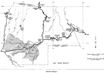
Flooding would delay construction at the dam site, but would also lead to the present
configuration of the Salt River Project. The Arizona Dam, just below the confluence of the Salt and
Verde rivers, diverted water to the north side canals, but was prone to damage by floods and in 1905,
a major flood swept down the Salt River. The Arizona Dam was washed away and the farmers north of the
Salt River approached Louis C. Hill for assistance. To unify the lands in the Salt River Valley, the
Reclamation Service constructed the 1,000 foot long Granite Reef Diversion Dam which diverts water
to both the north and south side canals. The federal government purchased many of the existing canals
within the Salt River Project boundaries and built additional ones to bring the waters of the Salt
and Verde rivers to 170,000 acres.
After prolonged conferences on irrigable acreage and repayment costs of the project, Secretary
of the Interior Franklin K. Lane signed over operational control of SRP to the Salt River Valley Water
Users' Association in 1917. Significantly, the September 6, 1917 agreement permitted the Association
to retain the power revenues generated at SRP facilities, thus allowing for its future growth.
Conceived by the Reclamation engineers as a source of electricity for construction of Roosevelt Dam,
power generation developed by a power canal and as part of the dam were in the drawings almost from
the initial plans. During the 1920s, Project management expanded its hydropower installations with
the construction of three additional dams on the Salt River and more lands joined the Association,
bringing its membership up to 242,000 acres.