As in most western territories, farming in the Montana region saw little activity until the 1860s,
although limited agriculture occurred earlier near the fur trading posts. The gold miners rushing to stake
and work their claims did not want or have the time to till the soil for vegetables and grains, requiring
the need of others to provide those commodities. Farmers soon came to cultivate the land and construct
small water delivery systems. Although the Milk River Valley in northeastern Montana receives approximately
20 inches of rainfall, irrigation was a necessity. The communities of Chinook and Harlem developed canal
systems with a communal diversion dam, as did the Bureau of Indian Affairs for the Assiniboine and Gros
Ventre tribes on the Fort Belknap Indian Reservation. By the turn of the century, farmers irrigated 35,000
acres, growing oats, vegetables and pasturage for livestock. But without a stable water supply, the economic
growth of the region could not be assured.[1]
Under the instructions of Frederick Newell, Geological Survey Engineer Gerard H. Matthews studied the
feasibility of diverting the water from the St. Mary River to the Milk River in 1900. The engineers determined
that with the construction of a gravity canal between the two rivers, it was possible to transport water from
one river to the other. Cyrus Babb continued the survey of the region, investigating various diversion points
and identifying what lands needed to be withdrawn. Eventual plans depended, however, on an agreement between
the governments of Canada and the United States, because the waters of the St. Mary River traveled through
Canada before returning to the United States. Although a treaty would not be reached for almost a decade, the
Reclamation Service suggested that the Milk River Project be among the first approved. The waters of the Milk
River Project also created problems within the continental United States when, as requested by the Reclamation
Service, a determination of water rights was set in motion in 1905. The U.S. Supreme Court, in deciding the
case of U S. v Winters in 1908, established the Indian and federal reserved rights doctrine, followed by
today's judicial system.
Although it is not clear why the Milk River Project was among the first chosen, the United States
government may have wanted to protect the water supply of the Milk River from overuse by the Canadian farmers
or possibly guarantee it as a stable source of water for the Indians on the Fort Belknap Reservation. In his
autobiography, Newell noted that the Milk River Project had "international complications," and like the other
first projects, he was instrumental in sending out the engineers to survey potential reservoir sites and
alignments for canals.[2]
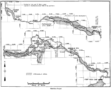
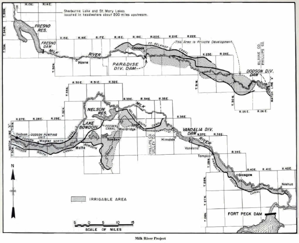
The Reclamation Service engineers designed a system of irrigation canals and dams which would
delivery water to the farmers for the irrigation of 120,000 acres. Beginning with the construction of
Lake Sherburne Dam, the stored water would be released into the St. Mary River before being diverted into
the twenty-nine mile long St. Mary Canal and then discharged into the Milk River. The water continues to
flow northward into Alberta, Canada before re entering the United States, traveling more than 200 miles
where it is stored in the Fresno Reservoir until it is needed by the farmers, proceeding through a
series of diversion dams having journeyed through 200 miles of canals, 219 miles of laterals, and
295 miles of drains.[3]
As construction of the engineering features continued through several decades, settlement of the
lands progressed slowly. Even though there was no formal opening of the Milk River Project by the Secretary
of the Interior for many years, the Reclamation Service allowed World War I veterans to file entries on the
public lands in 1920. During the next decade, landowners with large holdings were not eager to divide their
land into the smaller units as required by the Reclamation Act, hindered development on the Project. New
farmers also had a difficult time adjusting to the farming conditions and many left within the year after
planting their first crop. Those that remained produced good yields of grains, hardy vegetables, and alfalfa,
which supported the local livestock industry.[4]
Throughout the Montana drought of the late 1920s, and the Dust Bowl of the 1930s, the Milk River
Project acted as haven for those farmers who lost everything. The federal government assisted in relocating
the 'dry land farmers' who had tried to make a living in other parts of Montana and Texas and Oklahoma settlers
who saw their lands blown away. The Bureau of Reclamation still supported the small farmer with making a
living and settling the arid West.[5]