Ancient Machu Picchu Drainage EngineeringAncient Machu Picchu Drainage Engineering
ABSTRACT: The drainage infrastructure constructed by the Inca at ancient Machu Picchu represents a
significant public works achievement. The difficult site constraints associated with the nearly 2,000 mm
per year of rainfall, steep slopes, landslides, and inaccessibility posed drainage challenges that were
met successfully by the Inca. The technical analysis of the Inca drainage works demonstrates that the
drainage criteria used were reasonable and the implementation exceptional, and that the Inca were good
engineers even though they labored without the benefit of a written language or the use of a wheel. Proof
of the Inca success with drainage rests with the fact that Machu Picchu lay in the rainforest for 400 years
without failure. There is no better example of successful ancient civil engineering than Machu Picchu.
It was built by Native Americans before the arrival of the Spanish Conquistadors, was essentially
abandoned in 1540 A.D., and endured for 4 1/2 centuries under a thick rainforest until the 20th century.
Scientists, engineers, and laymen alike continue to marvel at the wonders of Machu Picchu. INTRODUCTIONWhen Professor Hiram Bingham returned to Yale University after his discovery of Machu Picchu, Peru, in 1911, he
stated that "the Inca were good engineers" (Bingham 1913). Recent engineering
research at Machu Picchu has demonstrated that Bingham was correct. This paper describes the carefully planned and
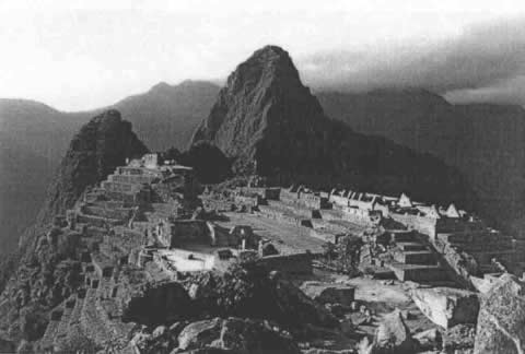
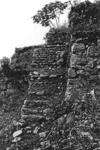
constructed drainage infrastructure at Machu Picchu, without which it would not have endured to the present
(Fig. 1). Machu Picchu served a permanent population of about 300 with a peak of 1,000 when the Inca emperor was in
residence. When Bingham stumbled upon the ruins of the beautiful Andean Inca community, it had endured nearly
intact for over four centuries without suffering from foundation failures or landslide damage (Bingham 1930) (Fig. 2). The potential ravages of time,
steep mountain slopes, and excessive rainfall were overcome by the exceptional ability of the Inca engineers to
construct good building foundations and install effective drainage systems. These two Inca achievements
delivered Machu Picchu to the 20th century scientists in a condition nearly as it had existed when it was
abandoned in the 16th century. It was occupied between 1450 and 1540 A.D., with some people remaining until
1572 A.D. (Rowe 1990). Machu Picchu, the royal estate of the Inca ruler Pachacuti (Rowe 1990), is
the most well known of all Inca archeological sites. While numerous visitors view the site in awe each year,
little was known about its paleohydrology or surface and subsurface drainage, or how the various infrastructure
components of this Andean community functioned. It was for this reason that the Peruvian government issued an
archeological permit to the writers in 1994 to carry out research on the agriculture, water supply, hydraulics,
and drainage of this ancient Andean community (Wright 1996); this paper deals
with its surface and subsurface drainage. When viewing the complex but orderly layout of the ruins, scientists and laymen alike express wonder and ask
questions about the drainage and potential irrigation of the numerous agricultural terraces. Because the annual
average precipitation likely was about 1,940 mm per year at the time of occupation, there was no need to irrigate
agricultural land at Machu Picchu, and field investigations by the writers indicated that no irrigation delivery
or distribution system existed [Wright et al. 1997(c)]. Fig. 3 presents the ice core data from the Quelccaya ice cap, representing long-term precipitation
patterns (Thompson et al. 1992; Thompson and Moseley-Thompson 1989). The Machu
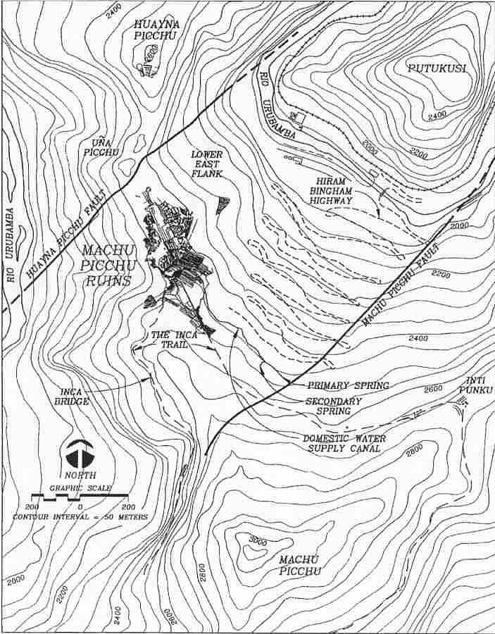
Picchu period is shown for comparison. SETTING AND GEOLOGYThe Inca royal estate of Machu Picchu is situated on a high mountain ridge between two prominent peaks
at an elevation of 2,438 m (Fig. 4). The ridge plunges precipitously
on both sides some 450 m to the Urubamba River. It would appear to be an unlikely location for ancient peoples
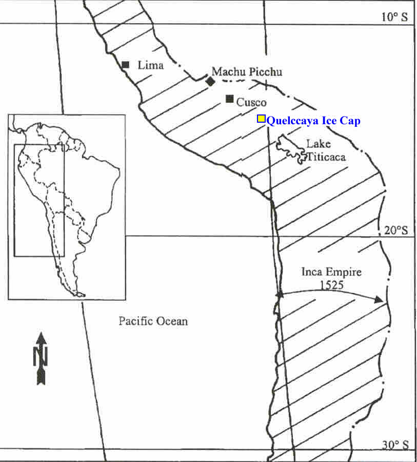
to have been able to construct a complex of beautiful buildings that would endure for so long a time. Machu Picchu is about 1,400 km south of the equator on the eastern slope of the Peruvian Andes
(Fig. 5). The site lies near the headwaters of the Amazon River, at long.
72o 32' W and lat. 13o9'S. Machu Picchu is laid out like a patchwork
quilt on a mountain ridge between two prominent mountain peaks-Machu Picchu and Huayna Picchu. The dramatic site
is a manifestation of tectonic forces and valley down, cutting by the Urubamba River, which meanders along three
sides of the ridgetop retreat. Further away, but visually dominating, is the ice-capped peak of Mount Veronica
to the east (5,850 m). This Inca site lies within the Cordillera Oriental (Eastern Cordillera) between the High Plateau and Subandine
zones of the Peruvian Andes (Marocco 1977) on a 40 km2 portion of
the complex Vilcabamba Batholith (Caillaux n.d.). This 250-million-year-old
intrusion is white to gray-colored granite, characterized by its abundance of quartz, feldspar, and mica
(predominantly biotite). This mineralogical composition made the granite of Machu Picchu a durable construction
material. Nonetheless, it was the inherent, rectangular joint pattern that the Inca workmen recognized and
masterfully used as building stones to construct Machu Picchu [Wright 1997(b)]. The most significant geologic characteristics of the Machu Picchu site are the numerous faults and abundant
rock fractures. Two principal faults are named for the two prominent local peaks: Huayna Picchu Fault and Machu
Picchu Fault, as shown in Fig. 4. These high-angle reverse faults formed a
wedge-shaped structural block relative to their namesakes. This block, or graben, is the structure on which
the ancient Inca people built their city. The Machu Picchu Fault influences the location at which the Machu
Picchu spring emerges. Increased permeability along upgradient portions of the fault system allows for
infiltration of precipitation and its emergence at the spring site, thus providing a perennial water source to
the Inca people [Wright 1997(b)]. The Machu Picchu fault system is also responsible for much of the topographic relief in the vicinity of
the mountain sanctuary. The orientation of the fault system can be identified by aligning the near-vertical
northwestern face of Machu Picchu with the linear reaches of the nearby Urubamba River along the southeastern
flank of Putucusi (Fig. 4). 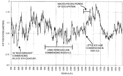
Figure 3. Long-Term 10-Year Running Average of Precipitation Based on
Quelccaya Ice Cap Cores by Byrd Polar Research Center at Ohio State University. Machu Picchu Primary
Occupation Period Is Shown from 1450 to 1540 AD.
 | Click on the image for a larger version. |
SOILS OF MACHU PICCHUThe characteristics of the soil in the agricultural terraces were determined from 16 of the writers' soil
samples tested by Dr. James Self of Colorado State University (CSU) Soil, Water, and Plant Testing Laboratory
in 1996 (Wright Water Engineers 1996). The writers had requested permission from Peruvian government representatives in February 1995 to take six
core samples from the terraces; however, the request was denied. Instead, the Instituto Nacional de Cultura
(INC) archaeologist, Snta. Elva Pino, commenced the formal excavations of six terrace sites and the collection
of over 100 soil samples from three strata at each test pit [Wright 1997(a)]. Soil samples were delivered to the writers by the INC Cusco director, along with a government resolution
authorizing their transfer to the United States. The CSU laboratory conducted a full array of agronomic tests
on the ancient soils. A summary of the results is presented in Table 1.
The soils were found to be deficient in numerous nutrient and macronutrient constituents, probably as a result
of four and a half centuries of in situ leaching and drainage of the substantial rainfall [Wright1997(a)]. The excavations and laboratory test results show that the topsoil was typically 0.5 m thick, and that even at
greater than 1 m deep, the subsoil of the deeper strata contained topsoil characteristics. Fortunately, the
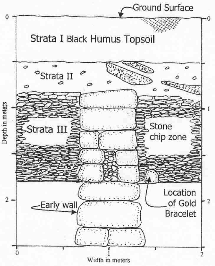
discovery of a gold bracelet in Test Pit No. 6 justified additional archaeological excavations by the INC
scientists during 1996. The subsequent and more extensive excavations have shown a deep subdrainage system,
representing the work of a well-organized and committed corporate agricultural society having knowledge of the
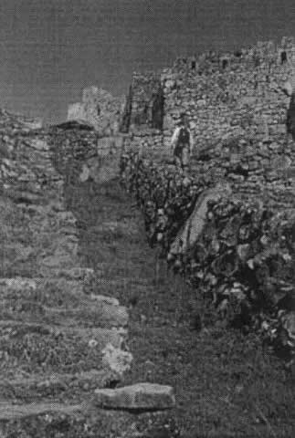
importance of good drainage of soil for sustained agricultural production and foundation stability ( Fig. 6). Fig. 7 shows the stability of the agricultural
terraces that supported the domestic water supply canal. The topsoil in the 4.9 hectares (ha) of the agricultural terraces was hand placed. The source of the soil,
whether from the Urubamba River floodplain far below Machu Picchu or from the slopes of nearby mountains,
could not be specifically identified from topsoil and sand particle characteristics and configurations. The Machu Picchu agricultural soils were determined to have good moisture-holding characteristics suitable
for sustaining crops in drier months, good agricultural soil texture, more than adequate soil horizon thickness,
and good drainage. The underlying subsurface drainage system was found to be excellent. 
Figure 4. Machu Picchu and Environs, Showing Two Main Geologic Faults
Associated with Machu Picchu, and Two Bordering Mountains of Huayna Picchu and Machu Picchu. Across
River Is Mountain of Putucusi.
| Click on the image for a larger version. |
CLIMATEMachu Picchu lies 13o south of the equator and has a dry winter season (May through August) and a
rainy summer season (October through March). The temperature of Machu Picchu is mild, and there is no frost
period. Seasonal temperature variations are considered modest. The precipitation and temperature characteristics
are summarized in Table 2. The ancient climate character was estimated using the published results of a 1,500-year ice core analysis
and correlating it with modern data collected at Machu Picchu. The ice core samples were from the Quelccaya
ice cap, located approximately 250 km southeast of Machu Picchu (Fig. 5).
These data reflect the general historic regional climate affecting ancient Machu Picchu and were used in
estimating the ancient climate. The detailed and extensive ice cap and glacier studies by the Byrd Polar Research
Center at Ohio State University were conducted by Thompson et al. (1985),
who recovered two cores from the glacier. One core represents the years 470 to 1984, and the other represents the
years 744 to 1984. These ice-coring data define wet and dry cycles extending from 470 to 1984 as shown in
Fig. 3 (Thompson et al. 1984). The long-
term (470 through 1984) average annual ice layer thickness for the two ice cores is about 1.4 m, estimated to
represent 1,990 mm of annual precipitation. 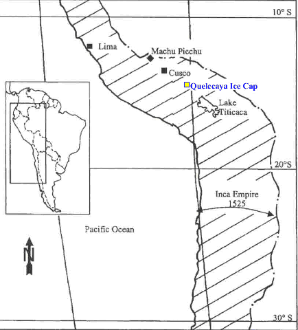
Figure 5. Map of Inca Empire at Time of Arrival of Conquistador
Pizarro in 1532. Machu Picchu Is Located 80 km Northwest of Inca Empire Capital of Cusco. Lima Is
Shown Only for Orientation.
| Click on the image for a larger version. |
For the modern period, available on-site climatological data from 1964 through 1977 were selected for analysis
of agricultural potential at Machu Picchu. The 1964 through 1977 ice cap record shows an average ice layer thickness
of 1.38 m, or about 99% of the long-term normal ice thickness ("Tropical" 1986).
For the 90-year period of primary occupation of Machu Picchu, the estimated decadal precipitation, as represented by
ice layer accumulations, is presented in Table 3, with the 1964 through 1977
period of ice accumulation shown at the bottom for comparison. The 1964 through 1977 precipitation, then, was similar
to that of the Machu Picchu period of occupation. The monthly precipitation recorded at Machu Picchu from May 1964
through December 1977 is presented in Table 4, based on data from SENAMMi
(Servicio Nacional de Meteorologia e Hidrologia), Cusco, Peru. It can be noted that the first 50 years of occupation at Machu Picchu were drier than the last 40 years. A marked
increase in ice layer thickness began in about 1500. This coincided with the well-documented Little Ice Age in the
northern hemisphere (Thompson et al. 1986). The precipitation for the 1450 through
1500 period, based on annual ice pack accumulation, was approximately 1,830 mm, or about 8% below the 470 to 1984
long-term average of 1,990 mm. The 1500 through 1540 period, on the other hand, was 5% wetter than the long-term
average with an equivalent annual precipitation of about 2,090 mm. As a result of the evaluation of the Quelccaya
ice cap data and the finding that the modern period precipitation was 99% of the long-term average and only 1% greater
than the 1450 to 1540 precipitation, the writers concluded that the modern period average annual precipitation data
were reasonably representative of the period-of-occupation average precipitation. The annual variations may have been
just as severe as those indicated by the modern data (Table 4). Table 1. Table 1. Topsoil Gradation in Strata I Machu Picchu Agricultural Terraces | Particle Size Gradiation |
|---|
| Particle Size | % Retained | Particle Size | % Retained | | <2 mm | 15 | 250 um | 14 | | 1 mm | 10 | 106 um | 15 | | 500 um | 16 | 53 um | 9 | | | | Constituent | % | Constituent | % | | Sand | 66 | Clay | 17 | | Silt | 17 | Texture | Sandy Loam |
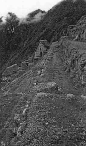
AGRICULTURAL TERRACESThe agricultural terraces of the Inca royal retreat of Machu Picchu complement the magnificent structures of
this mountaintop sanctuary, both physically and aesthetically. The terraces also provided protection from
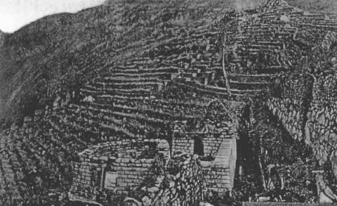
uncontrolled runoff and hillside erosion. The numerous ancient agricultural terraces, including those found on the lower flanks below Machu Picchu,
total 4.9 ha as determined by field and office studies by the writers. They are formed by stone retaining
walls, contain thick topsoil, and are well drained (Valencia and Gibaja 1992).
Deeper Strata II and III were more granular than the Strata I topsoil, which provided higher permeability to
enhance subsurface drainage. In deeper strata the Inca workmen provided excellent subsurface drainage with larger
stones and sometimes with stone chips from the stonecutting efforts. Field investigations were conducted to define the agricultural drainage, any potential irrigation water sources,
canals to conduct irrigation water to the agricultural sector, and any means to carry water to each of the many
terraces. The only outside water sources found at Machu Picchu were the domestic water supply springs on the north
face of Machu Picchu Mountain, the water of which was conveyed to the urban sector fountains via a small domestic
water supply canal (Fig. 7). The canal traverses the agricultural sector, but
there are no turnouts to the terraces. Field investigations were also made to determine whether or not drainage
water was reused for irrigation purposes. No evidence of reuse of drainage water for irrigation was found within
the Machu Picchu ruin. Neither was the discharge from the domestic water supply fountains reused for irrigation, but
merely discharged to the main drainageway. However, evidence was found that shows that agricultural drainage water,
along with basin subsurface runoff, was captured for several stone-formed fountains among the lower terraces downhill
from Machu Picchu [Wright et al. 1997(a)]. Evaluation of the estimated ancient rainfall showed that there was adequate water for crops without having to
resort to irrigation. This, along with the on-site studies, demonstrated that there was no irrigation at
Machu Picchu. 
Figure 6. Test Pit in Plaza Area Showing Soil Profile, Sand Lenses, Early Wall, Stone Chip Drainage
Zone, and Location of First and Only Gold found at Machu Picchu.
| Click on the image for a larger version. |
URBAN SECTORThe urban sector of Machu Picchu covers 8.5 ha and contains approximately 172 buildings, most of which were
covered with thatched roofs. These residential and temple areas of Machu Picchu were laced with granite stairways
and walkways, many of which also provided routes for drainage channels. Situated throughout the urban development
in the retaining walls and building walls are numerous surface drainage channels that, when coupled with the
drainage channels and subterranean chambers, define the drainage network. The density of buildings with impermeable
thatched roofs resulted in a generally high coefficient of runoff with a short time of concentration for the
rainfall-runoff relationships. Table 2. TABLE 2. Summary of Precipitation in Millimeters and Inches (1964–1977) | Precipitation (1) | Millimeters (2) | Inches (3) |
|---|
| Average annual | 1,960 | 77.2 | | Maximum annual | 2,400 | 94.4 | | Minimum annual | 1,490 | 58.6 | | Average May-August | 196 | 7.70 | | Average October-March | 1,472 | 58.1 |
Table 3. TABLE 3. Annual Precipitation at Machu Picchu during Occupation by Decade | Decade (1) | Precipitation (mm per year) |
|---|
| 1450–1459 | 1,770 | | 1460–1469 | 1,900 | | 1470–1479 | 1,830 | | 1480–1489 | 1,770 | | 1490–1499 | 1,860 | | 1500–1509 | 2,020 | | 1510–1519 | 2,150 | | 1520–1529 | 1,980 | | 1530–1539 | 2,220 | | Average | 1,940 | | 1967–1977 | 1,960 |
Table 4. Table 4. Monthly Precipitation at Machu Picchu in Millimeters. [Source: SENAMMi
(Servicio Nacional de Meteorologia e Hidrologia), Cusco, Peru]. | Month (1) | January (2) | February (3) | March (4) | April (5) | May (6) | June (7) | July (8) | August (9) | September (10) | October (11) | November (12) | December (13) | Annual (14) |
|---|
| Average | 285 | 321 | 304 | 183 | 49 | 33 | 47 | 66 | 102 | 153 | 171 | 241 | 1,955 | | Number of Years | 11 | 12 | 12 | 11 | 12 | 12 | 13 | 12 | 12 | 13 | 13 | 13 | --- | | Minimum | 231 | 227 | 148 | 58 | 0 | 2 | 15 | 27 | 24 | 58 | 79 | 142 | 1,489 | | Maximum | 381 | 449 | 339 | 311 | 124 | 111 | 132 | 126 | 191 | 293 | 313 | 303 | 2,398 |
DRAINAGEThe drainage at Machu Picchu and its special characteristics represent the secret of its longevity. This has long
been overlooked by archaeologists and scientists. Without good drainage and foundation construction, there would not be
much left of the royal estate of Emperor Pachacuti. The buildings would have crumbled and many of the agricultural
terraces would have collapsed due to the high rainfall, steep slopes, slideprone soils, and settlement. Surface and subsurface drainage at Machu Picchu was given high priority during its design and construction. For
instance,one can say that the miracle of Machu Picchu is not the beautiful buildings, which have been the subject of
past archeological studies, but the engineering features, which lie unseen underneath the ground, where some 60% of
the Inca construction effort centered. The drainage system at Machu Picchu has eight major components, summarized as follows: A centralized Main Drain serving to separate the Agricultural Sector from the Urban Sector
(Fig. 8). Agricultural terrace surface drainage with good longitudinal slopes to formal surface channels integrated
with access stairways or to the main open drain. Subsurface drainage of agricultural terraces at depth, typically consisting of ungraded rock chips and
stones overlaid with a layer of gravel and, above that, a layer of somewhat sandy material. Positive surface drainage of urban grassed or soil areas to drain the runoff from the many thatched roof
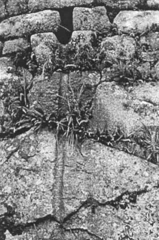
structures and plaza areas. In some places, thatched roof drip channels were cut into rocks (Fig. 9). Urban and agricultural drainage channels combined with stairways, walkways, or even temple interiors. Deep subsurface strata under plazas of rock chips and stones (Fig. 6)
to allow the plazas to receive and infiltrate runoff from tributary areas. A well-conceived and strategically placed urban area system of 129 drain outlets placed in the numerous stone
retaining and building walls (Fig. 10). Subterranean caves strategically used for drainage discharge, with relatively free subsurface flow via natural
underlying permeable deposits of granite rock falls.
ANNUAL WATER BUDGETAn annual water budget was used to estimate the amount of water yield, both surface and subsurface, using the
following parameters [Wright 1997(c)]. Annual average rainfall 1,940 mm Agricultural vegetation evapotranspiration 1,200 mm Composite unit urban area evaporation and evapotranspiration 600 mm
It was estimated that the agricultural terraces yielded 7,400 m3/ha/year. The urban area is estimated
to have yielded 13,400m3/ha/year. Based upon examination of the topography, lack of erosion, type of soils, likely vegetation cover, and subsurface
drainage potential, it is estimated that about 90% of the annual precipitation infiltrated and 10% resulted in surface
runoff. On the other hand, in the urban area, approximately 60% would be surface flow, with 40% infiltrated because of
the impermeability of the thatched roofs and compacted soils; however, much of the surface flow is later routed to the
plaza areas for infiltration and to caverns. The field survey of the Machu Picchu drainage system and the condition of the agricultural terraces and urban area
buildings and walls proves that the capacity and character of the subsurface drainage system was generally adequate
in terms of flow capacity and temporary detention storage to accept and transport the groundwater component of intense
storms to the hillside below. SURFACE RUNOFFThe ancient designers of Machu Picchu did not have the benefit of a written language, the wheel, or iron. The
building of a well-planned community with a substantial infrastructure in a remote mountainous environment
would be difficult even under modern conditions. Without the common "tools" of modern day life, it would seem
almost impossible. Nevertheless, using techniques developed by previous cultures, their own trial and error,
and techniques transferred from one generation to another by word of mouth, the Inca builders were able to
empirically size and design a surface drainage system that was remarkably effective ( Moseley 1992). One cannot speculate as to how the drainage system was conceived or how the empirical criteria were developed.
Undoubtedly, the long periods of building by pre-Inca Andean empires, such as the Wari and Tiwanaku, would have
given the Inca builders much opportunity to judge and copy what would work (Wright 1998). Drainage CriteriaBy studying the writers' map of Machu Picchu and analyzing urban drainage basins, and by computing the
capacity and documenting the spacing of the drainage outlets, rough empirical Inca drainage design criteria
were reconstructed. It was determined that a typical urban wall drainage outlet at Machu Picchu was based
upon criteria equivalent to those in Table 5. For agricultural drainage,
standards of design and construction were uniformly applied. Table 5. Table 5. Urban Surface Runoff Criteria for Wall Drainage Outlets | Primary (1) | Magnitude (2) |
|---|
| Tributary area per drainage outlet | 200m2 | | Drainage outlet size, typical | 10 by 13 cm | | Drainage outlet capacity, maximum | 650 L/min | | Design rainfall intensity | 200 mm/hour | | Rational formula runoff "C" | 0.8 | | Design flow per drainage outlet | 500 L/min | | Note: The writers do not assume that Inca had formalized criteria. Parameters shown represent approximate empirical equivalents. |
The surface drainage for the agricultural terraces is laid out with terrace slopes suitable for directing
any surface runoff lengthwise to the adjacent downslope drains. Inspection of the terraces by the writers and
examination of photographs taken in 1912 by Hiram Bingham indicate little erosional evidence of surface runoff,
even after four centuries of no maintenance and significant rainfall. The writers concluded that the surface
infiltration of rainfall to the subsoil drainage system was highly effective. The Test Pit 6 excavation in the
plaza west of the Temple of the Condor confirmed the adequacy of the subsurface system. The parallel surface
drainage system for the agricultural terraces, for the most part, provided redundancy and a drainage safety factor
for any high-intensity rainstorm events. Soil test results for the agricultural terraces demonstrated that the hand-placed topsoil was sandy loam
having an approximate infiltration rate of 10 cm/h and an available water holding capacity of about 0.14. The
underlying deep, loose stone drainage zone has a permeability of approximately 12 L per day per square
centimeter, with a storage coefficient estimated at 0.15. PLAZA SUBSURFACE DRAINAGEWhile the authors were denied permission by the INC to excavate or drill test holes into the agricultural
terraces and urban plazas, an INC archaeologist conducted excavations at six locations to provide soil samples
for laboratory testing by the writers. In Test Pit 6, which measured 2 by 2 m, three remarkable discoveries
were made: An ancient buried stone wall, which either represented an early (1450 A.D.) change in construction
plans or a temporary retaining wall for construction purposes (Fig.6). A subsurface layer of loose rock and stone chips at depth for underground drainage. The rock chips
found in the plaza represented a portion of the recycling of the thousands of cubic meters of waste chips
from the stonecutters. A gold bracelet that had been carefully placed at the foot of the buried stone wall between two
guard rocks, perhaps as an offering to Pachamama (Earth Mother).
The subsurface chipped rock stratum was about 1 m thick with an estimated coefficient of permeability
of about 160 m/day and detention capacity of about 150 L/m3. As a result, the deep percolation
from a major rainfall event could be temporarily stored in the subsurface chipped rock stratum and slowly
released to the downstream subsurface discharge point at a modest rate without causing a high groundwater
table, which otherwise would have led to instability of the plaza and its soils. The plaza areas were also used to receive and dispose of storm drainage from adjacent urbanized tributary
basins via infiltration and subsurface runoff. Again, as a safety factor, the Inca engineers also constructed
surface drainage facilities for the plaza area. 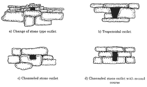
Figure 11. Typical Surface Drain Outlets in Building Walls at Machu Picchu.
| Click on the image for a larger version. |
SPECIAL DRAINAGE FACILITIESThe descriptions of the general drainage features and criteria for Machu Picchu provide evidence to
support Hiram Bingham's estimate of Inca engineering capabilities. However, the investigation of specific
drainage features demonstrates the special care taken by the ancient designers on a site-specific basis.
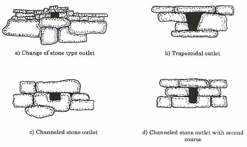
Fig. 11 illustrates details of Inca stone wall drainage outlets at Machu
Picchu. Specific facilities are described below. Emperor's ResidenceMuch like the entrance to a department store in a shopping center, where surface drainage is a necessity,
the entrance to the emperor's residence in Machu Picchu was well drained. A small channel was constructed
from west to east at the single entrance to the royal residence. The channel then passes through a retaining
wall via a drainage outlet, where the water would drop about 0.7 m to another west east flowing channel with
a 2% grade. Five meters downstream, a drainage outlet and channel from the emperor's bath area joined this
channel. The channel then penetrated another exterior wall and continued to another drainage outlet, which
discharged to a channel along a main pathway. The emperor's entrance drainage system, because of its fine construction and stonework, was long thought to
be an additional fountain somehow supplied with an underground conduit from Fountain 1. The special surface
drainage at this location provides a good example of the care taken to ensure that stormwater would be properly
conducted to a suitable discharge point. Sacred RockThe Sacred Rock is flanked by two three-sided and thatched roofed buildings called wayronas. Here, rainfall
off the thatched roofs drops onto the small plaza between the wayronas, where peripheral surface drains carry
the stormwater west to a low retaining wall containing three wall drainage outlets. These discharge to the large
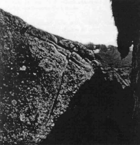
plaza area separating the East and West Urban Sectors, thus avoiding ponding of surface water. Behind the southern wayrona, a large rock has a drip and drainage channel carved into it (Fig. 9). Water from the roof would drip onto the rock and be carried away from the wayrona's
foundation. The location of the drip channel indicates that the Inca thatched roof was much thicker than the
reconstructed thatched roof. Agricultural Terrace Horizontal DrainDuring the period of occupation and while under construction, the Inca builders experienced ground slippage
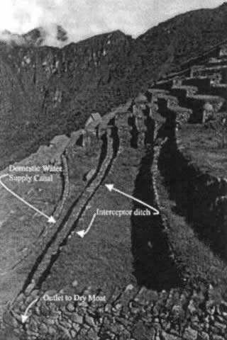
in the agricultural terrace area adjacent to the Main Drain (Dry Moat).The slide was satisfactorily stabilized,
but not before the Inca workmen had taken effective steps to control surface water runoff. A large cross-section interceptor surface drain was constructed from south to north at the base of a long
slope and immediately above the domestic water supply canal (Fig. 12).
The steep sloping interceptor drain, about 42 m long, terminated at the Main Drain after passing through the
south wall of the Main Drain. Much of the uphill slope of this formerly unstable area is void of agricultural
terraces, indicating that the builders of Machu Picchu decided not to construct agriculture terraces in the area. Field evidence consisting of an adjacent granite stairway free of damage but with post-construction terrace
wall deflections, shows that the slide occurred during the period of construction and that the slope had been
satisfactorily stabilized prior to the Inca abandonment of Machu Picchu. EXPLORATIONDuring 1996 1997, the paleohydrological team explored the lower east flank of Machu Picchu for additional
hydraulic works because, following a 1969 forest fire, Valencia Zegarra
(1998) had noted five groups of terraces and several fountains there. Five ancient fountains were found in the
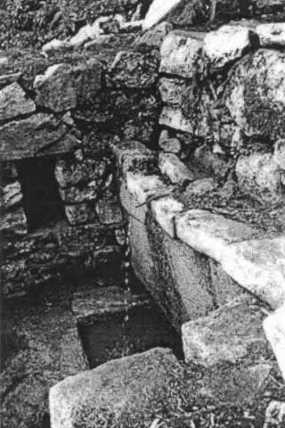
rainforest along with the terraces (Wright 2000). A September 1998 excavation permit from the government allowed excavation of the fountains, two of which were
ceremonial fountains that were put into operation again after being buried for over four centuries
(Fig. 13). The 1998 field exploration resulted in more than the excavation of the fountains: a previously unknown Inca
trail was discovered. The trail is typically 2 m wide, with many excellent granite staircases ranging up to 3 m
wide (Fig. 14). The Inca trail route was followed through the thick
rainforest all -the way down to the Urubamba River, where the ancient low water crossing was found. The trail is
judged by the writers as being the primary trail from Machu Picchu to the easterly Vilcabamba region. The trail infrastructures included formalized drainage works ranging from subsurface channels to surface drains
and well-constructed terraces to control surface runoff and provide slope stability. The trail and terraces were
found to be in excellent condition, free of landslides and erosion. Damage to two of the fountains had occurred as
a result of rockfalls from above. SUMMARY OF FINDINGSThe Inca drainage planning at the royal estate of Machu Picchu was well conceived and constructed. The surface and
subsurface drainage works were built to manage the nearly 2,000 mm of average rainfall per year and to protect the
magnificent royal estate from damage due to potential landslides, settlement, and erosion. Hiram Bingham was correct
in 1913 when he reported to the world that the ``Inca were good engineers" ( Bingham 1913). The agricultural terraces required no irrigation; they were well drained and also provided an important
visual amenity to the community. When Bingham photographed the terrace in 1912, he recorded that, despite being
"lost" for centuries, the stone terrace walls were still in nearly perfect condition. The climate during the Inca primary period of occupation, 1450 to 1540, was similar to the modern climate.
It has been demonstrated that the site was not abandoned due to a domestic water shortage. The drainage scheme of Machu Picchu is based on orderly and well-planned surface and subsurface drainage.
An empirical system of sizing and location of drainage outlets worked well for the Inca builders. The system
was likely based on trial and error methods of the Inca and centuries of experience of preceding Andean empires. The remarkable subsurface drainage works found under the plaza provided a stormwater infiltration and
disposal area. The thick layer of rocks and waste stone chips provided adequate permeability for flow, as
well as a subsurface storage reservoir to avoid a high water table condition during high-intensity rainstorms. The Inca ingenuity for constructing effective drainage works is exemplified by the Royal Residence, Sacred
Rock, and agricultural terrace area. The Inca builders constructed Machu Picchu to last for an eternity, and
in doing so, they built good drainage facilities and foundations that would withstand the elements. APPENDIX. REFERENCESBingham, H. (1913). "In the Wonderland of Peru." Nat. Geographic Mag., April 23, 387 573. Bingham, H. (1930). Machu Picchu: A citadel of the Incas. Yale University Press, New Haven, Conn. Caillaux, V. C. (n.d.) La geologia en la conservacion del santuario historico de Machu Picchu. Marocco, R. (1977). "Geologie des Andes Peruviennes: Un segment W.E. de la chaine des Andes Peruviennes; la
deflexion D'Abancy-Etude geologique de la Cordillere Orientale et des hauts plateaux entre Cusco et San Miguel,"
PhD thesis, Academie de Montpellier, Universite des Sciences et Techniques de Languedoc, Montpellier, France. Moseley, M. E. (1992). The Incas and their ancestors: The archaeology of Peru . Thames and Hudson, London. Rowe, J. H. (1990). "Machu Picchu a la luz de documentos de siglo XVI." Historica, 14(1), 139 154. Thompson, L. G., and Moseley-Thompson, E. (1989). "One-half millennia of tropical climate variability as
recorded in the stratigraphy of the Quelccaya ice cap, Peru." Geophysical Monograph, American
Geophysical Union, 55. Thompson, L. G., Moseley-Thompson, E., Bolzan, J. F., and Koci, B. R. (1985). "A 1500-year record of
tropical precipitation in ice cores from the Quelccaya ice cap, Peru." Science, 229, 229(4717), 971 973. Thompson, L. G., Moseley-Thompson, E., Dansgaard, W., and Grootes, P. M. (1986). "The Little Ice Age as
recorded in the stratigraphy of the tropical Quelccaya ice cap." Science , 234(4774), 361 364. Thompson, L. G., Moseley-Thompson, E., and Morales, Arnao B. (1984). "El oscillation events recorded in
the stratigraphy of the Nino-southern tropical Quelccaya ice cap, Peru." Science, 226, 226(4670), 50 52. Thompson, L. G., Moseley-Thompson, E., and Thompson, P. A. (1992). "Reconstructing interannual climate
variability from tropical and subtropical ice-core records." El Nino historical paleoclimatic aspects of
the southern oscillation , Diaz, H. F., and Markgraf, V., eds., Cambridge University Press, Cambridge, U.K. Tropical ice core paleoclimatic records: Quelccaya Ice Cap, Peru, AD 470 to 1984 . (1986). Nat.
Geographic Data Ctr., Nat. Oceanic and Atmospheric Admin., Byrd Polar Res. Ctr., Ohio State University,
Columbus, Ohio, distributed by NGDC, Boulder, Colo. Valencia Zegarra, A. (1998). "Excavaciones en las fuentes del flanco oriental de Machu Picchu." Rep.
to Instituto Nacional de Cultura, Universidad Nacional de San Antonio Abad del Cusco, Cusco, Peru. Valencia Zegarra, A., and Gibaja Oviedo, A. (1992). Machu Picchu: La investigacion y conservacion
del monumentos arqueolo ´gico despues de Hiram Bingham. Municipalidad del Qosqo, Peru, Cusco. Wright, K. R. (1996). "The unseen Machu Picchu: A study by modern engineers." South Am. Explorer,
46, Winter, 4 16. Wright, K. R. (1998). "The lessons of history, El and the fall of Nino empires." South Am. Explorer,
53. Wright, K. R. (2000). "Inca trail discovery at Machu Picchu." South Am. Explorer, in press. Wright, K. R., Kelly, J. M., and Valencia Zegarra, A. (1997a). "Machu Picchu: Ancient hydraulic engineering."
J. Hydr. Engrg., ASCE, 123(10), 838 843. Wright, K. R., Witt, G. D., and Valencia Zegarra, A. (1997b). "Hydrogeology and paleohydrology of ancient
Machu Picchu." Ground Water, 35(4), 660 666. Wright, K. R., Wright, R. M., Jensen, M. E., and Valencia Zegarra, A.(1997c). "Machu Picchu ancient
agricultural potential." Appl. Engrg.in Agr., 13(1), 39 47. Wright Water Engineers, Inc. (1996). Letter report to the Instituto Nacional de Cultura Departmental Cusco
reporting findings of the soil sample testing at Colorado State University. (Results may be obtained directly
from CSU. Dr. James Self, Colorado State University, Soil, Water and Plant Testing Laboratory, Room A319,
Natural and Environmental Science Building, Fort Collins, CO 80523 1120.) FOOTNOTESPres., Wright Water Engineers, Inc., 2490 W. 26th Ave., Suite 100A, Denver, CO 80211; Dir.,
Machu Picchu Paleohydrological Survey. Registered Archaeologist, Peru; Prof., Dept. of Anthropology and Archaeology, Universidad
Nacional de San Antonio Abad del Cusco, Cusco, Peru. Sr. Consultant, Wright Water Engineers, Inc., 2490 W. 26th Ave., Suite 100A, Denver, CO.
Note. Discussion open until May 1, 2000. To extend the closing dateone month, a written request must be
filed with the ASCE Manager of Journals. The manuscript for this paper was submitted for review and possible
publication on December 10, 1998. This paper is part of the Journal of Irrigation and Drainage
Engineering, Vol. 125, No. 6, November/December, 1999. ASCE, ISSN 0733-9437/99/0006-0360-0369/$8.00
$.50 per page. Paper No. 19153. |
|
|