 | Click Here for a PDF (printer friendly) version |
With bright eyes, Ruth Wright recalls her second visit to Machu Picchu. She had traveled there with her husband, Kenneth R. Wright [president of Wright Water Engineers of Denver, CO], to search for the spring that supplied water to the Inca people who lived there some 450 years ago. A local Quechua Indian led them through the dense forest to the spot where the water emerged from the ground. The Wrights knew they had found what they were looking for when the man showed them a carved stone foundation, tapping it with the handle of his machete. "Inca," he told them. "Inca."
The city of Machu Picchu, once the royal estate of a powerful Inca emperor, lay hidden in the mountains of Peru until 1911, when Hiram Bingham, a professor of history at Yale, discovered its ruins. Since then, it has become perhaps the most important archeological site in the Americas. Most people know Machu Picchu not for its history, but for its breathtaking beauty (see Photograph 1). For years, few even with the scientific community recognized that it also represents a remarkable achievement of civil engineering.
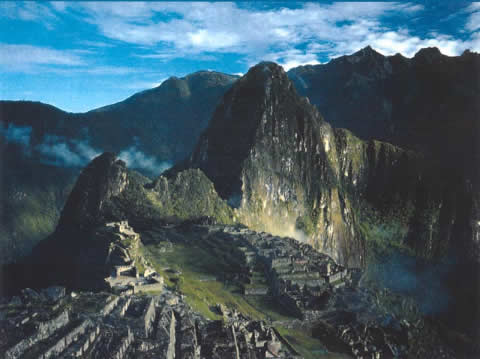
Photograph 1. Machu Picchu's unique geography presented Inca engineers with a number of challenges
In 1450 the Inca came to [Machu Picchu]–2,440 m. high mountain ridge in the Andes–with one goal in mind: to build an estate for their emperor, Pachacuti. "They had a perfect site," notes Wright, but its suitability would been apparent only to a trained engineer. The slopes were steep; how would buildings be prevented from sliding downhill in a heavy rain? How would drinking water be made accessible?
Water Supply
Wright's research revealed that the Inca must have planned the city carefully before building it. First, the Inca engineers had to determine the exact location of the spring and whether it would meet the needs of the anticipated population. The Wright team found that the spring, on the steep mountain slope to the north of Machu Picchu, is fed by a 16.3 ha tributary basin. After conducting an inflow-outflow evaluation, the team also concluded that the spring draws on drainage from a much larger hydro-geographic catchment basin.
The Inca enhanced the yield of the spring by building a spring collection system set into the hillside. The system consists of a stone wall about 14.6 m long and up to 1.4 m high. Water from the spring seeps through the wall into a rectangular stone trench about 0.8 m wide. Water from a secondary spring enters the canal about 80 m west of the primary spring. The Inca also built a 1.5 to 2 m wide terrace to allow easy access for operating and maintaining the spring works. The condition of the spring works surprised Wright. "The spring works was still intact and still working," he says. "It was still yielding a water supply after all these centuries of abandonment."
Before the city could be built, however, the Inca engineers had to plan how to convey the water from the spring–at an elevation of 2,458 m–to the proposed site on the ridge below. They decided to build a canal 749 m long with a slope of about 3 percent. With the city walls, the water would be made accessible through a series of 16 fountains, the first of which would be reserved for the emperor. Thus the canal design, says Wright, determined the location of the emperor's residence and the layout of the entire city of Machu Picchu.
The Inca built the water supply canal on a relatively steady grade, depending on gravity flow to carry the water from the spring to the city center. They used cut stones to construct a channel that typically ranged from 10 to 16 cm deep and 10 to 12 cm wide at the bottom. Wright's team concluded that the nominal design capacity of the channel was about 300 L/min, or more than twice the typical 25 to 150 L/min yield of the primary spring (see Photograph 2).
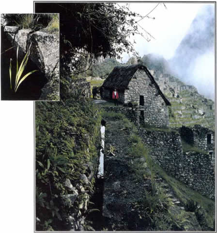
Photograph 2. The Inca supply canal flowed gently into Machu Picchu at an engineered grade on a carefully built terraced right-of-way.
The canal descends the mountain slope, enters the city walls, passes through the agricultural sector, then crosses the inner wall into the urban sector, where it feeds a series of 16 fountains known as the stairway of fountains. The fountains are publicly accessible and partially enclosed by walls that are typically about 1.2 m high, except for the lowest fountain, which is a private fountain for the Temple of the Condor and has higher walls. At the head of each fountain, a cut stone conduit carries the water to a rectangular spout, which is shaped to create a jet of water suitable for filling aryballo–a typical Inca clay water jug. The water collects in a stone basin in the floor of the fountain, then enters a circular drain that delivers it to the approach channel for the next fountain.
Wright and his team studied the fountains in detail, conducting hydraulic flow tests and measuring the channels and outlets (see Photograph 3). They concluded that the Inca designed the fountains to operate optimally with a flow of about 25 L/min, but the fountains would operate with flows as low as 10 L/min and could handle a maximum flow of 100 L/min. The team found water control points at two places along the canal where excess water would have spilled onto the agricultural terraces or into Machu Picchu's main drain before reaching the fountains.
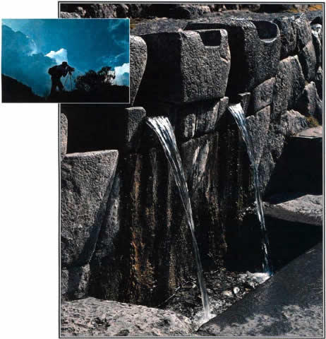
Photograph 3. The water supply canal ends in a series of 16 semiprivate fountains.
Wright's study of Machu Picchu's hydrology and hydraulic engineering led him to conclude that the Inca understood the importance of pure drinking water. The surface drainage system generally directed agricultural and urban storm water runoff away from the water supply canal. Wright also notes that the Inca apparently did not use the fountains for bathing. The emperor, for example, had a bathing room with a separate drain, so that bathing water did not reenter the water supply.
In 1998 Wright's team discovered another, previously unknown series of fountains on the eastern side of the ridge, downhill from Machu Picchu. These fountains received their water not from the canal but from intercepted groundwater drainage. While elaborate spring works were not necessary here, Wright says, the Inca would have had to identify the dry-weather groundwater flow locations to concentrate the flow for use in the fountains. Adjacent to some of the fountains, an important trail, which Wright's team also discovered, connected Machu Picchu to the Urubamba River in the valley below. After clearing away the dense forest undergrowth, the team restored the water flow to this second series of fountains for probably the first time in 450 years.
How successful were the Inca in planning their water supply? Observers have advanced several theories to explain why the Inca abandoned Machu Picchu; some suggest that a water shortage forced the Inca to leave. Wright says his research puts that theory to rest.
A hydrological analysis showed that the yield of the primary spring was related to rainfall. determine rainfall levels during the time the Inca occupied Machu Picchu–from 1450 to about 1540–Wright analyzed ice core data from a glacier that lies 250 km to the southeast. The analysis suggested that Machu Picchu received nearly 2,000 mm of rainfall annually and that in the final decade of occupancy rainfall actually increased.
Wright determined that a flow of 10 L/min to the fountains during the dry months would have been enough to meet the needs of the population–estimated to have varied from 300 to 1,000 when the emperor was in residence. In the winter of a dry year, Wright says, the Inca may have experienced a temporary water shortage. But his discovery of the trail leading down to the Urubamba River seemed to confirm that the Inca would have used the river as a secondary water source water source. Therefore, Wright concluded, a water shortage does not explain the abandonment of Machu Picchu.
Drainage
At Machu Picchu, drainage is a serious problem. The site rests on top of a ridge with a roughly 50 percent slope. The site rested on top of a ridge with a roughly 50 percent slope and received almost 2,000 mm of rainfall. For their city to endure, the Inca had to find a way to keep it from sliding down the mountain.
Perhaps the most visually striking features of the drainage system are the agricultural terraces. Machu Picchu includes 4.9 ha of agricultural terraces, which are held in place by stone retaining walls. In addition to maximizing the land available for farming, the terraces also protected the agricultural sector from erosion. Wright conducted soil analyses that showed that the Inca constructed the terraces with subsurface drainage in mind. They layered each terrace for efficient drainage, with a layer of stones at the bottom, followed by gravel, sandy material, and topsoil.
The terrace structures also promote good surface drainage, Wright found. The slope of terraces generally directs water toward a system of drainage channels that are integrated with stairways and other structures. These channels direct the drainage water to a large, east-west main drain that runs through the center of Machu Picchu, separating the agricultural and urban sectors. Gravity flow carries runoff into the main drain in both sectors, taking it safely away from the city.
In one instance, the Inca apparently experienced a landslide while a part of the terrace area was under construction. Wright notes that in this area, close to the main drain, the terraces are offset by 1 to 2 m. Wright speculates that after the landslide, the Inca stabilized the terraces and continued to build the walls but did not attempt to correct the offset. The Inca engineers realized, however, the importance of controlling surface runoff in this area. Just uphill from the place where the water supply canal crosses the terraces, they built a north-south interceptor drain. This 42 m long channel carries runoff from the land above into the main rain.
In the urban sector, the Inca took equal care to address drainage. Wright's excavations found that the Inca constructed their plazas in the same way as their terraces, with a deep subsurface layer of rock chips. The plazas received runoff from other areas of Machu Picchu, and the subsurface layer of rocks helped the water to penetrate the ground quickly.
To understand the problem of urban surface drainage at Machu Picchu, it is important to remember that the city appeared much different in the 15th century than it does today. The buildings in the urban sector would have been covered with thick thatched roofs, Wright estimated that about 60 percent of the water yield from the urban area would have occurred as surface flow.
To deal with the runoff problem, the Inca incorporated about 130 drainage holes into the walls and other structures at Machu Picchu. They also integrated numerous drainage channels into stairways, walkways, and building interiors to carry runoff to the main drain. One especially carefully constructed channel drains water away from the entrance to the emperor's residence. To direct water away from building foundations, the Inca carved channels that would collect the water that dripped from the roofs.
Based on their measurements of the urban drainage outlets, Wright's team calculated rough Inca drainage criteria. They determined that the Inca placed one outlet for a tributary area of about 200 m2, and the design flow per outlet was about 500 L/min. The typical outlet size was 10 by 13 cm. The Inca departed from this scheme, however, when other means were available to remove runoff. As the Temple of the Condor, for instance, they built only one drainage outlet for an area of 0.045 ha, apparently because they understood that a system of subterranean caves beneath the temple was sufficient to handle the runoff.
Machu Picchu's well-designed drainage infrastructure is one of its most remarkable secrets. It is also one of the keys to its longevity, says Wright: "They built for permanency. They didn't go halfway." Perhaps the greatest testimony to their success is that the city still exists in such good condition.
Agriculture
[Wright has also answered two questions] that have often been asked of Machu Picchu: Were the crops irrigated or was rainfall sufficient to support the agriculture? Did the terraces produce enough food for the population?
Wright's analysis of the annual rainfall and crop requirements determined that the rainfall was sufficient to supply the crops. This finding corroborated his study of the water supply and drainage infrastructure, which showed no evidence that the Inca irrigated their crops. The water supply canal crosses the agricultural sector but includes no turnouts to irrigate the terraces. In addition, Wright found no evidence that surface runoff was used for irrigation; it was simply directed into the drainage system.
The study did show, however, that the crops grown on the agricultural terraces–probably mostly corn and potatoes–would not have been enough to feed the resident population. Therefore, he concluded, the Inca must have imported food to Machu Picchu.
For More Information
[During the years] he has been working in Peru, Wright has collaborated closely with Alfredo Valencarchaeologistra, a Peruvian archeologist who has studied Machu Picchu for much of his professional life. They work well together, says Valencia Zegarra, who speaks highly of Wright's contribution.
Wright frequently expresses his appreciation for Valencia Zegarra's work, crediting him with providing the much-needed cultural and historical context. "We are able to speak with certainty about these things because of him," he says. The two recently collaborated on a book, Machu Picchu: A Civil Engineering Marvel, that summarizes their research. ASCE Press(www.pubs.asce.org) published the book in October 2000. The list price is $49.