Battening-Down Hatch
| |
Let fate do her worst; there are moments of joy,
Bright dreams of the past which she cannot destroy
That come in the night time of sorrow and care,
And bring back the features that joy used to wear.
| | | --Moore | |
from "A Souvenier of Your Teacher"
James B. Burrow
Hatchtown School
1897- 1898
Introducing HatchEffel Burrow Riggs has lived most of her 91 active years in Hatch, Utah, which has a
population in 1985 of 121 people. Visiting her in June, I heard Effel repeat for me the most
popularly accepted reason why Hatch has remained village-sized. "Some people here say we only
have two seasons: nine months of winter and three months of darn cold weather." Coming from the south or southwest, one finds that Hatch is just across the ridge from Long
Valley, at the very head of the Sevier River. West of Hatch is the Markagunt plateau (10,567
feet above sea level at the Cedar Breaks); on the east is the Paunsagunt plateau (9,630 feet at
Black Butte). The Markagunt is the closer and the higher, and it provides much of the water at
its greatest source for every community downstream from Hatch. The Paunsagunt Plateau is
farther and drier. The benches leading up to it are less steep until one approaches the
7,400-foot contour, where, several miles from Hatch, the topography leaps up suddenly about
2,000 feet per linear mile. It is on the Paunsagunt where the geological phenomena are found
that make Bryce Canyon National Park. Hatch is geographically located in the Sevier Valley, but it is close enough to Long Valley
(in which are found the headwaters of the East Fork of the virgin River) physically and
historically that the geographic divide seems almost unimportant. The Long Valley Junction to
Dixie (Southwestern Utah) lies in Kane County, just over the divide. Hatch is politically
divided from both Kane and washington Counties, and the Sevier River flows northwards, but
history binds Hatch to Long Valley, the Virgin River, and the old Santa Clara missions. As of this date, the Sevier River at Hatch flows by almost unnoticed, except by members of
the Hatch Irrigation Company. In all seasons of the year, but in larger volume in March, April,
and May, water runs out of Castle, Asay, and Mammoth Creeks to create the main fork of the
Sevier, flowing north towards Panguitch and Kingston, where, with waters out of Otter Creek and
the East Fork it helps fill Piute Reservoir. Meltiar HatchMeltiar (pronounced mel'-tire) Hatch had things going his way at Santa Clara by 1863. Things
were roughly-hewn, but they were moving. He had been married to Permelia Snyder for 17 years
and to Mary Ann Ellis for 7, and he was thus responsible for two households. He had cattle,
sheep, oxen and a number of horses. Very likely he also owned some barnyard and household
animals. He was 38 years old, born in upstate New York, but he had been in Utah Territory since
1847, having arrived at the mouth of Emigration Canyon on July 24th. He took to the "Wide West"
as though he had been born and raised in it and didn't know of anything different. In their hot,
sunny little desert worlds, he and his two wives would eventually account for 19 children. By
1863, a couple of Permelia's boys were old enough to help with the animals on the ranch.
Meltiar had no papers to prove his proprietorship on homesteads any where he had settled, but,
as long as Brother Brigham allowed him so to remain anywhere, he held to his squatter's rights
everywhere he went with his labor and that of his wives and their oldest children. One may
safely presume he had firearms to help hold on to things also, but with his Mormon neighbors
they were not necessary. At Santa Clara he and Permelia and Mary Ann had worked out a routine that made it possible
to take cattle up into Mountain Meadow and leave them there to rustle for themselves all summer.
This took a little buckarooing, keeping track of them and their calves and protecting them from
Indian raids. It is easy to imagine what Permelia and Mary Ann did with their lives. There is no public
record of their innermost thoughts about polygamy as an institution, but a picture taken of
them many years later shows them (long after the Edmunds Act of 1880 had separated Mary Ann
from Meltiar) arm-in-arm with each other and with Meltiar's sister Rhoana. They didn't have
much time to philosophize about it, because what made their lives meaningful, and romance a
little evasive, was the obvious daily concentration on survival. In order to survive, each wife
tended her own children (and the other's too, when illness afflicted the one or the other of
them), and they had help from all of their children as early as possible to chop the wood, haul
the water, wash the wool, spin it, color it, and weave it. They made clothes, gloves, and hats
for the two families, cooked the meals, took care of the sick and the injured, consoled the
angry and frustrated, and rocked the babies. If that could be done within 15 to 20 hours, they
had all the rest of their time to themselves. They got along. Everything was cozy, and everybody was snug in the two family rugs, along,
no doubt, with desert bugs. At least, nobody worried about who he and she was or about their
roots. Meltiar had settled some land in 1862 about three miles up the Santa Clara River on which he
had constructed a sturdy one-room house under a cool willow. One room was a standard amount for
houses of most families in Utah in those days, especially at the beginning; one room and a loft;
in some cases, no loft. Since Permelia was the first and older wife, she had the most and the
oldest children, and one may infer from this that the house was hers, leaving Mary Ann to live
in a wagonbox under canvas, until Meltiar could get around to building one for her. Weltha Maria, Permelia's oldest girl, was about seven years old then, and in 1925 she told
some people, comfortably inhabiting the 2Oth century, about that one-room cabin and the willow
tree. "We thought we were well-off," she told them, somewhat surprised that anybody should ever
think differently. "None had better." To be content, one hears, is a masterpiece. So much for contentment. It is not an American characteristic. One room for the family
doesn't leave much privacy. It doesn't leave much room for delusions either. Weltha Maria and
all of her brothers and sisters, half and full, suffered no illusions about entitlements.
Everything then was God-ordained and God-directed, but you did the work. It never occurred to
God as it has to man's legislatures, to put a label on "life," warning people that it was
dangerous to their health, making people born into it that sooner or later it would kill them.
How soon or how late was mostly patented somewhere else, but, on having life one is suddenly
responsible for doing something with it, healthy or sick, wealthy or impoverished. In the Bible,
God doesn't call it a piece of cake. Weltha Maria started her pioneering at birth in Session's Settlement (Bountiful) in 1855.
She was still in swaddling clothes when her mother and father packed her and her older brothers
out to Carson Valley (still in Utah Territory in those days) with John Reese's company, to
found Mormon Station (now Genoa, Nevada). This was Meltiar's first "call" into the wilderness.
After that, they spent a winter in Lehi, Meltiar having received another "call." They
lived for a while in "Snyderville," which was near "Parley's Park." It was about then that
Meltiar, acting on a suggestion by President Brigham Young, took Mary Ann Ellis to wife, and
Weltha Maria, the daughter of Permelia, grew up with that fact. When Meltiar received his "call" to go to southern Utah it was almost 1862, and it was a
likely place to set roots with a couple of growing families. But just as they got that one-room
cabin raised under the willow, just as Meltiar's cattle and sheep were fattening in Mountain
Meadow, and just as Permelia and Mary Ann were finding a few places to put things (and maybe
just as Mary Ann was beginning to dream carefully about a one-room house of her own), Brother
Brigham "called" again. In 1864, he "called" loudly enough across the 300-miles-and-more between
Salt Lake City and the Santa Clara mission to indicate that the "western valleys" needed some
Mormon settlement. For Meltiar and a few others he meant Eagle Valley, about 90 miles west of
Cedar City, even west of the sparse Escalante Desert. Brother Brigham had his reasons, and they
were related to some interterritorial politics he had wind of. It is not known how much
knowledge of that politics he passed along to his people in the farflung missions in the
south. Meltiar must have looked like a cattleman to Brother Brigham, for those open ranges in the
western valleys were rich in virgin bunchgrass amidst nutritious sagebrush. This was big-ranch
country, with some bottomlands for wild hay and some grain. Meltiar took everything in stride,
good or bad, whether he understood about the politics or not. If he had any significant
feelings about being planted and uprooted several times in just a few years, he judiciously
mumbled them to himself. Above all, Meltiar was a man who knew himself and was inwardly at
peace. It had never been his understanding that being a member of "the only true Church of God
on earth" was supposed to be the easiest thing in the world. Because they accepted the principle of the authority of the priesthood, whatever Meltiar
thought was automatically conveyed to Permelia, Mary Ann, and the children. You can hardly call
it an "option," when there is only one choice, and theirs was to "disroot" and find Eagle
valley, there to "re-root," and that was in 1864. "It was in the springtime of the year," Weltha Maria Hatch Lynn told folks in 1925. She
omitted details of the desert journey, but in the springtime the desert flaunts life, and there
were flowers to glory in, and the summer was not yet lying in deep heat over the Escalante
Desert. They departed from southern Utah, from "Dixie," by way of the Santa Clara river and
Mountain Meadow, and with sheep and cattle to herd, and with at least two wagons and yokes of
oxen to "gee-haw," or whatever it was they said to oxen to make them pull a little harder, it
had to be a slow journey across those 125 mile-or-less miles to Eagle Valley. There, said
Weltha Maria, "Father took the boxes from the wagons and set them on the ground and built
willow shades over them for us to live in while he brought logs from (nearby) mountains to
build a house." No longer in the Virgin River basin, no longer in Dixie, here they were deep
into the Great Basin, from which no river runs out to the sea. With others, they eventually
founded their community of Panaca. With all of that they were as comfortable as any Piute family. They had willow wickiups
covering their wagonbeds, just like the wealthiest Piutes, and what more could anyone ask in a
new land where from any desert waterhole you had to travel a whole day or more to get to timber?
The promise of a house here was no less than a promise at Santa Clara, and looking about them
at the waving grass and brush and at the wide valleys between mountains, all open and honest
and tough under the bluest of skies, they must have felt they had a chance of becoming part of
that land as stock ranchers. The future was always tomorrow, just a step ahead, never more than
one more grope. One hundred years later it does seem that "freedom" to them was something more
than the absence of physical chains; it was largely a matter of exercising a thing they felt
called "hope," the third corner of that Christian triangle that includes "faith" and "charity,"
even though some wise man once called hope "that thing with feathers." Anyway, they were in Eagle Valley for about eight years, and by then Eagle Valley felt so
much like home that maybe they forgot Dixie. More children were born to both families, and
those children only knew Dixie from hearsay anyway. Meltiar became a bishop, and his posterity
increased here, but his posterity did not end here. More of it was just around the corner. Weltha Maria had turned 15 painlessly, but she still had little time for much fun or many
games. At 15, a girl was a woman, and she did a woman's work. In 1869 came their last communication from Brother Brigham. This "call" was different. They
could tell some things were happening beyond his control when he let them know they were no
longer in "Deseret," not in "Zion," not even in Utah Territory anymore. It had come to pass, he
told them, that they were now in "gentile" country, in the State of Nevada. What he recommended
this time did not sound like a trumpet-call in the night. It did not leave echoes in the canyons
to jolt your conscience. He did not "call" this time as much as he "advised," and in this new
voice he sounded a little sad, for it mewed more than it roared. There was a real option to
choose this time. He said he wished they would return to Utah, and from Eagle Valley he wished
the People of the Lord would take themselves into the Sevier Valley, to the highest basin of
that river, to its very beginning, just across the divide, north, from Long Valley, and again
in touch with Dixie. Just advice, mind you, not a "call." They could also, if they wished,
return to the Salt Lake Valley. For Meltiar Hatch, any wish, any advice of the Lion of the Lord, was as good as a "call." He
may have sighed privately, and he may have said "Darn!" However, the word was official, and
Meltiar and other Eagle Valley ranchers got the word directly, as with other "calls," Meltiar
told Permelia and Mary Ann about it calmly and told them and the children to pack things up
again. He and the boys would round up the animals. There can be little doubt that Meltiar had suspected he would be asked to move again. Not
only had he observed more mining and prospecting activities lately by "outsiders," but, as with
others, he had been informed by just-born Nevada that he now owed the new State three years of
back taxes, it having taken about that long to oil the machinery of statehood. The upper reaches
of Panguitch Valley sounded good enough. The other "western valley" to which Dixie settlers had been "called" was farther south.
There had seemed no problem then about sending them into that place in Arizona Territory,
geographically bound with Dixie by the Virgin River and its tributaries. They called it the
"Muddy Mission," because the region was drained by the Muddy River, and it included Moapa
Valley, about 80 miles southwest of St. George. They too discovered that their mission was now
also in Nevada, and the settlers of the Muddy received the same "advice" from Brother Brigham,
except that for them he recommended that they resettle Long Valley, where the abandoned
settlements of Berryville and Winsor still lay empty. Early attempts at settlement had been
disrupted by Indian problems. Meltiar had no map, but he seemed to know where Panguitch Valley lay from Eagle Valley.
There was not a "geographic illiterate" to be found among those people. Everybody in those
days on those wild trails seemed to know where he was and where to go and how to get there,
which is both amazing and remarkable, considering that most of them had been born east of the
Mississippi. Nobody ever got hopelessly lost, and nobody ever missed a mountain pass or the
correct canyon's mouth. They knew the country long before 1-15 and State-14 were laid out for
them on a gas station or Travel Council map. This lack of confusion was probably due to the
fact that Brother Brigham and his councils asked many questions of older travelers, that they
sent out many exploring parties, and because they informed the bishops, who informed the people.
Church authorities in those days spoke with anybody they thought had been anywhere and knew
anything, no matter what, no matter who, and everybody in the high councils of the Church
seemed to read government reports and Jedediah Smith's journal. With Mary Ann and her family and with the help of Permelia's two oldest boys, Meltiar drove
his cattle, sheep, horses, and at least one ox-drawn wagon across the 90 miles or so of desert
into Cedar Valley in the late summer of 1869. From there they crossed Cedar Mountain and came
through the pine woods into Long Valley, then across the divide into the Sevier River
drainage. There Meltiar turned his livestock into the grass and held them. He liked the area
immediately. They sat out the fall and a hard snowy winter, and where he and Mary Ann and Mary
Ann's children and Permelia's oldest boys pulled off their boots every night became known as
"Hatch Town" to others who came later. In the spring of 1870 Meltiar rode back to Eagle Valley
for Permelia and her family. It was Permelia's youngest daughter Laura who told people in later years that after they
arrived in 1870, her father "first built a log house on the east side of the Sevier River near
where Mammoth and Asay Creeks join (the river). There was a large corral for use with cattle,
sheep, and horses. The grass grew tall and beautiful around the countryside and lovely meadows
edged the riverbanks." With that versatility most of the earliest settlers were known for, Meltiar also erected a
sawmill seven miles up Mammoth Creek. The lumber he sawed erected two houses for his wives and
their families. The folks from the Muddy Mission had their own hard journey to Long Valley at about the same
time. One hundred of them departed from the Muddy in 1870 by way of St. George, crossing eighty
miles of sandy desert to get to Warm Valley. Joe Allen was along, and he had experienced tough
mobs and frightening journeys by day and night in Illinois and Missouri. He had crossed the
really-big muddy, the mighty Missouri River, then a thousand miles of plains to the Salt Lake
Valley, but he right-out declared that the trip from the Nevada Muddy to Long Valley was the
toughest darn experience of his whole life. From St. George their weary oxen pulled their
wagons up Short Creek and across the flat bottoms and desert to Cane Bed and to the outpost
known as Pipe Spring, where the Church collected cattle as tithing-in-kind from its Dixie
missions, and where the militia had been based against the Navajo only a year or two before.
They rested a while to drink the water, to mend broken wagon parts, to freshen their animals,
and to heal the sick. That took several days. Then they hitched and saddled-up again and headed
for Kanab, which had also just been reoccupied. Even though they were told that the Navajo was no longer on the warpath, they were not far
away, and it is almost impossible to assume they did not examine all tracks and trails that
crossed their own road for "sign:" unshod pony tracks, night camp traces at and around
waterholes, and, remembering the genius of the Navajo at camouflage, skirting all patches and
clumps of taller than usual sagebrush. Their last pull into Long Valley was their toughest. Between Kanab and Winsor they entered
the beautiful pink Coral Sand dunes, the beauty of which was lost on them when they got down to
their hubs in it. When they finally arrived at winsor and Berryville they unhitched and looked
immediately for leftover food and for shelter under a roof, even a leaking one. | | Arriving on March 1, 1871, the abandoned cabins, though badly in need of repair, looked good to
Bishop Leithead and his tattered company. .At least they had roofs over their heads and there
was land to till.
There was much work to be done. Floods had washed out the old irrigation ditches. Fences and
corrals would have to be rebuilt and cabins made livable. They hoped as they unloaded their
meagre belongings into the cabins, that the former occupants would not exact too high a price
for the property.
(They) had a hard time at first. One of them, just a youngster at the time, later recalled
living on pigweed greens, buckwheat cakes, and sour corn for the first year. Their best crop
was turnips and they became very tired of turnip soup.
| | | --Effel Riggs | |
A diet such as the above entitled them to rename the abandoned communities they had
resurrected. Berryville subsequently became Glendale, and Winsor became Mount Carmel. Difficulties inherent in topographic ruggedness and aridity were taken in stride. There was
plenty of muscle to heave and to ho! and there were brains enough to recognize, diagnose, and
to solve problems of too much sand and occasionally unruly atmosphere. In the summer the days
were long enough, and in the 19th century nobody had yet heard of 4O-hour weeks. They founded,
surveyed, laid-out, mapped, designed, and organized farms, ranches, towns, houses, and social
institutions. One may say, that was the fun of it. Within the demands of the structure, they
were still individuals, and United Order communism among them fell flat on its nose. Some being
smarter and a few being more ruthless, there were those who got rich in good time. Most made
their way towards a few comforts. A small number of them, being either incompetent or unwilling,
lost their way and their shirts in the bargain. Nothing less than a highly structured society could have survived the daily perils and tough
labor for the sake of establishing a civilized nook dedicated to the Church of Jesus Christ of
Latter-day Saints. They survived the best, however, who were the strongest of body, of faith,
and of mind, but not necessarily in that order. Hatch Town, Asay, and Hillsdale in the Panguitch Valley, and the little communities of Long
Valley were all settled as a result of discovery of gold in western Nevada and the far-reaching
effects that the politics of wealth can generate. Indian hostility had something to do with the
relatively late settlement of Long Valley and Hatch Town, but much more effective than Navajo
hostility in calling Mormon attention to unsettled Long Valley and Hatch Town was the hostility
of gold miners and the Civil War demands of the Congress of the U.S.A. that moved the boundary
of the Utah Territory so far to the east that it effected the abandonment of Mormon interest in
both Eagle and Moapa Valleys. Asay and Hillsdale died during the very early 20th century, for reasons other than those
usually characteristic of the 19th, but adversity can and does plant deep roots. Witness the
bristlecone pine growing out of rocks in isolated areas, and witness the survival of Glendale,
Mount Carmel and Hatch Town, happily living into the 20th century to face different problems
and perhaps better potentials. The Comstock Lode has since played out most of its rich veins, and Virginia City has become
a relic. Eagle Valley has been gouged and probed, but remains what it always was: an isolated
basin. The Muddy is now a river that you cross while skimming over the California Corridor
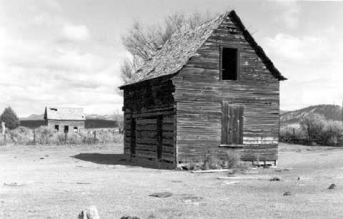
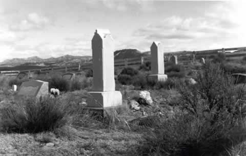
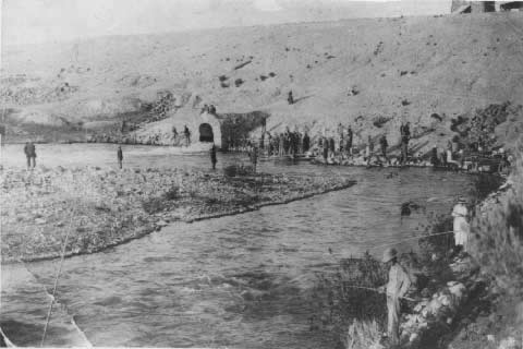
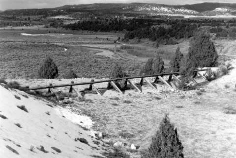
between St. George and Las Vegas. As for Flake Meadow, picked up in some of the dust of western history, the people there
began to talk about a dam many years ago, even before time closed the books on the 19th century.
Asay died with a cold in the head and Hillsdale was waterlogged each spring, and parched every
summer, and finally left for dead (see Photographs 1 and
2). But Hatch Town has held out. Hatch TownNot until the late 1870s or early 1880 did the second family settle at Mammoth Creek to be
Meltiar's neighbor. Neils Peterson Clove came with his wife Sophia Rasmussen and "raised lovely
gardens south of the high rock ledge," Effel Riggs wrote. "Grandma Sophie wore wooden shoes,
but she went barefoot when she worked in the garden." As for Neils, he was a shoemaker by trade,
but finding few shoes to repair in Mammoth Creek, he turned with typical 19th century
versatility to working with lime. In a wild, primeval land it was exciting enough to meet new people or old friends in and out
of Long Valley and Dixieland, to say nothing of the Muddy Mission folks. They did not always
await a "call" from the General Authorities before making moves of their own. Dissatisfied and
one hundred percent American, they were free to seek land in the public domain elsewhere, even
to seek supplementary homesteads, and such were the Asays, who, coming out of the Muddy Mission,
settled first at Mount Carmel (Winsor), and then went to Asay Creek, "close" neighbors to
Meltiar Hatch and Pete Clove. Asay, Utah, lasted until 1900, but the land looked promising enough at the beginning, when
Brother Joseph Asay staked out some squatter's rights in 1872 on land along the creek that
instantly bore his name. He called his place a "ranch," as Metiar did his, and he intended a
summer residence on it, to return each winter to Mount Carmel. Brother Joseph was a fisherman,
and a cool, clear mountain trout stream was his concept of the Celestial Kingdom. Joseph brought his whole family to Asay Creek, including everyone of his 10 children. In
1877, Sarah Ann wrote her feelings on a piece of paper: "The weather is getting warm now. We
have had a very cold spring. Our wheat looks fine." Simple. But it meant something to her, and
there is feeling in her apparent need to jot it down. In 1880, the census could count six families residing at Asay, out of which two were named
"Asay." In 1887, a post office had been established at Asay, Utah. It was in a long house, and
for a while it was also the post office for Hatch Town. Farming, livestock raising, and lumber
milling provided Asay with enough livelihood to make the little community possible. Asay reached
its climax when a log school house was erected just west of the present highway (U.S. 89). The
school building was also their church. It was the second school in the uppermost basin of the
Sevier River, even ahead of Meltiar's Hatch Town. The first school house was at Hillsdale, about as far north of Hatch Town as Asay was south
of it, which means to say about six miles. Hillsdale was also about 100 feet lower in elevation
than Hatch Town. The reason for any school, of course, is the presence of children, and children
arrived in Hillsdale in 1872, which was only one year after George Deliverance Wilson and Joel
Hills Johnson arrived there from Long Valley, looking for water power to run their mill and a
supply of timber near enough to saw in it. They found the site about eight miles north of Hatch
Town. Wilson was a Muddy Mission pioneer. Johnson was one of five brothers who had settled in
southern Utah in 1850: Joel Hills, Benjamin, Joseph, George, and William. It shouldn't surprise
that they called their "hometown" east of Kanab "Johnson." Millwrights were among the tradesmen most sought after in the process of settlement in
pristine western America in the 19th century. Lumber production became the first and the main
industry at Hillsdale, but farmers and livestock men began to arrive after 1872. Bishop George W.
Sevy of Panguitch spoke with President Brigham Young, and President Young counseled people in
Panguitch Valley to survey a townsite two miles upstream of the mill. Such approval by
ecclesiastical authority was bound to bring settlers, and 35 families answered the "call." Thus
agriculture began to supplement milling. Most of the settlers were named Wilson or Johnson,
related to George Deliverance and Joel Hills. With a few years, others came to make Hillsdale
the largest community along the road south of Panguitch. Panguitch itself was resettled in 1871,
after having been abandoned for Indian troubles about seven years before. The community of Hillsdale was named in honor of the "Hillses," Hills being Joel's mother's
maiden name. Between 1879 and 1884, there were 42 names listed in the Hillsdale ward ledger,
presumably the names of heads of families. By the 1920s, Hillsdale had been struck by enough spring floods and economic problems, and
by the habitually dry summers to look extinction in the eye. Dry summers meant not only minimal
water for irrigation, but also insufficient water for its mill-runs. The collapse of dams at
Hatch Town in 1900, 1901, and 1914 provided eloquent advance notices of mortality. Occasional
cloudbursts on the Paunsagunt Plateau, especially an unusually severe one out of Procter Creek
in 1921, provided Hillsdale with a series of coups-de-grace. Land and water rights in Hillsdale
and in its surrounding fields were gradually sold, range animals were allowed to run in former
farm fields, and summer homes were abandoned. Joel Hills Johnson was encouraged to leave as early as 1883, returning to Johnson, in Kane
County. George Deliverance Wilson died at Hillsdale in 1912. All that is left of Hillsdale today
is a cemetery and some remnants of human habitation occupied by a family or two and some
memorable, nostalgic ghosts. A few people still clung to Hillsdale as late as the 1940s, even
attempting a motel business, but the last known schoolmarm was Alice Wilson, in 1925-26, and
when the children are not enough for a schoolhouse, the cemetery begins to loom larger than the
town. Emerging out of its beginnings as a ranch for Meltiar Hatch, Hatch Town became the only one
of the three communities founded in Panguitch Valley south of Panguitch to survive. It is not
immediately obvious why Hatch, with the same climate and on the same flood-prone river channel,
lived on where its neighbors died. Meltiar's historic start was not necessarily a determinant
factor, and for a while Hatch itself may have teetered. Perhaps the answer lies in the presence
of potential dam abutments at the north end of Flake Meadow. In 1889, the United States
Geological Survey conducted a territory-wide exploration for damsites in Utah, and one of the
13 most promising places they named for a dam was the Peterson homestead on Flake Meadow. From
at least that date henceforth, Hatch was considered one of the most likely places to construct
a reservoir and a dam. If this at first did not provide all the motivation to live and grow
there, the promise of water did prevent the evacuation that eventually occurred at Asay and
Hillsdale. The most immediate and most encouraging about the promise of a dam, of course, lay
in the role of the reservoir as a means of spring flood control and as a source of irrigation
water during the dry months of June, July, and August. There was reason to think it would also
prevent contention with Panguitch water users over allocation rights. As for recreational use,
it is reasonable to believe that Hatch Town residents also considered the reservoir that would
result from a dam as a place to fish and to swim. After Meltiar and Pete Clove, the little town of Hatch took a few years to acquire 100
people. Most of the increase came from southern Utah, no few of them out of Dixie and Parowan
and a quota from Asay and Hillsdale. Even in the days of Meltiar Hatch and Pete Clove, however,
a few settled on the site who in a few years changed their minds, and, leaving log cabins
standing departed for elsewhere. One may presume that the cool weather changed a lot of minds.
Despite the problems attendant upon travel in the 19th century, moving about seems to have been
the order of the day. People moving in and out of Hatch Town are hard to track down today, now
that trails have cooled and have blown over with historic dust. Nevertheless, in-and-out of
Hatch Town, there are some that can be recognized as historic "Hatch names": Hatch, Riggs,
Workman, Sawyer, Clove, Burrow, and Barnhurst. Few would dispute the name of Asay there, or
Barney, Huntington, some Wilsons, an Allred, and a Swedish Anderson. Some, such as Jacob
Lindsay Workman, lived out of town (e.g., five miles up Mammoth Creek), but they still
considered themselves part of Hatch Town because that was where their church ward membership
was recorded. Acquiring culinary water was always a serious problem for Hatch Town. Originally clustered
on the Sevier River banks below Flake Meadow in order to be as close to water as possible,
numerous supplementary ideas were put into operation involving wells, springs, and hauling
water into the community in barrels. Such plans involved hard work and desperation. Snow water
was used in season, and irrigation water was used for laundry purposes. When the town moved above the Sevier's floodplain in 1901, the problem did not change. If
anything, it intensified once they were removed away from flood danger. The problem was not
solved satisfactorily until after the town was incorporated in 1934, after which, having
acquired the power to tax, running water came to Hatch through pipes out of the high reaches of
Mammoth Creek. This was not until 1944, and at that time there were 54 families living in
Hatch, which, allowing and an average of 4 children per family would equal a population
somewhere between 200 and 300 people. Hatch Irrigation Company was organized in 1902, but competition with incorporated Panguitch
for irrigation water was debatable until after a lawsuit settled allocation problems legally.
Thoughts were focusing on a third effort to effect a dam at Flake Meadow and how water should
be distributed once the State completed the dam. There does not seem to have been the same kind
of intense litigation in this area as there was downstream, as between water users of the Piute
and Sevier Bridge Reservoirs. Probably, this was because Hatch never became large enough to
threaten water supplies at Panguitch and Panguitch was able to draw water from elsewhere. Hatch, Utah: 1894-1902After the United States Geological Survey's inclusion of Hatch as one of thirteen favorable
sites for locating dams, the historic period between 1890 and 1914 witnessed the construction
of three of them. The principle was good, the efforts were heroic, but so far, because of the
engineering was careless, the dismay has been profound. A History of Garfield County says that "In the summer of 1894-95 work was started on
the excavation of (the Hatchtown Dam) ...This work was continued and completed during the '90s,
and in February 1900, the Upper Sevier Reservoir, Irrigation and Fish Stock Company begun (sic)
the construction of a dam across the Sevier River about 11/2 miles above Hatch, and about 20
miles south of Panguitch." The faults must have been many in crucial sections of the dam. Workers barely got the earthen
dam in place before leaks developed. Shortly after completion the dam caved-out and a lot of
dreams flooded downstream. A wall of water roared through old Hatchtown, Hillsdale, and on to
Panguitch and beyond. No lives were lost in that springtime of 1900, but there was some property
damage. A part of Eleaser Asay's shed and a barrelful of salted fish he had stored were carried
off. With a modicum of old rural Utahese, one may say, "It dint take no hurt." One may say it,
that is, if wiping out canals and ditches, Eleazer's shed, and a full barrel of salted fish
are "no great hurt." At this point one thinks of the beaver, which, whenever his engineering fails, has some kind
of tribal meeting and directly afterwards starts all over again on a new one. Perhaps Hatch
subconsciously borrowed its spirit from the beaver, for the Paunsaugunt Plateau east of town
was named by the Piute, and it means something like "the country where beavers live." A man has
to have a little beaver perseverance in him to thrive in a land that stands on end and
experiences rushing waters. By May 1901, there was already a second dam in the place of the one that had just blown out.
This one was even a little larger, but nobody remembers much about the first one, since it
washed out so quickly. The second dam at Flake Meadow was 40 feet high and 20 feet wide. I
don't know how long the spillway was, but it was four feet deep in the center of the dam and
spilled water over its crest to about a one-foot depth over a rock-covered face. If the
builders were not complacent, their hopes rode a little higher than they had a right to. But
somebody in Hatch Town took a look at the dam and there was something in it that caused him to
suggest to other people there to move the town. They talked about it without hysteria, and they
thought it would be wise to move the only homes they had to higher ground. In their vernacular,
they "counseled" with one another. Unincorporated, their secular business was handled by their bishop, Rosmus Lynn, and his two
counselors, William R. Riggs and Samuel J. Barnhurst. Acting in trust for the citizens of Hatch
Town, Garfield County, they made legal arrangements for the entire town to be moved uphill and
out of the flood plain, recalling as they did Eleazer Asay's shed and his barrel of fish.
Log-by-log, board-by-board, and (one supposes) brick-by-brick, they moved Hatch Town north, out
of reach of the river and about one mile from the site of original Hatch Town. "...down along the
river course, across the Sarah Wash drainage. then up over Alger Hill and down through the now
south field." was the route they took to move their homes and other buildings, according to
Effel Riggs. But the land on which they moved was United States public I domain, and some unusual tactics
were employed in their feeling of emergency. Exercising some kind of "squatter's rights," they
moved instantly and effected the necessary legal documents later: (1) somebody in Hatch Town
had to become legal owner of the new site, and then (2) the site had to be made available to the
unincorporated town's trustees through (3) a legal compensation clarified in a warranty deed.
Thomas Ball Sawyer ("Tom Sawyer") and his wife Margaret Sawyer patented a homestead claim that
was signed by President William Mckinley on 13 July 1901, which was about a year or so after
the town had been moved to the claim. Following that formality, Tom and Margaret Sawyer signed
a warranty deed, witnessed by Riggs and Barnhurst, making the Sawyers officially the grantors of
the land to Hatch Town for one dollar in compensation (plus some other "unmentioned
considerations"). The Sawyers thus "established and duly consummated" their homestead "pursuant
to an Act of Congress approved May 20, 1862, to secure Homesteads to actual settlers on Public
Domain." This procedure was not in the usual order, but everybody seemed to understand the need,
including the President of the United States, a couple of Uncle Sams (U.S.A. and Uncle Sam
Barnhurst). It could not have been any more American and folklore-like than to have it signed by
"Tom Sawyer." The fact that the order of procedure was reversed in the transaction was a happy
instance of man's humanity towards his fellow man. The fact that they "threw the cow over the
fence, some hay" seems insignificant. "New" Hatch Town lived on borrowed ground, it seems, for a time, for the warranty deed was
not filed until 30 January 1902. This was about 11/2 years after the town had squatted on Tom
Sawyer's homestead. But wisdom superceded legal formalities in May 1901, when the second dam
uncorked. The sequence of events after the break of the first dam was almost uncanny: break of first dam, spring 1900
decision to move Hatch Town, summer 1900
break of second dam, May 1901
patent of Tom Sawyer's homestead, July 1901
warranty deed witnessed, January 1902
Not only did more water pass under the bridge that crossed the Sevier River south of "Old"
Hatch Town, but in May 1901 it passed over it, through it, and distributed it downstream as far
north as Junction, 50 miles away. That happened just a few weeks before the first irrigation
water was to have been released on June 1. Spring runoff filled the reservoir to capacity; then
the winds came with extraordinary violence, churning the reservoir lake into a nasty, miniature
sea. The engineering mistake became evident when water splashed over the crest of both the dam
and the spillway, washing it out by topping it. Due to an inadequate height, the water crested
over the dam and in a very short time took the entire structure, aided and abetted by wind and
wave. It was only by the best of luck and hurried warnings sent downstream that, again, not a
single life was lost, not even among those struggling on the crest of the dam to build it up
belatedly. The roar of water and collapsing materials was possibly the only sound discernible in that
terrible, sickening moment of despair and frustration. It is possible that men yelled, women
screamed, and perhaps children cried. But I doubt it. The ensuing mood must have resembled the
aftermath of punitive acts by an occupying foreign army; in the wake of sudden brutal action
there is often a cold, deadly silence. Even if some yelled, screamed, and cried, such exhibitions did not tarry. Utah was settled
here and there amongst tears, but the territory, north or south, was never based upon them.
After counting the Asays, the Barnhursts, the Riggses, the Lynns, and all others, big and small,
old and young, and finding that everybody known to have been present in "New" Hatch Town was
still around and probably cursing the water running amuck over their irrigation ditches, they
decided to be grateful that somebody had "tipped" them off a year before. watching the Sevier
River's flotsam and jetsam roll by in the swell of water, this would have been a logical time
for the weak and irresolute to walk away. Nobody did; at least, not obviously for reasons
related to the Sevier River. It may have been different at Hillsdale, where even before 1890 people had moved for reasons
of discouragement. It had been better than losing part of your family to an Indian warparty or from hunger or
fatigue. It was better than that, maybe, but it was not good. The best anybody can say for
floods out of broken dams at Hatch Town is that nobody died in them. The faith was intact,
charity was around, and when the sun came out again in July and dried the bottoms of the
floodplain, hope rose again: hope, that thing which if you are free to act on it makes you feel
like an unfettered man, woman, or child. They started thinking again about a third dam. They are superbeavers in Panguitch Valley,
which includes Hatch Town. They resemble the opera singer who receives encore after encore for
his efforts before an Italian audience, to do his piece again, again, and again, until, thanks
be to God, he gets it done correctly! Although Hatch Town was the site of the proposed dams, it was mainly communities downstream
that would have received most of the benefits. Besides some irrigation water and spring flood
control protection from a successful dam, Hatch would have gained a nice swimming hole, a
skating rink around the edges of the lake, and maybe a place, as they say, "to drown a worm"
occasionally on the end of a fishing line. But it seems that Hatch Town thought a little more
possessively with the dam than the benefits justified. It was their dam. It gave them
some distinction, it had their name on it. A casual visitor there becomes impressed that they
feel a little personal about it. Maybe (who knows for sure) the town was thinking
about a third dam to bear their name that prompted them to be concerned about a new christening
for themselves. There wasn't much feeling anymore for the historic "Hatch Town," or "Hatchtown."
Not long after their second experience with a dam break they began to debate about what they
should call "New" Hatch Town. They were still grieving the loss of the second dam, but it was as
though twins had been born and one of them had died. It was as tough as eating shoeleather to
bury the one that died, but you couldn't forget for all of that to christen the other one, cry
as you may have over the one that expired. In 1900, they were still pretty much frontier people, no matter that up at the State
University in Salt Lake City history professors were professing to know that the frontier had
ended in 1890, and no matter that the Daughters of the Utah Pioneers said you couldn't join
them if your genealogy arrived after 1869. That was the year the transcontinental railway was
joined at Promontory Point, but what was the importance of that to people settled almost 300
miles from that place? Minnie Lytle wanted to call the new town site "Sunset." She was romantic about the evening
hours there and the beautiful twilights. Priscilla Riggs suggested "Fairview" in somewhat the
same spirit, but people reminded her there was already a town by that name in Sanpete. "Old"
Hatch Town had often been called "Mammoth" by some people, and somebody wanted to make it
official. Somebody remembered that there was a mining town in Juab by that name, and anyway,
after two out of two dams had washed out right under their very eyes, they didn't feel so
"mammoth." It didn't make them feel any more mammoth after counting noses and came up with less
than 200 of them, man, woman, and child. Jobe Hall almost settled it. "I still like 'Hatch'," he
said. There was no other town in utah with the same name, although there were many people by
that name in Utah. It was not really settled until they spoke to one of the general authorities of the Church
about it. Francis M. Lyman told them he thought it ought to be just plain "Hatch"--not "Hatch
Town" or "Hatchtown," but plain "Hatch," as in Meltiar. It then seemed that Jobe had had his
head on straight. "Hatch, Garfield County, Utah, U.S.A." Effel Riggs called her book, The History of Hatch, Utah and Associated Towns of Asay and
Hillsdale. "'Old' Hatchtown got washed away," she told me. "It's 'New' Hatch up here, out of
the Sevier bottoms." She said something like that, and she ought to know. It's "Hatch." In the springtime we watch for the buds to swell on the trees, the
yellow dandelion to push its head through the melting snow. .The summers are delightful, with
high temperatures only in the 80s ..Autumn is a time of fulfillment with the harvest in and
nature's painting calling for a day in the canyons. Winter, if we are fortunate enough to get
snow, is filled with. .sleighing, coasting, tubing, and ice skating in fields and meadows. ..
The north wind dies down with the setting of the sun and peace comes over the valley and the
lights shine from each neighborhood window.
Three DownCertain acts of the Congress of the United States inspired the State of Utah to suddenly
focus its attention on Hatch. Before 1847, the territory which now includes Utah was Mexican.
But in February 1848 Mexico ceded all of the land it still possessed west of the Mississippi to
the United States. It became American "public domain." It was the purpose of the United States
to make as much of that land as possible available for settlement by American citizens. Methods for transferring ownership of arable lands in the West became complicated. The first
homestead act was passed in 1862, followed by the Desert Land Act of 1877. These confused more
people than they enlightened, and this fact aroused interest in favor of state and territorial
participation in the process. The Carey Act of 1894 was the result. under this legislation the
United States donated lands to the various western states and territories in limited amounts,
provided that they assumed responsibility for the irrigation projects that would encourage
settlement of hitherto desert, dry lands. At first Utah was disinterested because few state
officials saw much need for reclamation projects. It took the Reclamation Act of 1902 to get their attention. Rooted in Theodore Roosevelt's
Conservation Movement, the Act had a hard time making it through the closed ranks of a Congress
dominated by Eastern interests. But President Roosevelt must have swung his big stick,
accompanied by not so soft words, for the Act made it. It was administered by the Reclamation
Service of the U.S. Geological Survey until 1907, when a commission to administer it was
organized separately. In 1923, this Commission was incorporated into the Department of the
Interior as the Bureau of Reclamation. The Carey Act and the Reclamation Act combined to make cooperation feasible between the
states and the federal government. Succinctly this is how the State of Utah talked itself into
entering the real estate business shortly after the turn of the 19th century into the 20th. Once
they had some time to think it over and act on it, state officials entered into the project with
zeal and dogged determination; one might even say, with all tails wagging. The Utah State Land Board directed a publicity program aimed at national attention. Utah had
become a state only a short time before, in 1896, and its Land Board "knocked itself out"
calling the attention to the rest of the states to its existence. The productivity of Utah's
land and the friendliness of her people were combined with discussions of generous terms on
sales. In order to make their "pitch" plausible, of course, knowing that Utah was a desert, it
was necessary to explain where water in Utah comes from and to promise to develop the kind of
engineering projects that would lead water to the land. It was done through magazine features,
in news articles, in speeches, and in pamphlets and brochures. Officials in Utah, of course,
anticipated good to come out of it all for the State through an improved economic status, and
perhaps, with a greater population, a little more clout in Congress. The floodwaters out of Flake Meadow had hardly dried in the mudcaked lands between Hatch and
Circleville before the State began buying land, rights, and necessary easement for the third
attempt to dam the Sevier River at Hatch. The State still referred to the community as "Hatch
Town," or "Hatchtown," but in the State Engineer's Report of 1906, and in the Report of the
Secretary of the Land Board in the same year they publicized information pertaining to intended
land purchases. Officially, they called it "The Hatchtown Reservoir Project." Little time idled
away before the State signed a contract with D.W. Brinton Construction Company of Draper, Utah.
Signed on July 18, 1907, the contract stipulated completion of a dam by December 1. For the
canal that would lead the water to lands intended for irrigation, time was allowed until May 1,
1908. But things ran a little more slowly than anticipated. Everybody moved as swiftly as they
could for those days of hand-shovels, horse-teams, horse-powered scrapers, and wagons. The
State Engineer's Report for 1907-1908 tells us that the reservoir was completed November 30,
1908, and the gates in the dam were shut for winter and spring collection on December 2. The
20-mile-long canal was completed shortly after the reservoir, and it was planned to have the
diversion dam on the Panguitch benchlands done before the irrigation season of 1909. "There is no question," said the report, "that the State will be amply able to deliver
sufficient water to irrigate 5,800 acres on the Panguitch east bench, which has been selected
by the State to be irrigated by this project, and is to be sold at auction to reimburse the
State for the expense of the storage works at Hatchtown and the diversion dam and canal at
Panguitch." Land was to be sold in 40-acre tracts, @ $20/acre, minimum. If any 40-acre tracts were sold
that were not wholly under the canal, any such dry land would sell @ $2.50/acre. All land
unirrigable for other reasons would sell at the same price per acre. Terms were generous, as
promised in pamphlets and brochures. Nothing could be done elsewhere on the Sevier at this time, the State said, because of a
larger undertaking called "the Piute Project," below Junction. This project was to benefit
similar dry homesteaded lands in Piute, sevier, and sanpete Counties. The Hatchtown Reservoir Project enabled the State to sell 6,000 acres of land on the
Panguitch east bench, mostly to people from outside the State of utah. The majority of them
were from "the Missouri River Valley," which one must interpret to have meant mostly from the
State of Missouri, Kansas, and Nebraska. The third Hatchtown reservoir was to be the same size as the second (about 12,000 acre-feet),
but recalling the overtopping of the dams and spillway of the second, the new plan called for
the third to be over 100 feet longer and about 20 feet higher. The bulk of the dam was to
contain 126,000 cubic yards of packed earth and hard rubble rock. The spillway was designed to
be 150 feet long and set six feet into the crest of the dam. It was to begin about 200 feet
from the southerly (or right side) end of the structure. The dam was originally designed to be
20 feet wide at the top. The outlet works were 200 feet from the northerly abutment (or left
side), constructed of "rubble masonry" into a single arch 320 feet long. It was five feet wide
and eight feet high. Plans put the third dam in precisely the same location as the second, and
its culvert was almost in the place as the preceding one. Water in the culvert was to be
regulated by four gates, each one of cast iron and each one four feet by four-and-a-half feet
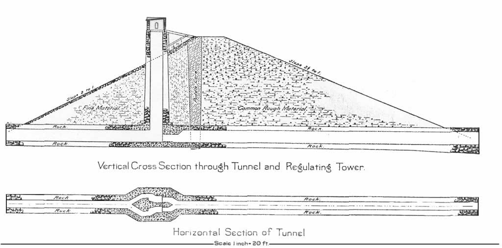
in dimensions. Controls for the gates were planned in a square tower upstream of the dam,
accessible from the dam's crest by planks. The tower itself was to be constructed of rock into
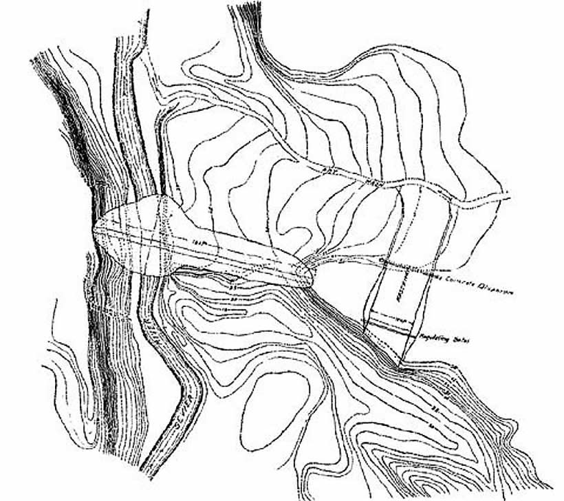
a 12-foot x 12-foot cube (see Drawing 1). Specifications became modified somewhat at sometime during the actual construction. Instead
of 150 feet of spillway, only 80 feet were built into the dam, and instead of the planned width
of 20 feet, the dam's width at the crest was only 12 feet (see Drawing 2). 
Drawing 1. Cross section (through the tunnel and regulating tower) of the Hatchtown Dam as designed.
 | Click on the image for a larger version. |

Drawing 2. Engineer's drawing for the dam at the Hatchtown site. Note the spillway located in the eastern abutment.
| Click on the image for a larger version. |
For much of the rest of the story one must return to Hatch and the people who lived there at
the time, between 1906 and 1914. Although Hatch was not in line to receive much irrigation water from the reservoir itself,
the geology and the geography of the site provided the most adequate conditions for the
abutments. Despite the minimal irrigation benefits accruing to it from the dam and its
subsequent canals, Hatch nevertheless participated in the reservoir construction and in its
protection. Being named for Hatch, the dam gave the little community recognition not attainable
by its history alone. Moreover, Hatch saw some benefits to be gained that were of a more
substantial nature. A reservoir is a lake, and lakes can be places of recreation. Perhaps
there would be a little boating, and no few of the men of Hatch enjoyed fishing. If the water
was too cold for swimming most of the time, perhaps there could be some ice-skating during the
long winter months. (On December 7, 1912, a 12-year-old boy Jim Marshall tried skating across the reservoir,
instead of staying along the shallow edges, where he had been told to. Even in December the
reservoir was deep enough to drown him when his weight broke through a thin place. In a tight
little ship like Hatch the loss was felt as some kind of surgery on the body of the
community.) Many of the workers and their teams of horses and equipment that were used in constructing
the dam were from Hatch and its vicinity. Through hard labor and wet feet the men of Hatch and
others who moved, scraped, and stirred the earth and rubble of the reservoir became well
acquainted with the physical nature of the site. when Ernest Hancock, a teamster, noticed a
lively spring of water at the projected left abutment of the dam he did not hesitate to call it
to the attention of his supervisor. He recommended to the supervisor that the abutment be moved
either above or below the spring. Several others who had noticed the same thing echoed his
recommendation. But they were not engineers. The supervisor replied that in his opinion the
spring was not big enough to cause concern. "(It was) at the base of the black ledge just west
of the Sevier River," Effel wrote in her book, "(where) water comes out quite generously and
watercress grew profusely." In 1907, the superintending engineer and the contractor had harsh words, the engineer
contending that the contractor did not seem willing to carry out the original job
specifications as designed, being neither financially able nor adequately equipped. Nobody
came to blows, however, and the dispute was settled enough so that work went on apace in 1908.
Some labor problems over pay scales rumbled a little but nobody struck his job. The climate of Hatch had something to say about the job during November and December 1907,
when the ground at the site froze solid, and the superintending engineer found it impossible
to protect the culvert masonry from frost damage. All he was able to do, however, was wait
until spring. Leon Sawyer told how the ground at one place in the bed of the reservoir was so swampy that
workers could not get into it to excavate. They also mentioned quicksand nearby. Its location
was apparently crucial enough for the dam to worry his foreman, who tried to stabilize it with
straw and manure. Other than clean out some of the corrals in Hatch, however, nothing was
gained from that. Completed in the fall of 1908, the dam was ready for use in 1909 (see Photograph 3). During the spring of 1909 all four outlet gates in the culvert jammed. Controlling devices
refused to budge even when four men applied their strength to them. The caretaker of the dam,
Alexander W. Huntington reported it to the District Engineer, Caleb Tanner, in Richfield, who
called the State Engineer Joseph Jenson, who, as the original designing engineer had installed
his gates, known as "Jenson Lock Gates." Mr. Jenson replied that he would have to "go down and
show the country guys just how to do it." This he did, although in 1909 it took a train ride
to Maryvale and some kind of horse-drawn vehicle to travel the 60-odd miles from Marysvale to
Hatch. When the city guy couldn't turn the wheel any more than the hick, Mr. Jenson arrived at the
conclusion he could loosen the gates with a smidgeon of dynamite. That should have raised a few
eyebrows in the whole Panguitch valley, but farmers and laborers are not inclined to debate with
civil engineers. It was springtime. Flowers were beginning to show, even at Hatch, and life was becoming balmy.
Farmers were leaning on their shovels at their head-ditches, waiting for that life-giving water
to fill their furrows, soaking the land and swelling the seeds they had planted not long before. Collectively and individually, abstractly and instinctively, Hatch remembered 1900 and 1901,
and when Mr. Jenson mentioned "dynamite" there is undocumented subtle evidence that their eyes
all lifted together unto the hills, in both expectation and in song. Somebody recommended that they get 01' Dunip Dickenson, the powder man at the mines in
Maryvale, and get him to set the sticks. They went to get him, and he came down to Hatch in a
two-seated buggy. Oliver Huntington was nine years old at the time, and being the son of the
caretaker, Alexander Wiley Huntington, Oliver was naturally interested in what was going on. He
watched as Dunip counted out 65 sticks and as Dunip and another man carried them into the 5 X 8
culvert tunnel, he followed them at a distance, unknown to the two men. Somebody had suggested
that Dunip climb down through the tower to the gates, but apparently Dunip was all there; he
preferred walking the 300 feet of the culvert in a foot of water with enough length of fuse to
allow climbing a ladder in a hurry. Each man carried a kerosene lantern into the darkness, which
at an undetectable distance was all Oliver needed to follow along. Dunip had placed his 65
sticks and had fixed his fuses and was turning with the other man to get their hides out of that
tunnel, when he discovered Oliver right under his feet. "If you don't move fast," Dunip told
Oliver, "I will kick the hell out of you!" Oliver moved fast. In those days youth had respect
for their elders. All three of them ran like antelope out of that culvert and made it all the
way to the black ledges before the dynamite went off. The entire dam quivered, and the tower danced a little. But Mr. Jenson's dynamite unstuck the
gates. Water rushed out of the culvert and into the canals and ditches and furrows, and 10!
everybody had a crop that year, and if they didn't it wasn't the fault of the State Engineer
Joseph Jenson. Not that year, anyway. It is not clear what happened to Oliver when Dunip Dickerson told Alexander Huntington where
Oliver was when the fuses were lit and the powder placed. For a few minutes Oliver was probably
an abused child. In 1910, the reservoir in May was nearly up to full capacity, and under pressure some seepage
was noticed along the right side of the downstream "toe" of the dam, about 230 feet below the
crest. Some sloughing was caused there. It was checked by piling a heavy bank of rocks against
the slope at the place of seepage, but this act was not officially entered into the records of
the dam. Some repair work was done on the upstream face of the dam during 1910-1911, as well as
some repairs on gate bearings, which the assistant engineer said were supported by cement of
poor quality. The seepage was noticed in three successive years: 1911, 1912, and 1913. There
were some cursory examinations, and after each inspection the problem was declared
insignificant. On April 15, 1914, water at the Hatchtown dam stood at 35 feet, representing at that point
almost 5,000 acre-feet in the reservoir. Water deepened to 41 feet on May 5, to 47 feet on May
10, and 52 feet on May 22. It does not seem to have been an especially big water-year, for by
May 25 water at the dam had not gained much depth since May 22. It broke anyway at 8 p.m. on May 25, and a wall of water 10 feet high rolled through the
flour mill at Panguitch in two hours. Houses and outbuildings in its way were tossed around
"like eggshells on the foaming waves," according to the Panguitch Progress of Friday,
May 29. Hatch warned its neighbors by telephone as early as 2 p.m. that it was going to happen
again. The operator in Panguitch Alice Syrett stayed at her post until the wires were swept
away, calling everybody she could in and around Panguitch and below Panguitch as far as
Circleville and Junction. Between Hatch and Panguitch the Sevier River drops 321 feet, or almost 22 feet per mile.
When the third dam broke at Hatch in 1914 the velocity of water rushing towards Panguitch and
farther did a great deal of damage, and in 15 miles (or 18) gave very little warning. Only with
the greatest of luck was a loss of human life avoided. Damages were measured in terms of dollars
and cents only and in interruptions of communications. The wall of water released in the 1914
disaster at Hatch emptied the reservoir south of Hatch in a matter of three hours. A wall of 10
feet of water representing about 8,000 acre-feet did hundreds of thousands of dollars worth of
damage as far north as Junction, but, because there had been advance warning, everybody was
dismayed, but not surprised. The piute Reservoir, being only partially filled at the time, took
the flow out of Hatch easily. The Ninth Biennial Report for 1913-14 of the State Engineer's Office provides the
following information: ...the reservoir was barely filled to the sill of the spillway when the
break occurred on May 25, 1914. Mr. Hunington, who was on duty as watchman at the time the dam
failed, described the conditions as follows: During the forenoon of May 25 I went over the dam and did not see anything out of
the ordinary, normal conditions seeming to prevail at that time. About 2 o'clock p.m. a Mr.
Clark, who had been staying with me, attempted to cross the dam when he discovered a stream
of muddy water about the size of a stovepipe coming out through the downstream face of the dam
along the east side of the culvert at the bottom of the sidewall. This stream held steady for
about two hours and then started to increase. The ground above it began to cave, first in small
slabs, then large, until the opening was about 30 feet wide and to within 60 feet of the water
line on the farther side of the dam, when the dam gave way and a wall of water 52 feet in height
rushed through the opening. This occurred at 8 o'clock p.m., and at 11 o'clock p.m. the
reservoir was practically empty, three-fourths of the volume having gone out in the first
hour. ..I, with some of the men of Hatch, tried to discover where the water was entering the
dam to stop the water with manure, straw, etc., but we were unable to determine where the water
entered the dam.
On May 23, 1914, E.A. Porter, District Engineer of the U.S. Geological Survey, visited the
Hatchtown Dam. He . .took a picture of the dam, and. .there was no seepage along the downstream
toe. .the dam looked to be in good condition. .a high wind was blowing from the south. On May 30, 1913, I visited the site and found that the dam was a complete wreck, there remaining
only two ends of the embankment. when the dam failed it carried with it every vestige of the
culvert and control works, and exposed about 200 feet of the base of the old culvert, built by
the Upper Sevier Reservoir, Irrigation and Fish Stock Company, which had not been removed from
the damsite when the State dam was built. ..I am led to believe that the failure of the dam
have (sic) been due to any one of the following causes: (1) poor foundation (2) poor design of
culvert and control works (3) development of additional springs in foundation of the dam, due to
increased irrigation on the benchland west of the damsite.
The Deseret News reported on May 27 that water at the Piute Dam was measured hourly on
the day before with the following results: noon - 62.86 feet
1:30 - 63.76
2:30 - 64.16
3:30 - 64.56
4:30 - 64.96
5:30 - 65.26
6:30 - no reading
7:30 - 65.71 feet
8:30 - 65.91
9:30 - 66.02
Water depth at the Piute Dam rose an average of 0.11 feet per hour. Panguitch and Circleville
were reported under water, but Junction was dry. One thousand people were estimated to have run
for higher ground. Fourteen diversion dams between Hatch and Junction were washed away, as well
as an uncounted number of bridges, the Syrett residence in Panguitch, a farmhouse in Hillsdale,
and the Robinson ranch buildings near Circleville. At Junction the Sevier River flowed by a
mile wide. The carcasses of numerous dead animals floated into the Piute Reservoir.
Miraculously, again no human lives were lost in the ordeal. Ten-year-old Ernest Riggs at Hatch picked up a loaf of bread his mother Priscilla had just
baked and ran out of the door with it, heading for the hills west of town. "Where to?" his
mother asked, in effect. "I don't want to drown and I don't want to starve either," he told her. It's called
strategic retreat, but she called him back to reassure him. Hatch, she told him, took care of
that between 1900 and 1901, a few years before Ernest was born. He knew about it from hearing
older people talk, but Ernest at the moment was caught up in the fright even above water level.
When he calmed down he ate his bread at home, and he didn't drown either. Disasters are bad, but they have a tendency to test people. It was the old names out of
Dixie, the Muddy Mission, and out of Eagle Valley that stayed on in Panguitch valley after 1914.
It wasn't because the "natives" enjoyed watching dams break and seeing other people run for the
hills. It was home, and when your home is hurt or destroyed you don't easily leave it--you fix
it up or you start again. At least, that was true in 1914. Not even Hillsdale called it quits
yet. But the "show-me" folks from Missouri, they who had come to an irrigated promised land, they
departed, never to return. They were scared and they were good and angry too, and, of course,
nobody blames them. Furthermore, they wanted their money back. Red-faced about it, the State of
Utah paid them back. The State also admitted it owed something to everybody in Garfield and
Piute Counties who had been hurt by the failure of the dam at Hatch. But thank God and the engineer of the Piute Dam. If that hadn't held, it would have been
"goodbye" to the Sevier Bridge Dam at Fayette and that would have meant "hello" Lake Bonneville! A "Pageant of the Spectrum"There were a few people in Panguitch Valley after 1914 who said they had had enough. After
that third dam blew out, they simply became what soldiers become after too many days on the
firing line--a little shell-shocked--or is it waterlogged? Just the same, most people in the
region were talking fourth-dam before they even got all the water sponged-up. Maybe there is a
little general nervousness every time they hear an engineer say it would really be safe these
days, but there is no discussion in progress for a contemplated dam site anywhere but Hatch. From a historical point of view, Dam Number 3 now appears to have established a little
different kind of high watermark: a climactic point in history in the Panguitch valley in
general, and in Hatch in particular. Although everyone wishes the third dam had remained intact,
one is as certain as one can be in historical speculation that even a successful third dam would
have had to be modernized to meet changes in these years now approaching the 21st century. The
unhappy ending in 1914 saved a great many headaches that would otherwise have been involved in
the remodeling, or even reconstruction, necessary for the "lifestyles" of 1985 and beyond. In
the first place the failure of Dam Number 3 ended a period on the Hatch site of what one is
tempted now to call a "period of impulsive dam building." It was a period at Hatch that featured
cursory testing procedures and casual analyses and even more careless designing (see Photographs
4 and 5). The failure of the third dam and the subsequent long waiting period before serious
consideration of a fourth, also coincided historically with a period of increased awareness and
interest in the magnificent scenic resources of southern utah, in which Hatch finds itself in a
geographic function area between 3 national parks and various state and national monuments. In
this setting, some significance has been added to the location of Hatch which underlines
advantages perhaps equal to or surpassing the construction of a new dam. It was not until 1914 that the people of Dixie began to see their lands through esthetic
eyes, and that was a full 42 years after John wesley Powell and two companions had taken two
days to go down Parunuweap Canyon on foot and marvelled at the magnificence; it was 41 years
after Powell's expedition that photographer Jack Hillin had gone to the trouble to take pictures
in Zion Canyon; and it was at least 34 years after Clarence Dutton of the United States
Geological Survey had written, "In an instant, there flashed before us a scene never to be
forgotten. In coming time. .it will rank with a very small number of spectacles. .as the most
exquisite of its kind. .The scene before us was the Temple and Towers of the Virgin." That wasn't bad for a geologist. Frederick Dellenbaugh, a companion of Major Powell on his second journey down the Colorado
in 1871, came to Springdale in 1903, where he visited his friend Bishop Oliver D. PNGford.
Dellenbaugh immortalized the canyon in oils and later exhibited them at the world's fair in St.
Louis in 1904. He also wrote a descriptive article for Scribner's Magazine called "A New
Valley of Wonders." Without a shred of disguise its transcendant form rises pre-eminent.
There is almost nothing to compare with it the Great Temple of Eternity--'The Titan fronted
blowy steeps, that cradled Time.'
But it was "not Zion," according to Brigham Young in his only visit there. Not even Isaac
Behunin, who discovered it, called it that. David Hirschi, returning home to Rockville from a mission in Europe, saw Dellenbaugh's
paintings and confirmed the existence of those scenes for interested crowds at the fair. He
brought his enthusiasm, inspired by Dellenbaugh's art, back to southern Utah with him, a
missionary converted not only to the biblical narrative of the gospel and the Creation it spoke
of, but a convert to its beauty as well. The full story of how the national parks and monuments grew in the national consciousness,
and then reflected back to the people where they were is a narrative of its own with its own
complex history. zion Canyon was first recommended to become a national park in 1908 by United
States Deputy Surveyor Leo A. Snow of St. George, within the political framework of Theodore
Roosevelt's Conservation Movement. The bill that created the "Makuntuweap National Monument"
(that became Zion National Park eventually) was signed by President Taft in 1909. It took the automobile to break the inaccessibility of "color country" to the world at-large
and to the United States in particular. The first transcontinental automobile trip was made in
1900, and unwittingly it was the internal combustion engine put on wheels, provided with a
suitable road under them, that broke the dilemma in southern Utah of having all that beauty for
people to look at and nobody around to look at it. State participation in road building began
in 1909 with the organization of the State Road commission. Senator Reed Smoot of Utah
introduced a federal aid for roads act in 1916, an effect of the organization in 1914 of the
"Grand Canyon Highway Association," under the leadership of Bishop David Hirschi of Rockville.
The people of southwestern Utah responded to this stimulus in Iron, Washington, Kane, and
Garfield Counties. The National Park Service was officially created in 1917, but at first its wheels ground
slowly, feeling for solid footing, both philosophically and politically. Inertia is as
difficult to overcome as momentum. The Salt Lake Tribune covered the story of highway development intensely and lent it
publicity in its pages. Their staff writer Oliver G. Grimes and J. Cecil Alter, a Weather
Bureau man turned writer and historian, kept the Tribune editors more than passively
interested. Grimes and Alter made trips to the Grand Canyon via Marysvale (the rail head),
Panguitch Valley, Long Valley, and Kanab. LeRoy Jeffers, an Eastern free-lancer, wrote "The
Temple of the Gods in Utah" about Bryce Canyon for Scientific American in October 1918. Long Valley and Panguitch Valley are not the same as they were in the days of Meltiar Hatch.
Even with three broken dams at Hatch their opportunities are greater. The whole world has
discovered the region since then. Nowhere else in the United States or in the world is the land more beautifully colored in
shades, tones, and tints of red, adequately varied by browns, yellows, and cream-tones of white.
Credit iron in the earth for most of it. Brilliant people have failed to describe it in words.
This is not a country for artists who like to paint gentle, subdued shades in "restful" colors.
The theme here is a little violent against the bluest of all blue skies and at times the
whitest and the fleeciest of clouds. Nor does its history require Hollywood to lie about it.
Jake Hamblin, John Doyle Lee, and the likes of Meltiar Hatch and Neils Pete Clove brought it
living drama and suspense to match the colors, and only a few in filmland could write. Today,
local chambers of commerce (belatedly conscious of it) call it "color country", but the Navajo
said it better, as translated by Hilda Faunce Wetherill in "Navajo Poems": Red walls, tall canyon walls,
high on both sides of me.
Shadows dark and sunshine bright,
I walk between them on the sand.
Dry and winding is the way.
Narrow canyon, high red walls,
do not fall on me.
A few Nevadans and Californians have discovered the area generally and around Flake Meadow
itself are real estate lots parcelled into lots for summer home subdivisions. At 7,500 feet of
elevation they are vertically far removed from summer sunbelts. "Many of those developments are
down there where 'Old Hatch" used to be," says Effel Riggs. "They are becoming 'New" Old Hatch
to us up here, and we are getting confused, with 'New' Old Hatch down there and 'Old' New Hatch
up here." Tourists from Nevada, California, and western Arizona who want to visit Bryce Canyon Nation
Park must pass through Hatch, which makes Hatch a meaningful place on a road map. Northern
travellers to the Grand Canyon and the old movie sets at Kanab also have to pass through Hatch.
There are 10 motels in the 36 miles between Mount Carmel in Long Valley and Hatch with a total
of 128 lodging units. Three motels and two campgrounds for RV's in Hatch serve the traveling
public. There are also three campgrounds in Mount Carmel-Orderville and one in Glendale. Along with the reconstruction of their dam, there is little doubt that Hatch's mind is on
their role along the automobile tourist's route, and their information facility, in the form of
a log cabin at the south end of Hatch is well-informed and cordially staffed. ReferencesDaughters of the Utah Pioneers. 1949. A History of Garfield County. Palmer-Wilding Consulting Engineers. 1984. Site Investigations with Geological and
Engineering Evaluations of the Hatchtown Dam an Reservoir. Bountiful, Utah, December 28. Riggs, Effel B. 1978. History of Hatch, Utah and Associated Towns Asay and Hillsdale,
Hatch Camp, Daughters of the Utah Pioneers, Beaver Printing Company, Beaver, Utah. State Engineer. 1915. Ninth Biannual Report to the Governor of Utah: 1914-15.
The Arrow Press, Salt Lake City, Utah. Sterling, Guy. 1916. "Analysis of the Failure of an Earth-Fill Dam," Engineering News
(75:2), pp. -. Timmins, William M. 1968. "The Failure of the Hatchtown Dam." Utah Historical Quarterly
(36:3), pp. -. Wetherill, Hilda Faunce. 1952. Navajo Indian Poems. Vantage Press, Inc., New York
City, New York. Woodbury, Angus M. 1950. A History of Southern Utah and Its National Parks. Utah
State Historical Society, Salt Lake City. |
|
|