A History of the Emery County ProjectA History of the Emery County Project
THE EMERY COUNTY PROJECTThrough out the West, irrigation districts have faced many difficulties. One problem that has plagued numerous districts is
the lack of significant water storage to capture spring runoff for use during the late irrigation season when natural stream
flows are at a minimum. The water users in Emery County, Utah, were faced with such a situation. Construction of small water
storage reservoirs eased the situation somewhat, but it was clear that only development of large scale storage could solve the
problem. But area water users could not support construction of large scale storage nor could they repay the cost of such
development. It was clear that unless some form of outside assistance could be secured, the future of Emery County looked
increasingly uncertain. For the water users of Emery County, that assistance came with the passage of the Colorado River
Storage Project Act in 1956. PROJECT LOCATIONThe Emery County Project is located in the Green River Basin in east-central Utah. The major towns in the project area are
Huntington, Castle Dale, and Orangeville. Joes Valley Dam is located on Seely Creek, a tributary of Cottonwood Creek, about 15
miles northwest of Castle Dale. Water stored in Joes Valley Reservoir is released down Seely Creek to Cottonwood Creek and is
diverted from Cottonwood Creek at Swasey Diversion Dam, about 10 miles downstream from Joes Valley Dam. From Swasey Diversion
Dam, water flows through existing canals and ditches to serve lands in the Castle Dale area, and through Cottonwood
Creek-Huntington Canal for just over 16 miles before it is discharged in the North Ditch. From there, the water flows a short
distance to the Huntington North Reservoir, an off-stream storage reservoir formed by the construction of a main dam and two
dikes. Water stored in Huntington North Reservoir is released into the Huntington North Service Canal and carried to several
canals and ditches for distribution to project lands. Project lands extend from southwest of Castle Dale northward to the border between Emery and Carbon Counties north of Elmo.
Project lands are divided into two sections. The Cottonwood Area consists of lands in the vicinity of Castle Dale and
Orangeville, while the Huntington Area is made up of lands around the towns of Huntington, Lawrence, Cleveland, and Elmo.
1 HISTORIC SETTINGPrehistoryThe first inhabitants of the Emery County area were nomadic Paleo-Indian hunter-gatherers who entered the area about 12,000
years ago. Although the evidence is sketchy, artifacts discovered suggest that members of the Llano cultural complex inhabited
the region about 11,000 years ago. Later inhabitants came from several different phases of the Archaic era. The most notable pre-historic inhabitants of the Emery Country area were those of the Fremont Culture. Emery County was home
to what is known as the San Rafael variant of the Fremont Culture. The Fremont Culture was unique to eastern Utah and western
Colorado and began to appear in the region about 1,500 years ago. Most Fremont sites in Emery County date from the Muddy Creek
phase from about 1,300 to 1,000 years ago. Fremont dwelling and storage sites have been located throughout the region including
in Joes Valley, the canyons of the Wasatch Plateau, and the canyons of the Green River. The Fremont people were largely sedentary. Evidence indicates the Fremont practiced basic ditch irrigation as well as flood
irrigation. Their animal protein came primarily from rabbits, squirrels, deer, and other small game. Artifacts of the Fremont
culture which have been found in the Emery County region include a distinctive pottery style known as Emery Gray, and a variety
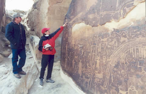
of corner notched projectile points. The most distinctive artifacts of the Fremont Culture in Emery County are elaborate rock
art panels which are located throughout the region. Excellent examples of both petroglyph (etched) and pictographs (drawn or
painted) rock art panels are found in the area. The Fremont people disappeared from the Emery County area about 800 years ago. About that time, Shoshonean peoples,
ancestors of the Ute and Paiute, moved into the area. It is unknown if the Fremont people were absorbed by the Shoshoneans or
if they moved off and joined other peoples, perhaps the Hopi or Pueblo peoples. When the first Anglos entered eastern Utah, the
Ute were the primary inhabitants. Although no particular band claimed the Emery County area as their territory, reports of
early travelers indicated that the Ute were present throughout the region.2 HistoryIt is unclear when the first non-native peoples entered the Emery County region. The expedition of Juan Maria Antonio Rivera
passed near the site of Moab in 1765, but did not trek into the Emery County region. The Dominquez-Escalante expedition also
by-passed Emery County in 1776. Two "mountain men," James Workman and William Spencer, became separated from their party on the
Arkansas River in 1809. They purport to have wandered through eastern Utah until they met up with a Spanish trading caravan
bound for Los Angeles. There are questions about the validity of their story, but if true, they would have been the first Anglos
to journey through the Emery County region. The earliest authenticated account of Anglo penetration into Emery County was Jedediah Smith's expedition of 1826. In the
1830s, Emery County became part of the Spanish Trail, which extended from Santa Fe to Los Angeles. Between 1830 and 1860,
numerous expeditions passed through or near Emery County, including expeditions led by Kit Carson (1848), E. F. Beale (1853),
John W. Gunnison (1853), and John C. Fr��mont (1853-54). In the 1860s, increased Mormon settlement in the Sanpete Valley west
of the Wasatch, led to increased exploration of the Wasatch Plateau and likely the Emery County region. In 1865, a conflict
between settlers at Manti and the Ute, known as the Black Hawk War, broke out. In mid-1865, two forces of Mormon militia were
sent into the Emery County region in pursuit of Ute raiders who had stolen livestock from Mormon settlements in the Sanpete
Valley. Although the raiders escaped with their bounty, the militia expedition helped expose the Emery County region to
residents of the Sanpete Valley, many of whom would spearhead settlement of Emery County in the following decades.
3 In the mid-1870s, stockmen began moving their herds into the Emery County region. Drawn by the wide-open territory, they
sought to relocate their herds away from the crowded ranges to the north and west, and Emery County was the perfect location
for them to expand their operations. Many who cared for the herds would become Emery County first permanent Anglo residents. In late August of 1877, Brigham Young, president of the Church of Later Day Saints (LDS), issued an order to the Sanpete LDS
Stake president seeking ". . . at least fifty families [to] locate in Castle Valley this fall." The order led to the founding
last Mormon colony settled under the direction of Brigham Young. One week later on August 29, Young, the Great Colonizer, died.
During his 30 years as leader of the LDS Church, Young had overseen and directed the establishment of almost 400 towns and
villages. The settlement of Emery County was his last.4 Soon after issuance of Young's order, several bands of settlers moved out from the Sanpete region headed for Castle Valley
(Emery County). They settled along Huntington Creek, Cottonwood Creek, and Ferron Creek. The following spring (1878) several
more families moved into the region. In the spring of 1878, Elias Cox and Charles Hollingshead set up a saw mill in Huntington
Canyon to provide lumber for the colony. On Ferron Creek, setters plowed lands and began construction of a ditch for irrigation.
Most of the early settlers in Castle Valley claimed easily watered bottom lands along the creeks and rivers, and by 1879, most
of the best lands had been taken up. Plans were drawn up to construct ditches to carry water to lands further from the streams
and rivers. Ditch construction usually took place during the winter, and within a few years, numerous ditches were carrying to
lands throughout the region. Emery County was created by the Utah Territorial Legislature in February 1880 and included what later became Carbon County.
The census of 1880 showed 556 people and 84 farms in Emery County, but this figure is likely short as many prominent settlers
were inadvertently left off the county roles. By 1890, the population of Emery County had risen to 2,866, and towns had grown
from groups of ramshackle cabins to communities with schools, stores, and churches. Early ditches which tended to be small and
served limited area were consolidated into large canals serving much greater acreage. Between 1880 and 1900, many significant
canals were constructed, including the Huntington Canal (1884), Emery Canal (1885), Cleveland Canal (1885), and the Wakefield
Ditch (1880). Many of the early canals are still in service.5 In the early 1880s, the Denver and Rio Grande Western Railroad began investigating rail routes through the Emery County
region. Early plans to locate the railroad through the heart of Emery County were thwarted when the route over the Wasatch
Mountains proved to be too steep. The alternative route took the rails through the north-eastern corner of the county,
by-passing most of the settlements in the county. While most of the county did not immediately benefit from the railroad, Green
River, on the eastern edge of Emery County boomed almost overnight following arrival of the rails. By 1900, the population of Emery County had reached over 4,600 people. Over 450 farms were operating in the county, growing
crops on over 25,00 acres. Irrigation systems were being expanded to bring new lands into production, bringing with them
problems which would plague the region for several decades. Water rights conflicts frequently arose, and water theft, known as
"midnight irrigation," became common. Most disputes were settled by decree, but a few were contested by violence. During the
early 1900s, the residents of Emery County began to experience a problem that was common among irrigators throughout the west:
insufficient late season flows. To combat this problem, small storage reservoirs were constructed, providing limited relief. In
1902, a local irrigation convention drafted a petition seeking government assistance under the newly enacted Reclamation Act,
beginning a decades-long quest for a federal reclamation project.6 By 1920, the amount of irrigated acreage had increased to over 43,000 acres, but much of the increase was offset by the loss
of land through degradation. The underlying soils in Emery County consist of ancient seabeds which contain high levels of salts.
Poor drainage and over-irrigation causes the salts to collect on the surface, rendering large areas of land unsuitable for
agriculture. The problem first appeared in the 1890s, and in 1903, a Department of Agriculture report stated that over 30% of
the developed farmland in Emery County had been abandoned due to degradation. Experimental drainage projects were developed
which showed some promise, but the cost proved too high for widespread implementation. To overcome the loss of lands, new lands
were brought into production by expanding existing systems and developing new ones. With expanded irrigation development came expanded settlement has several new towns were established. In addition, the coal
industry, which had consisted of a few small mines which provided for local demand, expanded and several large scale operations
began. The entry of the United States into World War I created a minor boom in Emery County as agricultural prices rose and
manpower shortages caused wages at the mines to rise. Following the war, prices dropped significantly, leading to hard times
throughout much of the 1920s. Things improved somewhat during the later years of the decade, but an even more significant
collapse came with the onset of the Great Depression in the early 1930s. In addition, severe drought in 1931 and 1934
intensified the economic hardship in the county. The decade of the 1930s was difficult for the residents of Emery County. The population of the county dropped from over
7,400 in 1920 to a little over 7,000 in 1930, and remained steady through the 1930s. Agricultural prices dropped 40% from their
1929 level, and coal production dropped by half. Water shortages and land degradation continued to be a problems has yet there
had been no solution to the long term storage problem. In 1935, only 16,462 acres out of 41,725 acres produced crops.
7 The residents of Emery County benefited from many depression-relief programs, including the Civilian Conservation
Corps (CCC). Several CCC camps were established in Emery County. Company 959 established a camp in Joes Valley in May 1933. The
camp moved several times in the following years before establishing a permanent camp near Ferron in 1935. A second camp was
established at Castle Dale in 1935, and another camp was established at Green River in 1938. During its tenure in Emery
County, the CCC built road, bridges and trails as well as building ranger stations and other projects on public lands. Many
enrollees settled in Emery County after their discharge from the Corps.8 The drought of the mid-1930 highlighted the need for an augmented water supply. New reservoirs were build and other
enlarged. Several small irrigation and ditch companies merged, pooling their resources to provide better service. The desire
for a stable water supply renewed interest in Joes Valley as a reservoir site. In 1937, the state planning board approved the
idea, and testing at the site was carried out. Local interest promoted the project, seeking federal relief funds for
construction. In 1941, the Bureau of Reclamation supported construction of a reservoir in Joes Valley using funding from the
Works Progress Administration (WPA) and using CCC labor with local water users paying for about half the project. In order for
the project to be feasible, water users from both the Cottonwood Creek and Huntington Creek would have to join together. The
Huntington-Cleveland Irrigation District wanted to build a reservoir at Miller Flat, but Reclamation rejected the idea as not
feasible and urged the Huntington group to support the Joes Valley plan. Cottonwood Creek water users unanimously supported the
Reclamation plan which would have given almost three-quarters of the project's water to the Huntington Creek water users, but
the Huntington Creek contingent withheld their support, electing to pursue the Miller Flat Reservoir them selves. Without the
support of the Huntington Creek water users, the Joes Valley project was reduced to a low priority project. All projects in the
region were put on hold by the outbreak of World War II in 1941.9 Following the end of World War II, service men from Emery County returned home to find relative economic prosperity. County
farm income in 1946 was double that of 1940, and the coal mines were operating at fairly high levels. During the post-war
years, the county matured and modernized as modern water and sanitation systems were constructed, roads were improved, and many
of the luxuries enjoyed by people in less rural areas, like telephones, reached Emery County. While many things in Emery County
improved, some things did not. The agricultural sector still suffered from inconsistent water supplies and a lack of
significant long term storage. And in the mid-1950s, the region again suffered from a period of low precipitation. It was also
during this time that the long sought after reservoir in Joes Valley would become a reality. In 1956, the Bureau of Reclamation
receive approval to construct the Colorado River Storage Project which included development of Joes Valley as part of a
participating project.10 PROJECT AUTHORIZATIONThe Emery County Project was authorized as a participating project of the Colorado River Storage Project by the Colorado
River Storage Project Act of April 11, 1956 (Public Law 84-485), a comprehensive program to develop the water resources of the
Upper Colorado River Basin. Under the Act, excess revenues from power production at the main Project units, Flaming Gorge,
Curecanti, and Glen Canyon, would be used to help repay the construction cost of the participating projects. Water users on the
participating projects would only be liable for those project costs allocated to irrigation. Other project costs allocated to
flood control and other project functions would be repaid from excess power revenues of the primary project units.
11 Following approval of the Emery County Project, it was necessary for the local water users to form a district to act as the
contracting agency for repayment of the project. The formation of this district, a requirement of Reclamation law, highlighted
several sectional rivalries which had in the past prevented construction of a reservoir in Joes Valley. In addition, there were
concerns over relinquishing water rights to the federal government. But the efforts of the district supporters were boosted by
the fact that Emery County was experiencing a drought, and local water users were acutely aware of the need for large scale
water storage. The Emery Water Conservancy District was formed on April 4, 1961, and a contract for repayment of almost
$3,000,000 of the nearly $8,000,000 project cost was approved by 96% of the voters in May 1962. 12 CONSTRUCTION HISTORYThe first contracts let in association with construction of the Emery County Project were let in late 1962. Those contracts
were for construction of a laboratory building, and for construction of streets and a utility system for the Government camp at
Castle Dale. The laboratory was completed in August 1962, and the camp in December. Bids for the construction of Joes Valley Dam were opened on May 2, 1963. The contract was awarded to S.S. Mullen, Inc. of
Seattle on May 10. The winning bid was $3,562,260. The contractor acknowledge the notice to proceed on June 21, 1963, setting a
completion a date of June 25, 1966. Actual construction began on June 20 with excavations for the access road and preparations
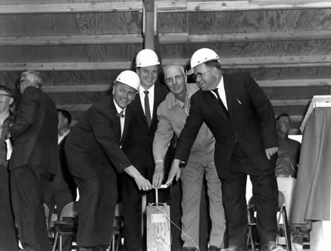
for excavation of the diversion tunnel.13 Ground breaking for Joes Valley Dam was held on June 20, 1963. Those in attendance included Utah Governor George Clyde, Utah
Senator Frank Moss, Reclamation Commissioner Floyd Dominy, and Reclamation's Chief Engineer Barney Bellport. During the ground
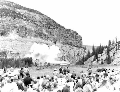
breaking ceremony, the dynamite blast which was to commemorate the beginning of construction went off prematurely, prompting a
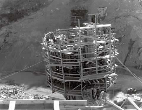
rather frightened outburst from the Commissioner.14 Work on Joes Valley Dam progressed throughout the summer of 1963. Concrete operations began in mid-September with placements
in the outlet works conduit. The diversion tunnel, which would be incorporated into the spillway system, was holed through on
October 7, and by the end of 1963, foundation excavations were 70% complete while concrete placements in the outlet works was
almost 60% complete. Concrete placements in the diversion/spillway tunnel were about 13% complete and the spillway chute was
over 60% complete. Bids for construction of the lower reach of the Cottonwood Creek-Huntington Canal were opened in late November 1963. The
contract was awarded to R.A. Heintz Construction Company of Portland, with a winning bid of $1,578,851. Notice to proceed was
given on December 21, 1963, although actual construction under the contract began on December 12.
15 Construction activities increased significantly in 1964 with the start of work on the Cottonwood Creek-Huntington Canal and
the advancement of work at Joes Valley Dam. The Contract for construction of Swasey Diversion Dam and the upper reach of the
Cottonwood Creek-Huntington Canal was let April 30. The contract was awarded to R.A. Heintz which had submitted the winning bid
of $645,610. Notice to proceed was given on May 6, with work beginning in mid-July. Clearing for the Swasey Diversion Dam began
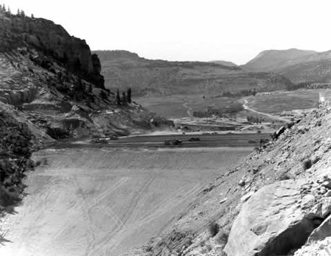
in July, and the creek was diverted around the construction site at the end of the month. At Joes Valley, work continued throughout the summer and into the fall of 1964. Clearing of the reservoir area was completed
in mid-June. Seely Creek was diverted through the diversion tunnel on August 20, and placement of embankment material began in
September. By the end of 1964, embankment operations were advancing steadily, all excavation work was complete, and over 95% of
the concrete work was complete. Work on Swasey Diversion Dam and the upper reach of the Cottonwood Creek-Huntington Canal was
well advanced, and the lower reach of the canal was more than 2/3 complete. The contract for construction of the Huntington North Dam and Dikes was awarded on December 14, 1964. The winning bid of
$741,286 was submitted by W. W. Clyde and Company of Springville, Utah. Notice to proceed was issued December 14, with
construction activities beginning the same day.16 Construction activity picked up significantly in 1965 with the start of construction of the Huntington North Dam and Dikes
in late January. Other activity in association with construction of Huntington North Reservoir included relocation of several
ditches which ran through the reservoir area. The ditch relocation was carried out under a separate contract which was let in
October 1964. The relocations were completed in mid-June 1965. In late April, work on the Swasey Diversion Dam was sufficiently complete to allow diversion of Cottonwood Creek over the
overflow section of the dam. The last major contract to be let in association with construction of the Emery County Project was
let in late June. The contract for construction of the Huntington North Service Canal and Huntington North Feeder Canal, was
awarded to E.V. Chettle in late June. The accepted bid was $274,566. The contractor received the order to proceed in early
August. On May 17, workers for S.S. Mullen began placement of zone 1 materials at Joes Valley Dam. The embankment was competed on
October 22, and on November 3, the diversion tunnel was blocked, allowing storage to begin in Joes Valley Reservoir. By the end
of 1965, Joes Valley Dam was essentially complete with only placement and grouting of the diversion tunnel plug and minor
concrete work remaining. The contracts for construction of Swasey Diversion Dam and both reaches of the Cottonwood
Creek-Huntington Canal were accepted as complete on December 17.17 All major features of the Emery County Project were completed during the first half of 1966. Huntington North Dam and Dikes
were completed on January 6, and filling of the reservoir began in April. Construction of the Huntington North Feeder Canal was
accepted as complete on April 8, and the Huntington North Service Canal on July 23. Joes Valley Dam was accepted by Reclamation
on June 23, and deliveries of project water began on July 1, with deliveries to fields in the Cottonwood Area.
18 Joes Valley Dam is a zoned earthfill dam, 192 feet high, 750 feet long, and containing 1,290,000 cubic yards (cy) of
material. Joes Valley Reservoir a maximum of 62,460 acre-feet (af) and as a surface area of 1,170 acres at capacity. Swasey
Diversion Dam, ten miles downstream from Joes Valley Dam, is a concrete overflow weir with earth embankment wings. It is 11
feet high and 75 feet long and has a diversion capacity of 165 cubic feet per second (cfs). Swasey Diversion Dam diverts
project water into the Cottonwood Creek-Huntington Canal which extends northward for just over 16 miles, ending at the historic
North Ditch. The Cottonwood Creek-Huntington Canal is concrete lined with an initial capacity of 165 cfs. The Huntington North Feeder Canal heads at North Ditch and runs southward about 1/2 mile to the Huntington North Reservoir.
It is concrete lined and has a capacity of 100 cfs. Huntington North Dam and Dikes are of zoned earthfill construction and form the Huntington North Reservoir. The main dam is
74 feet high and 2,897 feet long. The East Dike is 31 feet high and 1,185 feet long, and the West Dike is 24 feet high and
1,919 feet long. The total volume of the main dam and two dikes is 967,000 cy. Huntington North Reservoir has a maximum
capacity of 5,420 af and a surface area of 242 acres. The Huntington North Service Canal heads at the East Dike of the
Huntington North Reservoir and goes generally eastward for about 3 and a half miles, ending at the historic Cleveland Canal. It
is concrete lined and has a capacity of 35 cfs.19 POST CONSTRUCTION HISTORYThe Emery County Project was transferred from construction status to operational status on January 1, 1967. In 1968, just
over 16,500 acres of project land received water. The amount of irrigated acreage reach 17,200 acres in 1970, the same year the
Emery Water Conservancy District assumed operation and maintenance of the project irrigation facilities. In early 1969, the
United State Government and the Utah Division of Parks and Recreation signed an agreement whereby the State of Utah would
develop and administer recreation at the Huntington South Reservoir. Construction of a project drainage system began in November 1971, with work on the open pilot drain. This work was completed
in July 1972. Construction of the first block of drains began in May 1973, and was completed in November. Contracts for
construction of additional drains were let in 1974 and 1976.20 In the late-1960s and early-1970s, Emery County underwent significant economic change. Coal production in Emery County and
the surrounding area had reached a peak in the late-1950s, declining steadily throughout the 1960s. In February 1969, Utah
Power & Light announced plans to construct two large coal-fired powerplants in the area. The Emery County area was a logical
place to locate the plants. With the coal mines nearby, the costs of transporting fuel to the plants would be significantly
reduced. But there was also a need for large amounts of water. In all, the powerplants would require 27,000 af of water for
their operations. Utah Power & Light was able to acquire 15,000 af of primary water right on Huntington Creek, and an
additional 6,000 af from Cottonwood Creek. To obtain the remaining 6,000 af, Utah Power & Light turned to the Cottonwood Creek
Consolidated Irrigation Company, seeking a share of its project water stored in Joes Valley Reservoir. While there was some
concern about the effects of large scale development on Emery County, most recognized the enormous economic benefits that would
be realized by such development. Many farmers agreed to sell a portion of the their water while others tendered all of their
water stock, effectively abandoning their farming operations to help secure the counties economic future. By February 1970,
sufficient water had been secured to enable Utah Power & Light to proceed with construction of the first generating units.
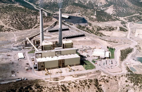
21 Construction of the Utah Power & Light generating plants had an immediate impact on Emery County. Population in the county
grew from just over 5,000 in 1970, to a peak of over 13,000 in 1983. In addition, Emery County went from being one of the
poorest counties in Utah to being one of the richest. The first powerplant, the Huntington Powerplant, located eight miles west
of Huntington, began operating its first unit in 1974. The second unit came on-line in 1977. The second powerplant, the Hunter
Powerplant, located three miles south of Castle Dale, began operations in 1978, when the first of its three units went on-line.
The second unit entered service in 1980, and the third in 1983. Today, the two powerplants employ over 500 people. In addition,
the mines which provide high quality , low sulfur coal to the powerplants employ over 600 people. The development of the power
industry in Emery County and the subsequent revitalization of the coal industry has provided the county with the economic
stability it had long sought.22 In 1974, the Congress passed the Colorado River Basin Salinity Control Act which authorized the construction and operation
of facilities in the Colorado River Basin to help control the salinity level of water delivered to Mexico as required under
Minute 242 of the International Boundary and Water Commission. Title II of the Act provided for the specific construction of
several salinity control units in Colorado, Utah, Arizona, and New Mexico. One of those units was the Price-San Rafael Unit in
Emery and Carbon Counties. Almost 430,000 tons of salts are contributed to the Colorado River system from the Price and San
Rafael River Basins each year. Of that amount, almost 60% is attributed to agriculture in the form of irrigation run-off and
canal seepage. To combat this problem, Reclamation proposed several solutions including improvements to irrigation systems,
capturing agricultural drainage for other uses, disposing of saline water by deep-well injection or in evaporation ponds, and
retiring land from irrigation. Of the proposed solutions, improving irrigation systems proved to be the most viable based on
effectiveness and acceptability. In the mid-1990s, Reclamation began a program of converting historic, un-lined canals to buried pipe to reduce or eliminate
losses due to seepage. This program did not involve piping any canals constructed under the Emery County Project, which are all
concrete-lined, but rather canals built during the early decades of settlement. Because of the historic nature of those canals,
Reclamation, in cooperation with State and local organizations, is developing a program to interpret the historic significance
of those early canals so that present and future generation will know about the important role those canals and their builders
played in the settlement of Emery County.23 SETTLEMENT OF PROJECT LANDSThe authorized purpose of the Emery County Project was to supply supplemental water to over 18,000 acres of mostly
previously developed farm and pasture land. As such, there were no new lands withdrawn for settlement under the project. The
addition of a reliable supply of water for irrigation stabilized the agricultural economy of the region. In the 1970s, the
acreage available for service was reduced by 4,600 acres as 6,000 af of project water was reallocated to help support
development of the power industry. The development of the power industry was a catalyst for growth and development in Emery
County, providing hundreds of construction and support jobs. Following construction of the power facilities, the economic boost
continued as the coal industry stepped up production to provide fuel for the powerplants. Through the reallocation of a
portion of the project's water from agriculture to power generation, the project provided indirect support for the economic
and population growth in the region. In 1995, the population of Emery County was just over 10,400, down slightly from 11,400 in 1980 when construction of the
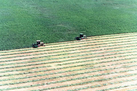
area's power facilities was at its peak.24 PROJECT BENEFITS AND USES OF PROJECT WATERThe primary benefit of the Emery County Project is irrigation. The project provides supplemental water to about 250 full and
part-time farms covering more than 18,000 acres. In 1992, the most recent reporting year, over 15,700 acre of land received
project water. The primary crops grown consist of forage crops such as alfalfa hay and irrigated pasture. The total project
crop value for 1992 was just over $2,200,000. The project also supplies 6,000 acre-feet (af) of water for electric power generation at three powerplants owned and
operated by Utah Power & Light. The availability of project water for power generating purposes was critical to Utah Power &
Light's decision to build its powerplants in the area. The jobs created by the power industry have been a significant boost
to the area's economy. In addition, dozens of jobs were created at area coal mines that supply coal to the powerplants,
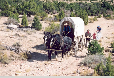
further extending the benefits of the project. Recreation is also an important benefit provided by the project. Recreation areas at Joes Valley Reservoir and Huntington
North Reservoir annually host more than 200,000 visitors each year. Boating, fishing , and camping are the most popular
activities enjoyed at these areas. Recreation at Joes Valley Reservoir is administered by the United States Forest Service,
while activities at Huntington North Reservoir are administered by the Utah Division of Parks and Recreation.
25 CONCLUSIONThe people of Emery County have always faced challenges: build communities in the arid and inhospitable wilderness, provide
for the needs of those communities, and find ways for the communities to grow and prosper. The development of the Emery County
Project helped the people of the region to overcome many challenges and provide a solid base on which the region could grow. As
Emery County moves into the new century, the Emery County Project will continue to contribute to the solid base from which the
people of the county can rise to meet the challenges which confront them. ABOUT THE AUTHORWilliam Joe Simonds was born and raised in Colorado and has a clear understanding of the importance of water in the American
West and its influence on the development of that region. He attended Colorado State University where he received a BA in
History in 1992 and a Masters in Public History in 1995. He lives with his wife and two children in Fort Collins, Colorado. BIBLIOGRAPHYArchival MaterialsNational Archives and Records Administration, Rocky Mountain Region. Record Group 115. Records of the Bureau of Reclamation.
Project Histories, "Emery County Project," Vol. I - XV, 1962 - 1976. Government Documents and PublicationsDepartment of the Interior, Bureau of Reclamation. Summary Statistics, Water, Land, and Related Data, Denver: US
Government Printing Office, [1995]. Department of the Interior, Bureau of Reclamation. Repayment of Reclamation Projects. Washington: U.S. Government Printing Office, 1972. Department of the Interior, Water and Power Resources Service. Project Data. Denver: US Government Printing Office,
1981. BooksGeary, Edward A. A History of Emery County. Utah Centennial County History Series. Salt Lake City: Utah State
Historical Society, 1996. Sturtevant, William C., ed. Handbook of North American Indians. Vol. 11, Great Basin. Washington DC: Smithsonian Institution, 1986. Electronic Resources"Colorado River Basin Salinity Control Program - Overview," Project Dataweb, Bureau of Reclamation.
http://dataweb.usbr.gov/html/crwq.html. September 5, 2000. "CRBSCP - Price-San Rafael Rivers Unit, Utah," Project Dataweb, Bureau of Reclamation.
http://dataweb.usbr.gov/html/price-san.html. September 5, 2000. "Emery County Project Engineering Data," Project Dataweb, Bureau of Reclamation,
http://dataweb.usbr.gov/html/ucemeengdata.html. June 26, 2000. "Emery Water Conservancy District, Emery Unit General Description,"
http://www.ewcd.org/history/sys_desc/. March 2, 2000. "USA Counties - Emery County, Utah, Summary Report"
http://govinfo.library.orst.edu/cgi-bin/usaco-list?30-015.utc. July 21, 2000. "Utah Power." http://www.utahpower.net. June 1, 2000. Oral History InterviewsJohansen, Oral Eugene, Clyde Conover, and Mack Bunderson, Interview by Wm. Joe Simonds, 13 April 2000, transcript,
Bureau of Reclamation Oral History Program, Denver, Colorado. Journals and Magazines"Major Recent Contract Awards." Reclamation Era, February 1964, 24. "Major Recent Contract Awards," Reclamation Era, February 1965, 32. "Major Recent Contract Awards," Reclamation Era, November 1965, 116. FOOTNOTES1. Department of the Interior, Water and Power Resources Service, Project Data, (Denver: US Government Printing
Office, 1981), 453-455; "Emery Water Conservancy District, Emery Unit General Description,"
http://www.ewcd.org/sys_desc/, March 2, 2000. 2. William C. Sturtevant, ed. Handbook of North American Indians (Washington DC: Smithsonian Institution, 1986),
vol. 11, Great Basin, 163-172; Edward A. Geary, A History of Emery County, Utah Centennial County History Series,
(Salt Lake City: Utah State Historical Society, 1996), 17-22. 3. A History of Emery County, 24-40. 4. Ibid., 47-59. 5. Ibid., 62-107. 6. Ibid., 107-174, 184-186. 7. Ibid., 260, 274-275, 277-278. 8. Ibid., 282-284. 9. Ibid., 297-299. 10. Ibid., 315, 317-345, 348-351. 11. Department of the Interior, Bureau of Reclamation, Repayment of Reclamation Projects,
(Washington: U.S. Government Printing Office, 1972), 109. 12. A History of Emery County, 348-349. 13. National Archives and Records Administration, Rocky Mountain Region, Record Group 115, Records of the Bureau of
Reclamation. Project Histories, "Emery County Project," Vol. I, 1962, 7; Vol. II, 1963, 4.(hereafter cited as Project
Histories, "Emery County Project," followed by volume number, year, and page number(s).) 14. Oral Eugene Johansen, Clyde Conover, and Mack Bunderson, Interview by Wm. Joe Simonds, 13 April 2000, transcript,
Bureau of Reclamation Oral History Program, Denver, Colorado (hereafter cited as "Johansen, et al"); Project Histories "Emery
County Project," Vol. II, 1963, 1. 15. Project Histories "Emery County Project,"Vol. II, 1963, 4-5; "Major Recent Contract Awards," Reclamation Era,
February 1964, 24. 16. Project Histories "Emery County Project," Vol. III, 1964, 4-5, 38, 40-41, 43, 51; "Major Recent Contract Awards,"
Reclamation Era, February 1965, 32. 17. Project Histories "Emery County Project," Vol. IV, 1965, 5-8, 29, 38, 41, 48, 62, 67, 71-71; "Major Recent Contract
Awards," Reclamation Era, November 1964, 116. 18. Project Histories, Emery County Project, Vol. V, 1966, 1, 3-5. 19. Project Data, 456, 459; "Emery County Project Engineering Data," Project Dataweb, Bureau of Reclamation,
http://dataweb.usbr.gov/html/ucemeengdata.html, June 26, 2000. 20. Project Data, 455; Project Histories "Emery County Project," Vol. XV, 1976, 56-58. 21. A History of Emery County, 327-329, 359-360. 22. Ibid., 366-372; "Utah Power," http://www.utahpower.net, June 1, 2000. 23. A History of Emery County, 416-417; "Colorado River Basin Salinity Control Program - Overview,"
Project Dataweb, Bureau of Reclamation,http://dataweb.usbr.gov/html/crwq.html, September 5, 2000; "CRBSCP - Price-San
Rafael Rivers Unit, Utah," Project Dataweb, Bureau of Reclamation,http://dataweb.usbr.gov/html/price-san.html, September 5,
2000. 24. "USA Counties - Emery County, Utah, Summary Report" http://govinfo.library.orst.edu/cgi-bin/usaco-list?30-015.utc.
July 21, 2000; Project Data, 453, 455. 25. "Utah Power,"; Johansen, et al; Department of the Interior, Bureau of Reclamation, Summary Statistics, Water, Land,
and Related Data, (Denver: US Government Printing Office, [1995]). |
|
|