The Dark Side of a Promotion: A History of the Elberta ProjectThe Dark Side of a Promotion: A History of the Elberta Project
During its last big fruit harvest, Elberta was alive with activity. Its peach crop had
developed a well-deserved reputation, and the demand for its produce had increased. There was a
rush of activity in the packing houses. Over thirty boxcars of fruit, produce from the area's
thousands of trees, were being shipped out daily on the trunk line of the Denver and Rio Grande
Western railroad. The local economy was booming, and it looked as though the development might
finally succeed. This brief boom period was dashed when a freeze in 1925 destroyed the project's
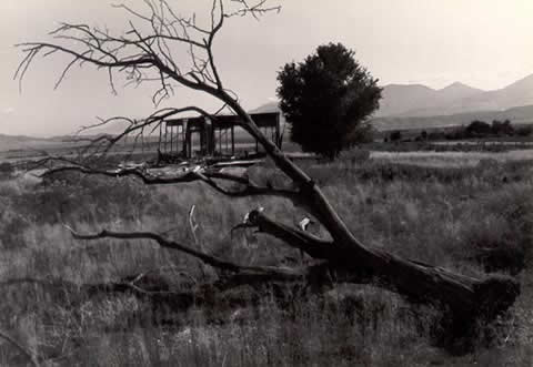
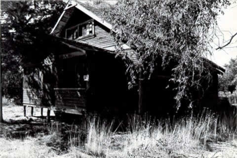
peach trees. Today, Elberta is a few buildings at the intersection of two state highways. The center of
town has moved from the railroad tracks south to an east-west highway which connects Santaquin
and Eureka. In 1984, the town's post office and solitary store were only open a few hours each day. Many
of the community's old homes stood vacant, and the old townsite, had been reclaimed by sagebrush
and cheatgrass. The few dead fruit trees which still dot red the landscape gave the old townsite a
ghost town aura (see Photographs 1 and 2). So, what happened to the once prosperous project? In point of fact, the Elberta project has had a roller-coaster history with incredible peaks
and valleys. Unfortunately for all, the valleys inflicted pain on both the investor-farmers and
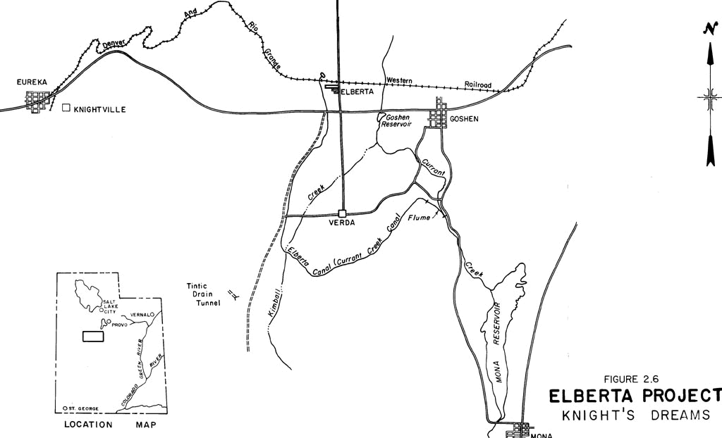
owner-developers. The OriginThe development of the Elberta area, located near the southern tip of Utah Lake, was the
brainchild of two land speculators. In the late nineteenth century, land development in Utah was
relegated to those areas where earlier pioneers had found it difficult to settle. These areas
were far enough from the mountains to make water difficult to obtain and this made irrigation
farming an expensive proposition. The Elberta lands in southern Goshen Valley were such an area. Gilbert S. Peyton, a gentleman who had made money in Mercur, Utah, from the discovery of a
cyanide milling process for gold, and his lawyer associate, E. G. Rognon, decided to use a
portion of their wealth and go into the dam building and irrigation business ( Penrod, undated; Steele, 1960). They purchased 10,000 acres of barren state
and federal land in southern Goshen Valley with the intent of placing it under irrigation.
Peyton and Rognon were familiar with the successful orchards around Grand Junction, Colorado.
The two speculators figured that if peaches were successful in Grand Junction, why not in
Goshen Valley? The water rights and land for their proposed reservoir were purchased from William Starr, a
Juab Valley rancher. Rognon and Peyton became the owners of the Starr Irrigation Company. The
company was eventually incorporated as the Mt. Nebo Land and Irrigation Company. Peyton and
Rognon were the principals along with H. W. Brown. In 1895, Rognon entered into an agreement
with the Goshen Irrigation and Canal Company, the principal irrigators on Currant Creek. Rognon
agreed to furnish a stipulated quantity of water each year to the Goshen company, in return for
which the company agreed to transfer its water right to him. An ideal damsite was located in a narrow constriction of the channel at the head of Goshen
Canyon. Construction on a small earthen dam (using wooden plows, scrapers, and a tamper) was
begun soon after the purchase of the reservoir site. A crude spillway was hewn out of the
agglomerate on the dam's northern abutment. All went smoothly until typhoid fever broke out.
Currant Creek had been tested for cleanliness, but unfortunately the tests were taken upstream
and the men were drawing their drinking water from below their camp and construction site. The
water became contaminated and many of the men caught typhoid fever; one man died and several
more were never able to return to work (Steele, 1960).
Despite this setback, the small dam was eventually completed (see Photograph 3). To get the irrigation water to the company's benchland, the Mt. Nebo Land and Irrigation
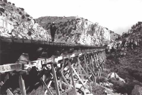
Company had to divert its water well up Goshen Canyon. To get the water down the canyon, it
was necessary to build a long impressive flume. The flume, constructed of redwood staves, was
six feet wide and ran about one and one-half miles down the canyon, some sections resting high
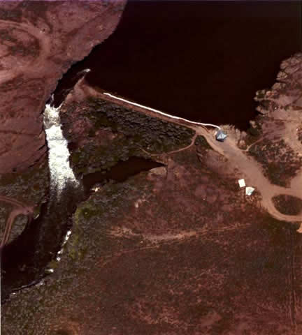
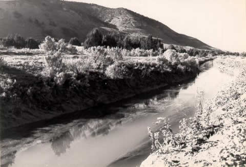
on a wooden trestle, others just clinging to the sheer rock cliffs. (see Photograph 4). At the mouth of Goshen Canyon, the flume emptied into an unlined canal which circled around
the southern end of Goshen Valley before ending at a terminal reservoir just north of the
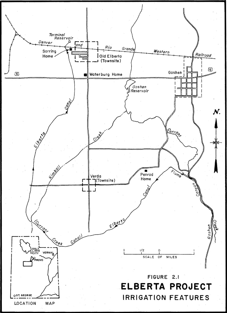
present-day community of Elberta (see Photograph 5). The lands to be serviced by the canal system were located
inside a natural amphitheater created by the nearby mountains, which overlook the southern end of the
valley (see Drawing 1). Once placed under production, the lands to be serviced by the Elberta project had an
excellent capacity for crop production. All that was required was a reliable water supply. At the north end of the project, the town of Mt. Nebo (named after the mountain which
dominated the southeastern horizon) was laid out. It was to be built around the Denver and Rio
Grande Western Railroad tracks which served as a vital support for the new project. The
railroad provided access for potential investors as well as transport to get the "fruits" of
the project to market. It was near the railroad that the first buildings in Mt. Nebo rose,
a commissary, consisting of a store, warehouse, boarding house, and hotel,
and a group of tents to serve as general purpose shelters. 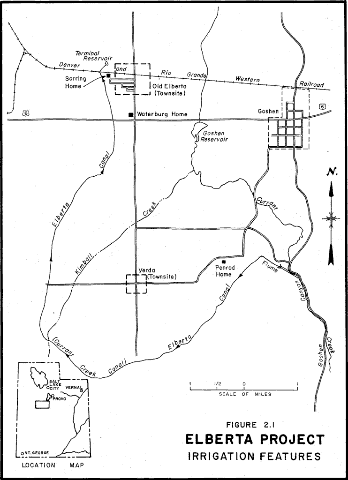
Drawing 1. Elberta Project Irrigation Features.
 | Click on the image for a larger version. |
Before the reservoir and flume were completed, additional monies had to be raised to finance
the expensive project. To accomplish this, H. W. Brown went to Nebraska, Kansas, Illinois and
Iowa to sell land in the project. According to Raymond Steele, historian of Goshen valley,
Brown told potential investors: by pamphlet, pictures, and personal contacts the
wonderful opportunities Mt. Nebo offered to those that
wanted to better their condition--a land of opportunity
for the fruit grower--a locale where apples, peaches,
pears, and other small fruit could be raised with very
little work.
Grain prices in the Midwest were depressed, so the promises made by the Elberta promoter
fell on receptive ears. According to Doris Penrod in her history of Elberta, many of the settlers who came to Goshen
Valley felt they had been cheated. She states that prospective buyers were shown pictures of a
thriving metropolis, and when they got off the train at Mt. Nebo and saw nothing but sagebrush
and tents they were mad as hell. Some just waited till the train came back and reboarded;
others stayed only because they had no money for a train ticket back or because they had "the
pioneer spirit and decided to make the best of it." In all, about 25 families moved to the Mt.
Nebo project from the East and Midwest. Not all of the initial reactions were negative. The Miller family represents a more positive
story. Henry Miller, before buying property, made a trip out West to inspect the land. He found
it fertile and purchased land near the canal for fifty dollars an acre, including water. He
moved his whole family out in two emigrant railroad cars, paying $135 for each car. Whatever the settler's initial reaction, things went well enough to ship in thousands of
fruit trees from Colorado and Utah nurseries. The first trees were planted in neat rows in
orchard fashion. Since water had not yet reached the end of the canal system, it had to be
hauled in barrels from a nearby reservoir. Shortly after the water was first diverted into the project's irrigation system, the canal
broke, and service was disrupted for two weeks. Meanwhile the settlers were again forced to
haul water and pour it bucketful by bucketful on the newly planted trees. The conveyance system
turned out to be very expensive to maintain. This put the already financially strapped Mount
Nebo Land and Irrigation Company in further jeopardy. Additional problems developed when the
project's water right was found to be inadequate. As with other irrigation projects in the West, the area served by the project was too large
for the water supply. The landowners and the Mt. Nebo company had frequent disagreements over
the delivery of water and the payment for its use. One source for these disagreements can be
seen in the project's water deeds registered in Juab County. For example, Neils Anderson Sorring
purchased a water right (for 40 acres of land) from the company. The "quantity of water
represented by said right being 1,742,400 cubic feet." For farmers from the Midwest, this may
have seemed like an adequate supply. Unfortunately, this amounted to only one cubic foot of
water for each square foot of land, and agricultural engineering studies have indicated that
land in the Elberta area requires at least three times that amount of water to sustain
reasonable growth. In addition to internal difficulties with water deliveries, disagreements arose between the
Goshen Irrigation and Canal Company, independent water users, and the Mt. Nebo Land and
Irrigation Company on the division of water. A court action was initiated to adjudicate the
rights of all water users of Current Creek. In 1902, a decree was handed down which gave to the
prior water users a definite amount of water and decreed the balance to the Mt. Nebo Land and
Irrigation Company. In essence, the Mt. Nebo company received what was left over after the
demands of the prior appropriators were met. During wet weather the project could fill its
reservoir, but during dry years they had last call on a comparatively small creek. At the turn of the century investors, aggravated by an unreliable water supply, were unable
or unwilling to make their payments to the irrigation company. The Mt. Nebo Land and Irrigation
Company, depending on the land income to pay what it owed to Starr, ceased making its payments.
Starr, when the company stopped paying, shut the water out of the canal and placed a 24-hour
guard at the reservoir. Without water for their crops, the settlers on the project began to
drift away and it appeared that the brief boom had run its course. This was a particularly trying period for the new settlers. Folktales relate dismal stories
of individuals driven to despair by the demise of the project. Doris Penrod (undated, p. 9) relates the story of John Jose: He sat day after day watching his farm crops burn up,
and refused to leave, thinking something would turn up.
His wife gave up and refused to stay any longer, and
finally took their family and went back east where they
had come from. He stayed on alone for a while, because
he had invested all he owned in this place, and finally
he committed suicide by hanging himself.
Penrod relates another tragic story of a man named "Mr. Shyster," who after his son died,
just wandered off leaving remaining belongings to whoever wanted them. By 1905, the canal system and other assets of the company were held in receivership by the
Commercial National Bank of Salt Lake City. The bank had received the land from H. W. Brown who
had purchased it in a last effort to save the project. For the next two years there was little
water drawn from the reservoir, allowing it to fill to capacity. With a full reservoir, it was
an opportune time to sell the project. The RebirthThe project was eventually purchased by Matthew B. Whitney, a native New Yorker who had been
in Utah for several years. Whitney had started in New York as a traveling salesman and
eventually ended up in Salt Lake City as a commissioned salesman for an implement company. As a
result of this job he earned enough so that when he heard of the Mt. Nebo project, he
investigated and purchased it in 1907. Whitney and four other men incorporated as the Utah Lake
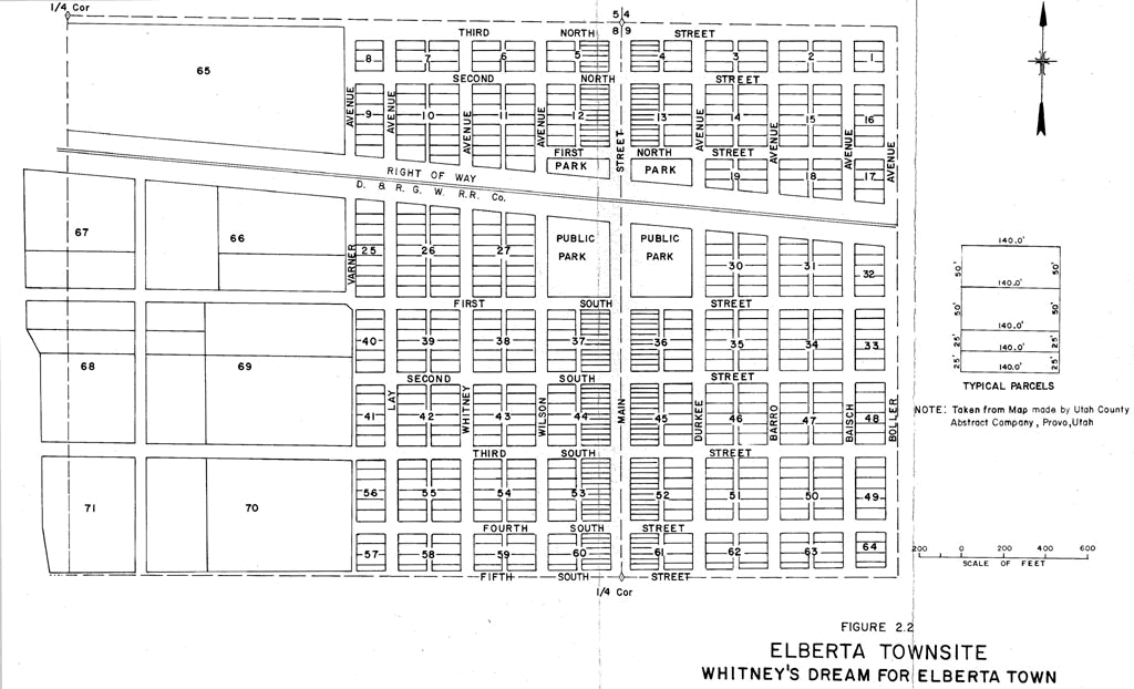
Land, Water and Power Company with capital stock of $935,000. Whitney planned on making the project a major fruit producing area featuring the Elberta
peach. For this reason, he changed the name of the project's town from Mt. Nebo to Elberta.
Whitney's plans were big; he laid out a town complete with a main street, a park, and residential
streets (see Drawing 2). The main street, Cherry Avenue, ran north and south. Along this
street the lots were 50 feet deep with a 25-foot frontage, and were designed to accommodate
businesses. Running parallel to Cherry Avenue were other streets, most of which bore the names
of the stockholders. The lots along these streets were 50 by 150 feet and were intended to be
residential lots. 
Drawing 2. Whitney's dream for the town of Elberta.
| Click on the image for a larger version. |
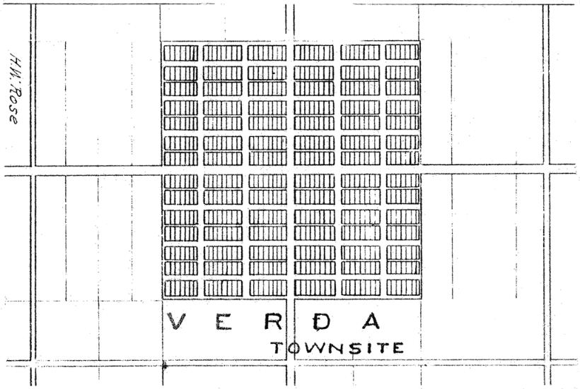
Whitney and his associates also had plans for the southern end of the project. They
established a town at Verda, at a site approximately 2 miles south of Elberta. An elaborate
complex of streets and lots was envisioned for this town as can be seen on an old landownership
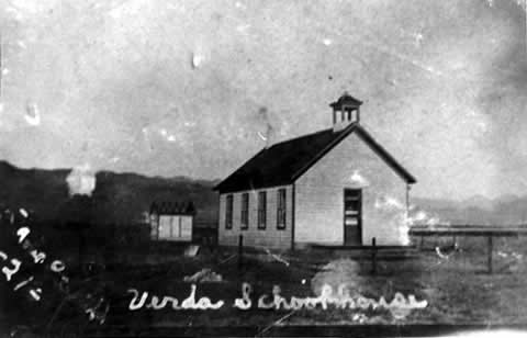
maps (see Drawing 3). Enough people moved into the southern end of the project to require
a school (see Photograph 6). Verda became the center for Mormon settlers and Elberta was viewed as a "gentile" or
non-Mormon community. 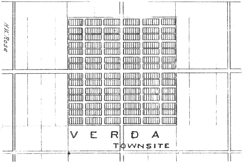
Drawing 3. An ownership map of the Elberta project shows the elaborate plans which were envisioned for the Verda townsite.
| Click on the image for a larger version. |
Whitney had other grandiose plans for his company. The incorporators not only planned to
irrigate the 10,000 acres they had purchased, but were also planning on "constructing, erecting,
owning, leasing, and operating steam or water power, light, and heat for all purposes whatever."
Evidently the plan was for a power plant to be built below the dam to produce electricity. They
were serious enough about the power project to make an agreement with the Mosida boomers to
provide electricity for their pumps. Unfortunately as with other aspects of the project, they
were overly optimistic, and the power plant was never built. The board of directors of the Utah Lake Land, Water and Power Company decided to dispose of
all lands owned by the company (see Drawing 4). W.E.Tollestrup was hired to sell the real estate. Like Brown
before him, Tollestrup decided that the Midwest was a good location for recruiting would be
settlers. 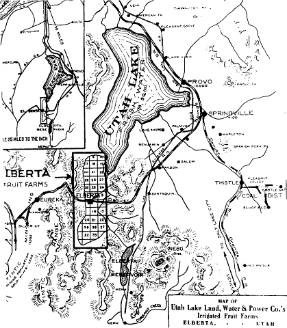
Drawing 4. Map from a promotional brochure showing an exaggerated version of the project's potential service area. Elberta Reservoir could scarcely irrigate a fraction of the lands delineated.
| Click on the image for a larger version. |
Some of the older residents in Goshen Valley tell interesting stories about this round of
promotions. Lloyd Penrod told of the Foote family from Nebraska who came West after seeing a
large poster at a railroad station. The poster described Elberta as the only city in Utah
without "Mormons." Mabel Peterson Finch's parents moved to Elberta from McCook, Nebraska, when
she was a young girl. Her father, Ira Peterson, had a ranch and had served as sheriff for the
four years before he left. The family moved to Elberta in 1910 as the result of listening to
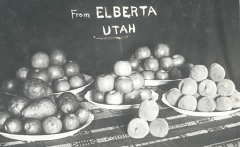
salesmen. Ira Peterson carefully investigated the promoters claims. He came to Elberta twice
before moving his family to Utah. When he first came out in the Spring, the promoters talked so
much about the great harvests in Elberta that he decided to come back in the Fall. After his
second visit, he was evidently impressed by what he saw; he decided to buy a barren 40 acre plot.
Promoters from the company gave him peaches, potatoes, and other fruits to take back with him to
McCook. He also brought home postcards with photographs of peaches, pears, and apples (
see photographs 7 and 8). In spite of Ira Peterson's thorough examination of the Elberta project, there were still
disappointments. When he and his family arrived in April, 1910, they were supposed to have had
a four room house, instead they had to live in the company house until a "shack" was built.
According to Mrs. Finch, "that's all it ever was, we all called it 'the shack."' Besides the lack of housing, other qualities had been exaggerated. Mrs. Finch remembered one
of her mother's anecdotes. While getting ready to leave McCook, her mother was packing her
clothespins, the items to be taken. One of the promoters who was at the house and told her to
leave the clothespins, adding that she wouldn't need them in Elberta. "In Elberta," he told
them "the wind don't blow hard enough to use clothespins." Being a bit skeptical, he mother
said she would take them anyway. It is little wonder Whitney and his company were mistrusted by some of the investors; the
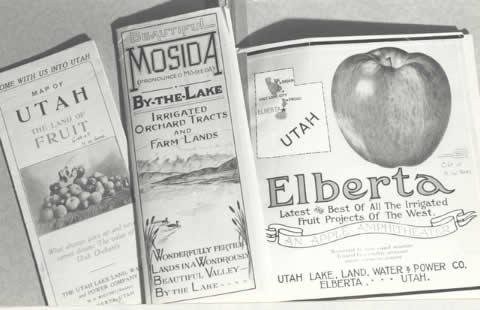
pamphlets they printed painted an unrealistic picture of Elberta. One of the pamphlets states
that, "It is not uncommon for a single apple tree to yield a larger income per year than the
choicest acre of farm land in Iowa or Illinois!" The brochure also promised a bounteous harvest
and excellent financial returns: How must the farmer of Indiana, Illinois, Ohio, Iowa,
Minnesota, Nebraska, Kansas, or Missouri--glad of a $25
per acre profit--view a statement of profits over $250
per acre? Profits sure as death and taxes--returns ten
times as large, from labor one-tenth as great. Yet it
is done--every season--in Utah.
And the cruelest exaggeration of all: "the reservoir is filled--the canals are dug. The
water is ready to be turned in upon every acre sold." Whitney's training as a salesman seemed
to have flowed naturally over into the "hype" which filled his company's brochures. As with the original Mt. Nebo development, water shortages eventually came to haunt the
project. The settlers had been promised water "as long as Mt. Nebo shall stand." But in 1912,
the reservoir ran dry and the irrigators were understandable mad. With water shortage problems, Whitney decided to promote conservation thinking that this
would ease the problem and appease the farmers. Whitney wrote to John A. Widtsoe, president of
Utah Agricultural College, requesting six copies of a poster promoting conservation. The
company appointed a watermaster, and a circular was sent out which outlined the new
conservation program. One thing that Whitney's actions highlighted was the previous lack of organization in making
water deliveries. As long as water had been plentiful, there was no need to conserve, but once
things tightened, a system to better manage water deliveries had to be organized. These
institutions, which had already been developed in the neighboring "Mormon" canals, were
apparently late in in arriving in Elberta. A list of ten rules requiring conservation was developed. Rule nine stated that "all water
for domestic purposes shall be conserved in cisterns of proper size for several months supply.
Arrangements for filling the cistern to be made with the watermaster." These cisterns were not
just the result of the 1912 water shortage, they were an important necessity. There was not a
separate culinary water system in Elberta until 1926. Prior to that year all drinking water had
to hauled in or diverted from the irrigation system. The irrigation water was typically filtered
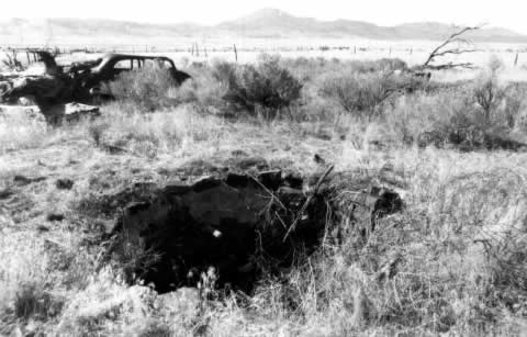
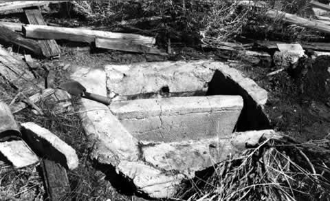
before it was stored in a cistern. During field investigations in 1984, Bureau of Reclamation
personnel located several of the old cisterns and one filter box (see Photographs 9
and 10). The filter was a small
concrete box with two chambers. One chamber was filled with sand and the other with charcoal.
The irrigation water was diverted through the filter to remove suspended solids and other
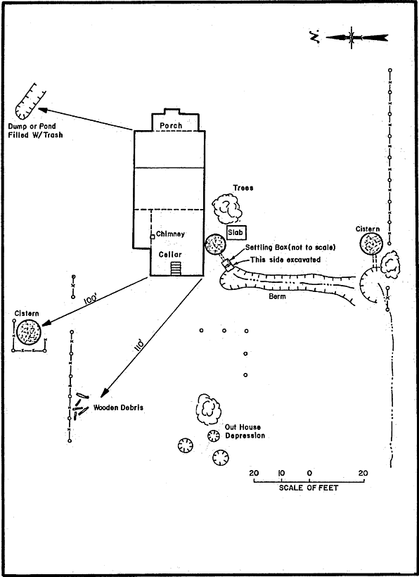
noxious substances. Two of the cisterns located on the Sorring property were approximately 8 feet in diameter,
10 feet deep, and had a capacity of approximately 3800 gallons (see Drawing 5). If the irrigation system was
turned off during the winter months, the storage in one cistern would give a family 40 gallons
of culinary water per day. The cisterns were placed close to the house, and various methods were used to raise the
water. If the need for a cistern was designed into the house, the cistern was placed under the
kitchen or back porch, and a hand pump was used to raise the water. If the house was less modern,
the cistern was located at some distance from the house, and a bucket was used to raise the
water. The cisterns were filled in the fall and were supposed to last through the entire winter.
It was not unusual for the cistern to run dry; when this occurred culinary water had to be
hauled from Goshen in wooden barrels. Culinary water always had to be conserved, and was often
in short supply. Despite the somewhat primitive nature of the Elberta culinary water system,
there is no evidence that there was a significant outbreak of disease. 
Drawing 5. The above drawing shows the spatial relationships on the Anderson Sorring property in Elberta. The two cisterns were fed from the irrigation ditch. During the winter months when there was no water in the irrigation system, the entire culinary water supply was stored in cisterns.
| Click on the image for a larger version. |
Water was not the only thing in short supply. The lack of capital was a problem with both
Whitney and the new settlers. Farm land was sold for $250 per acre with a down payment of $100.
The remainder was to be paid back over a five year period. Many could not afford the down
payment, so they borrowed for it. The new settlers were, in most cases, financially obligated
over their heads. Their farms could not possibly return enough for them to meet their financial
commitments and still have enough left over to live. Whitney depended on the land sales and
annual payments from the homesteaders to keep his company afloat. With the unreliability of the
water supply, it became impossible for for the settlers to make payments for the land and water. With the severe conditions in the repayment schedule, as well as the water shortage, it is
little wonder that the Utah Lake Land, Water and Power Company found itself in financial trouble.
Eventually, Whitney was forced to attempt to try to sell his sinking company. In 1916, he wrote
a letter to Mr. J. F. Jack in Los Angeles, California, trying to convince him to purchase the
project. The asking price for the Elberta project was $1,525,000. Whitney stated that: by spending $6,000 on our canal (it) can be extended,
watering about 1600 acres of our land, which would sell
for $200,000. After all of the above land has been
sold, the company can put in a power plant in our
canyon and pumping plant on our canal and irrigate
3,500 acres more of land we own at a cost not exceeding
$20,000, and said land will sell for $150 per acre,
making $525,000."
Whitney made it sound like a good deal; what he was forgetting to mention was that the
project did not have enough water to irrigate existing developed land let alone additional
acreage. Jack evidently was not interested, for Whitney started negotiations for the sale of the
property to Otho S. Houston and M.B. Loy of Los Angeles in February, 1916. This was the last
promotion Whitney or the Utah Lake Land, Water and Power Co. made. Whitney sold them the company, but when the buyers discovered what a bad condition the
company was in, they sued alleging that the Utah Lake Land, Water and Power Company was not a
legal corporation because of its failure to pay a required state corporate fee. Whitney had
told them the company property was worth $1,301,625.00; Loy and Houston estimated that, without
water and with the flume and canal system in need of repair, the maximum worth of the company
was only $75,000. Houston and Loy won the suit and the project went partially for tax sales,
and partially to a receiver, Edward T. Jones. Mrs. Penrod, in her history of Elberta, states
that: The lawsuits broke the man (Whitney) financially as
well as physically, ...although Mr. Whitney remained
the head of the project, and never ceased trying to
redeem it until his death in the fall of 1917.
The Ultimate DreamLouis Thompson bought the project out of receivership in 1919 and initiated a new era for
the Elberta project. Prior to Thompson, Whitney had sworn that the company would never fall
into the hands of Mormons. However, with the purchase by Thompson, the project became the
property of Mormon investors. Thompson eventually sold the property to a company owned by Jesse Knight, a man important in
Mormon history. The name of Knight's new company was Utah Valley Land and Water Company. Jesse
Knight was not only a Mormon, but a rich one; in less than three years he had gone literally
from rags to riches. Jesse Knight made his money from mining in the Tintic Mountains, located west of Elberta. As
the story goes, he was inspired about a spot of ground in the Tintic area and a geologist-friend
told him it was "humbug" and he would never find productive ore at that location. Eleven years
later he borrowed $1,500 at 12% interest and began mining. His second shipment of ore from the
mine, named the "Humbug," returned $11,189.05. Jesse Knight felt that his newly acquired wealth was a sacred trust, given to him to improve
the lot of the Mormon Church and its members. He planned to use his riches to provide employment
for other people. Known to be a kind man, always striving to help others with his riches, he
became known as "Uncle Jesse," and an easy mark to the people in Utah Valley. According to his
daughter Inez: He loved projects that were unusual. ..big and full
of opportunity for others. As soon as his promotions
were placed on a dividend basis, his interest waned and
he desired to sell as a means of financing other
development.
Knight made numerous investments throughout Utah, the Intermountain West, and Canada. Two of
his projects affected the Goshen Valley area. By 1917 Knight's mines were no longer producing heavily. He decided that what was needed was
a long drainage tunnel to launch a new epoch in the mining industry of the famous Tintic
District; to make possible deep mining by unwatering the whole southern region. .." The drain
tunnel was to extend approximately five miles into the mountains under the southern Tintic
District. Its tunnel portal was located southwest of the Elberta canal in southern Goshen valley.
Jesse Knight had implicit faith in his drainage venture, but unfortunately he had more faith
than money. After tunneling into the mountain
one and one-eighth miles, the project was stopped because of a lack of funding. Uncle Jesse,
showing unusual integrity, personally bought back the stock in the drain tunnel company that
he had encouraged others to buy. At the same time Knight was working on his drainage tunnel, Thompson enticed "Uncle Jesse"
to buy the Elberta property. Knight was convinced of its possibilities and bought the project
despite the opposition of his family and his lawyer (Knight,
1940). Big plans were made for the area, but this time, there was a lack of the elaborate promotion
tactics that Elberta had experienced earlier. The immediate problem was getting the project
back on its feet. The flume was in a dilapidated condition, as was the rest of the irrigation
system. The Utah Valley Land and Water Company spent thousands of dollars repairing the flume
and replacing irrigation headgates. Knight brought in W. T. Jolley as watermaster, and his
son-in-law, Lester Mangum, to manage the project. Unfortunately, the Knight empire was no longer in a healthy financial situation. The Knight
mines were no longer profitable, and the drainage tunnel was sapping cash resources. When the
tunnel was not able to be completed, the mine production continued their decline and the capital
for improvements in Elberta evaporated. Jesse Knight died in 1921, and with him a dream of what
Elberta could become. Exactly what Knight's intentions were in Elberta may never be completely known. We know he
had planned to construct a sugar refinery in Elberta (Penrod,
undated). A cash crop was important to payoff the project's debt. But one nagging question
remains. Did he have any intention to connect the waterway from the drain tunnel to the Elberta
irrigation canal (see Drawing 6). There is no specific evidence he did. But one cannot help but wonder whether
he intended to firm up the project's water supply by supplementing it with the drainage water.
One statement by Knight's son (Knight, 1940) adds a little
light to the subject but does not totally clarify the issue: "He had also in mind the use of
the tunnel water to irrigate the gardens of miners working in the various Knight properties." 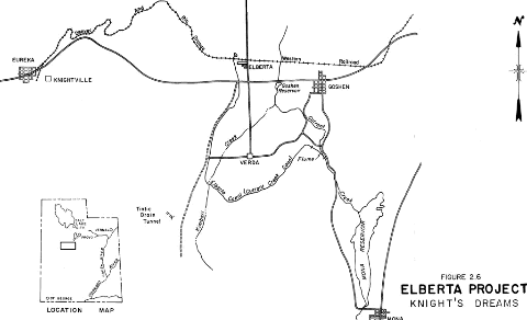
Drawing 6. Knight's Dream for the Elberta Project.
| Click on the image for a larger version. |
In spite of financial difficulties, the Knight empire retained the Elberta project and made
improvements until 1932. To make the improvements, the company mortgaged the irrigation system,
including the water rights, to the Knight Investment Company and the Knight Trust and Savings
Bank. The Utah Valley Land and Water Company tried to irrigate the large acreage that their
predecessors had attempted to irrigate. They also were not successful. The irrigation system
was allowed to deteriorate. The remaining settlers on the project did not receive the water
they had contracted for and refused to make payments on their contracts or for operation and
maintenance charges. The Knight Investment Company and the Knight Trust and Savings Bank
foreclosed their mortgage on the irrigation system and bought the system at a sheriff's sale.
Later the assets of investment and banking companies were acquired by First Security Bank. The
bank was at a loss as to how to operate the Elberta project. In February, 1939, the settlers themselves organized. They formed the Currant Creek
Irrigation Company and acquired the irrigation system including the reservoir, flume, canal,
and water rights. The new irrigation company was run by Pratt Thomas, a banker from Spanish Fork. When Thomas took over, a new system of water delivery was used, a share system. When the
reservoir was full, each share got its full value, but if it was only half full then each share
only received half its value. So at the beginning of the irrigation season each farmer knew how
much water he would receive. This system was much better for planning; if a farmer had an
alfalfa field and water was going to be short, he knew to not plant corn in the next field, but
instead a short season crop. When Thomas switched the system over, a lot of people were bitter.
They felt they were being cheated; they felt the reservoir owners were holding back water for
their own use and "choking them (the farmers) off." After World War II, the Current Creek Irrigation Company constructed a three-foot-diameter,
concrete-pressure pipe down Goshen Canyon to replace the redwood flume. After the pipe was in
and working, the old redwood flume was torn down. Everyone who owned water shares (and some who
didn't) had the opportunity to salvage a part of it. For every share of water owned, a water
user received one foot of flume. ConclusionBesides problems with the water supply and financial troubles, weather was occasionally a
problem. As already noted, in 1925, a devastating freeze killed all the peach trees.
Consequently, Elberta today has few fruit trees left. It is no longer the major fruit producing
town it was in 1922 when the project shipped out a reported 125 boxcars full of fruit. In spite
of the effort made by both the owner-promoters and the farmer-investors, Elberta couldn't
surmount the problems of a lack of money, junior water rights, and mother nature. In spite of
the hard times experienced in Elberta, a few old-timers still remain. They and the irrigation
system are the last monuments to old Elberta. Unlike many of the other Utah promotion ventures, a scaled-down version of the project has
survived to this day. To survive dry cycles, existing farms, many of which are owned by the
Mormon Church, have developed groundwater resources to supplement their water supply from Mona
Reservoir. ReferencesBeers, W.D., 1943, "Report to the Metropolitan Water District of Salt Lake City on the Water
Supply of the Current Creek "Irrigation Company, Utah County, Utah," February 25, copy in
possession of Utah Projects Office, Provo, Utah. Jensen, William R. 1971. Canals and Canards: Three Case Studies of Land and Water Speculation
in Utah, 1905-1920. M.A. Thesis. Department of History Utah State University, Logan, Utah. Knight, Jesse William. 1940. The Jesse Knight Family: Jesse Knight, His Forebears and
Family, The Deseret News Press, Salt Lake City, Utah. Map of Utah Land of Fruit, undated, Brochure, Utah Lake Land and Water Power Company, Elberta,
Utah. In the files of Utah State Historical Society, Salt Lake City. Penrod, Doris Bauer, unpublished manuscript, "Elberta," copy in possession of Utah Projects
Office, Provo, Utah. Steele, Raymond D. 1960. Goshen Valley History, Utah. Thomson, E.H. and H.M. Dixon. 1914. "Profits in farming on irrigated areas in Utah Lake
Valley, Bulletin of the U.S.Department Agriculture No.117, General Accounting Office,
Washington, D.C. Utah Lake, Land, Water and Power Company. undated. "Elberta: Latest and Best of All Irrigated
Fruit Projects of the West," promotional brochure, a copy available at the State Historical
Society. Utah Lake, Land, Water and Power Company. 1907-1913. Minutes of the Board of Directors (also
contains letts, court proceedings, etc.). Utah State University Library, Special Collections.
Widstoe, John A. Papers. Inquiries to the President. Utah State University Archives, Logan,
Utah. Oral Interviews
William Keith, Elberta, Utah
William Oram, Payson, Utah
Mabel Peterson Penrod, Goshen, Utah
|
|
|