Karez (Qanats) of Turpan, ChinaKarez (Qanats) of Turpan, China
The oasis at Turpan, located in the desert expanse of northwestern China (PRC), owes it surprisingly lush
green environment to the karez (a.k.a. qanat) system of water supply.
The basin surrounding Turpan has
been the long-time haunt of the Uyghurs (a mixed Turki-Mongol ethnic group that is the majority in Xinjiang
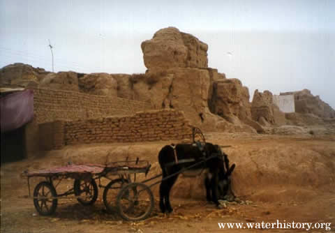
Provence). The Turpan area is historically significant because nearby Gaochang (now a ruin,
see photograph 1) was once the Uyghur capital and an important staging
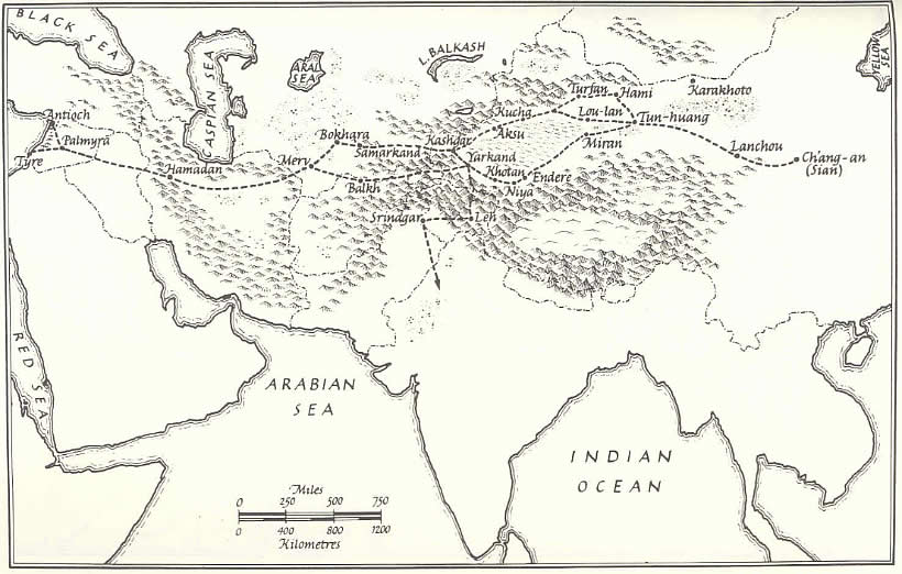
area on the Silk Road. Silk RoadTurpan was once one of the crossroads of central Asia. Historically, it was a strategic stop on the
overland trade route linking China with India, Persia, and Rome (see illustration 1).
Because many of the traders carried bales of silk–China's most–famous export–the entire route became known as the
Silk Road (or Route). But this great trans-Asian highway carried much more than just silk. The China-bound
caravans were loaded with gold and other valuable metals, woollen and linen textiles, ivory, coral, amber,
precious stones, and glass (which was not manufactured in China until the 5th century AD). Caravans
leaving China carried furs, ceramics, lacquer, and bronze objects such as belt buckles, weapons, and mirrors.
The Silk Road was not one route but a series of caravan trails which, at the extremes connected Xi'an in China
with Rome in Europe. The Road hit its peak during the 7th and 8th century AD. 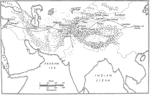
Illustration 1. Main routes of the old Silk Road (from Hopkirk).
 | Click on the image for a larger version. |
Culture and religion also moved along the Silk Road. Before Islam established a firm grip on central Asia,
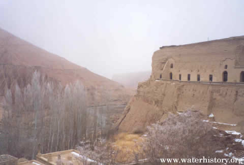
the Uyghurs practiced Buddhism, Manicheanism, Nestorian Christianity, and other religions. Buddhism came north
from India across the Karakoram Range. Extraordinary examples of this culture were found in caves at Bezeklik,
near modern-day Turpan (see photograph 2). The Manichean faith arrived from
Persia and Nestorian Christianity from Asia Minor. The former was founded by Manes in the 3rd century
AD. To escape persecution, many Manicheans moved into central Asia. Until German archaeologists unearthed whole
libraries in the Turpan area, this creed was thought to have no literature. The Nestorians, outlawed by the
Council of Ephesus in 5th century AD, fled eastward. Because so many of its adherents were traders
and missionaries, the creed eventually took root along the Silk Road. Nestorian manuscripts were discovered at
the Gaochang ruin in the early 20th century. All three cultures were extinguished from central Asia
by the tidal wave of Islam, with Tamerlane driving the final nail in their coffin in the 14th century. One of the major obstacles along the Silk Road was the Taklamakan Desert, which has one of the world's
most inhospitable climates. Caravans skirted this oval-shaped impediment by going around either the northern
or southern edges. Turpan was located on the northern route (see illustration 1). The Silk Route was dependent for both its existence and survival upon a line of strategically situated
oases which hugged the perimeter of the Taklamakan Desert. In turn, these oases depended for their survival
upon the glacier-fed rivers flowing down from the vast mountain ranges which form a horse-shoe around three
sides of the great desert. As the Silk Road traffic increased, these oases began to rank as important trading
centers in their own right and no longer merely staging and refueling posts for the caravans passing through them. TurpanTurpan lies in the second deepest inland depression in the world, with more than 4,000 sq. kilometers of
land situated below sea level. Anciently called, 'Land of Fire,' it has recorded some of the hottest summer days
in China, with temperatures as high as 130 degrees F. The Chinese administrator Aitchen K. Wu (Turkistan
Tumult (1940) as quoted in China: the Silk Routes, p. 231) passed through Turpan in 1933 and commented: The market often goes on all night long–while in the daytime the streets are deserted,
every one having 'gone to the earth' in caves . . . The hot wind is worse than anything that can be imaged,
shriveling the skin, scorching the eyes; and the direct rays of the sun carry death. It is a proverbial saying,
not much exaggerated, that the people bake their dough cakes by sticking them on the walls of the huts.
Mildred Cable and Francesca French, two intrepid missionaries who spent many months in the region during the
1920s and '30s, describe the oasis vividly in their book The Gobi Desert (1942) as quoted in
Foreign Devils on the Silk Road, p. 113: . . . Turfan lies like a green island in a sandy wilderness, its shores lapped by grit and
gravel instead of ocean waters, for the division between arid desert and fertile land is as definite as that between
shore and ocean. Its fertility is amazing, and the effect on the traveller, when he steps from the sterility and
desiccation into the luxuriance of Turfan is overwhelming.
The area's specialty is grapes, and many farms have drying towers for turning them into raisins. Turpan's
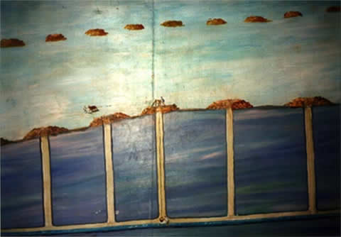
greenery owes its existence to the underground channels called karezes (or qanats). These underground tunnels rate
as one of Asia's more intriguing and historic public works activities (see photograph 3).
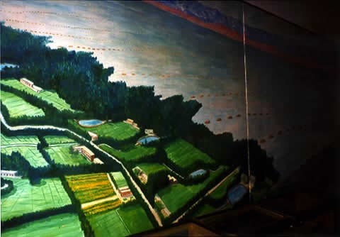
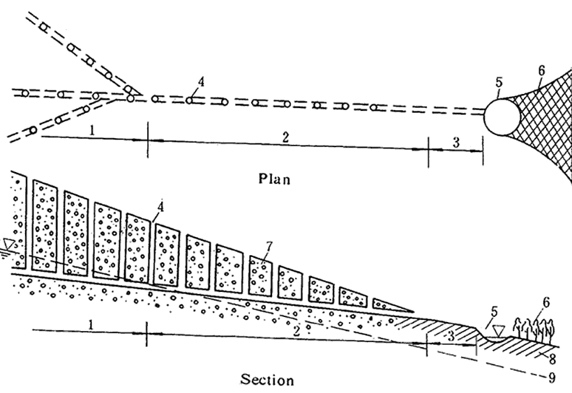
Uyghur and Chinese versions of karez technology date back over 2,000 years ago. KarezA karez is a horizontal underground gallery that conveys water from aquifers in pre-mountainous alluvial
fans, to lower-elevation farmlands (see illustration 2). The water for the
karez is provided by the mother well(s), which is sunk into the groundwater recharge zone. A karez transports
water underground, usually surfacing in cultivated areas (see photograph 4).
Putting the majority of the channel underground reduces water loss from seepage and evaporation. A karez is fed
entirely by gravity, thus eliminating the need for pumps. 
Illustration 2. Schematic of a Karez Project:
(1) Infiltration Part of the Tunnel
(2) Water Conveyance Part of the Tunnel
(3) The Open Channel
(4) Vertical Shafts
(5) Small Storage Pond
(6) The Irrigation Area
(7) Sand and Gravel
(8) Layers of Soil
(9) Groundwater Surface
| Click on the image for a larger version. |
Several theories have been made concerning the origins of Turpan's karez technology. It was: (1) imported from
Persia; (2) locally developed and refined through long-term experience; and (3) developed elsewhere in China and
then imported (ie. Longshouqu Canal project). Some combination of 1 and 2 seem the most probable. In seems
likely that the karez concept moved north and east from Persia along the Silk Road. In 1845, Lin Zexu was banished to the Turpan area. He was deeply impressed by the karez technology and
encouraged its spread to other areas. Under his leadership more than 100 karezes were constructed. Statistics for
1944 show that there were 379 karezes in the Turpan area. By 1952, there were 800, with a total length of 2,500 km,
equivalent to the length of the Grand Canal. Today there are over 1000 karezes in the Turpan area. AcknowledgmentPhotographs 3 and 4 were taken
by the author at the Karez Museum in Turpan. ReferencesChinese Hydraulic Engineering Society, 1991. A Concise History of Irrigation in China (on
occasion of the 42nd International Executive Council Meeting of ICID, Beijing), April, p. 29-30. Hopkirk, Peter, 1980. Foreign Devils on the Silk Road, The University of Massachusetts Press, Amherst. Neville-Hadley, 1997. China: the Silk Route, Cadogan, London. Wulff, H.E., 1988. "The Qanats of Iran," Scientific American |
|
|