Moroccan Khettara
AbstractA 300 km network of khettara (qanat) subsurface irrigation channels was excavated in the Tafilalt
basin beginning in the late 14th century. More than 75 of these chains provided perennial water following
the breakup of the ancient city of Sijilmassa. Khettara continued to function for much of the northern
oasis until the early 1970s, when new technologies and government policies forced changes. Data on origins,
maintenance, and current use were collected from archival sources, aerial photographs, Landsat imagery,
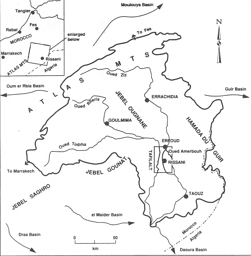
and from interviews. IntroductionIn southern Morocco, on the margins of the Sahara Desert, lies the Tafilalt oasis, a historically
important caravan crossroads and trading center (Figure 1). Sijilmassa (A.D. 757-1393), the great city whose
remains lie in the center of the Tafilalt (near the modern town of Rissani), was one of the earliest Islamic
cities established in Morocco, and it played a crucial role in the gold trade from West Africa to the Islamic
world during the medieval period. After the fall of Sijilmassa the Tafilalt continued in different form,
ruled by the Alaouites who expanded the infrastructure through a large-scale irrigation network of dams and
canals off the oueds (larger river channel)Ziz and Rheris (Lightfoot and Miller, 1996;
Margat, 1959). Surface water for these canals is supplied by runoff from the Atlas Mountains, which
increases during the mediterranean-like winter experienced in the mountains, wanes in early summer, and is
generally absent until autumn rain and winter snow return. Some traditional irrigation in the Tafilalt has been of the pot-watering type, using water hoisted by
camels or donkeys from large public wells. Some crops are still raised today by planting in fallow lands during
the more rainy months of the fall and winter, especially at the periphery where land is otherwise unusable
because of insufficient water. However, even during wetter months rainfed agriculture is marginal. Crops can
be dependably produced only with irrigation. Beyond the river valley oases spreading south and east of the
Atlas Mountains, and beyond the margins of the Tafilalt Oasis, farming is absent. Irrigation has mostly been made possible through the use of earthen canals (seguias), and there is a
very dense and intricate network of seguias in the Tafilalt. Most canals were traditionally filled with water
diverted from the larger river channels (oueds or wadis), or from small reservoirs - intermittent pools of
water - impounded behind a series of low-water dams across the oueds Rheris and Ziz. The channel which slices
through the heart of the oasis, today called the oued Ziz, is itself a large primary canal built sometime
after the mid-11th century by diverting water from the original or true Ziz, itself known as the Amerbouh in
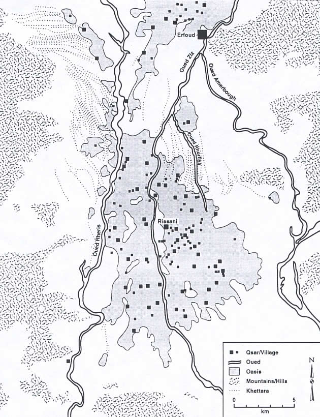
this stretch today (Lightfoot and Miller, 1996; Margat, 1959). Remains of the now- refashioned diversion dam
lies in the Ziz channel near Erfoud
(Figures 1 and 2).
Eleven smaller dams on the Ziz, and two on the oued
Rheris, were built and/or refashioned in this region by Sijilmassians, Alouites, and the colonial French. All
of these ancient and historic dams have now silted up or breached and are useless for irrigation. In the
northern part of the Tafilalt, water for irrigation canals was often provided by khettara
(qanats), which will be discussed in detail
in the next section. 
Figure 1. The Tafilalt oasis, Rheris/Ziz basin, southern Morocco.
 | Click on the image for a larger version. |
Figure 2. Qsour and khettara in the Tafilalt basin, Morocco (Data from
Margat, 1961; satellite imagery, and fieldwork interviews).
| Click on the image for a larger version. |
The availability and distribution of water in the Tafilalt changed dramatically after the 1971 opening
of the Hassan Addakhil dam near Errachidia, impounding the oued Ziz about 75 km north of the Tafilalt
(Figure 1). Water from the oued Ziz used to flow unimpeded into the Tafilalt basin and provided the primary
source of water for irrigation since the time of Sijilmassa. Floods were not uncommon. Now water from the
reservoir is released through government canals only three to four times per year, depending on reservoir
recharge, with each water release lasting 20 to 23 days (to allot 10-12 hr of water flow per village) and
timed to correspond to more critical periods in the growing season (Miller, 1996) . This water contributes
to the irrigation of about 9400 ha, more than 75% of all arable land currently used in the Tafilalt, but the
water is so thinly spread that no longer can fields be irrigated solely with water from the oued Ziz. Because of their ubiquity, private and cooperatively owned diesel-pumped wells have now become most
important to Tafilalt irrigation. The first private motor pump was installed on a well in 1965 (information
from the Office Regional de Mise en Valeur Agricole du Rissani). Seven larger, public pumps, irrigating about
950 ha, had been installed by the French in the 1930s. Some of these public tube wells were deepened after
the early 1970s, when the water table began to fall. One was even extended twice but again went dry and was
abandoned in 1985; the remaining six are still in operation. Today there are almost 750 private diesel-pumped
wells operating. Khettara in the TafilaltHistory of khettaraAn impressive 300 km network of khettara was excavated in the Tafilalt basin beginning in the late
14th century. Some of these tap into the aquifer at the base of mountains along the western margin of the
oasis. Others exploit the shallow water tables adjacent to major stream channels which pass through the
basin. Eighty of these chains provided perennial water for 28 qsour (villages; sing. qsar) in the northern
part of the oasis (Figure 2). The qsour andkhettara simultaneously developed following the breakup of
Sijilmassa (Lightfoot and Miller, 1996). Qsour in the central and southern oasis-where the water table was
and is much deeper-continued to rely on the same sources of water (wells and surface canals) for irrigation
and drinking water that sustained Sijilmassa. It is possible that khettara first came to Morocco from the Middle East following the Islamic
revolution; the pattern of diffusion closely follows the historic dispersal of Islam. However, it is not
certain if this technology was introduced by Muslims first to Morocco and later to Islamic Spain, or whether
it first swept into Islamic Spain from North Africa, and then diffused back into Morocco (Goblot, 1979;
Joffe, 1992). It appears that qanat technology had earlier diffused to Roman Spain from the Near East where
the Romans, presumably borrowing Persian technology, had built and used qanats in Jordan and Syria, so there
could have been an Iberian precedent to Morocco's filtration gallery systems (Fleming and Barnes, 1993;
Glick, 1979). The Moroccan hearth for khettara was the Haouz Plain around Marrakech, where khettara were being built
by the early 12th century, followed by the Sous Valley of southern Morocco (English, 1968; Goblot, 1979;
Joffe, 1992). Although the technology was surely known in Sijilmassa by at least this time (if not earlier),
khettara did not appear in the Tafilalt until late in the 14th century, shortly after the fall of Sijilmassa
(Lightfoot and Miller, 1996). Fourteen medieval accounts of substantive interest - dating from the 9th-14th
centuries - describe Sijilmassa and its environs, yet make no mention of khettara in this area, and most
Tafilalt khettara irrigated agricultural fields which lay outside of the original Sijilmassa-era fields
(Lightfoot and Miller, 1996). Tafilalt khettara are closely associated with post-Sijilmassa qsour, which were
only built after the fall of the city as its inhabitants divided along family/clan lines and dispersed across
the oasis (Lightfoot and Miller, 1996). It is possible that the adoption of this new water technology even
facilitated the disintegration of Sijilmassa or, at least, made the devolution from central city to dispersed
villages both thinkable and achievable for the northern Tafilalt. Khettara technology accords well with the
layout of scattered qsour, each with its ruling lineages and mechanisms for organizing labor at a more localized
level (Lightfoot and Miller, 1996). Many of the khettara are flamed after the qsour which built and used them.
Many more are named after Alouite kings who ruled the Tafilalt after the fall of Sijilmassa. Therefore, networks
of dispersed villages with associated khettara appear to have emerged in the Tafilalt in the late 14th through
the 16th centuries; a few of the Sifa district (northwest Tafilalt) khettara being originally constructed as
late as the 1730s (Margat, 1961). Khettara continued to provide the only reliable irrigation water for north Tafilalt qsour until the early
1970s, when new technologies and government policies forced changes in traditional water management. Insufficient
water (from the dam) and non-sustainable methods of groundwater use (overuse of diesel pumps) have, since the
early 19705, resulted in a dramatic lowering of the water table underlying the oasis. These modern water
technologies, because they are proffered and subsidized by the government, continue to replace the few remaining
khettara, which are abandoned as the water table drops. Siting and maintenance of khettaraConstraints of geography have allowed only 28 of the 132 qsour of the Tafilalt to construct and utilize
khettara. For these qsour khettara became essential to their survival. Qsour and khettara have functioned
symbiotically. With one exception, all qsour with khettara are in the north of the Tafilalt, where the water table
has always been most shallow, and khettara mother wells did not have to be sunk into the basin alluvium more
than a few meters. Until a generation ago, agricultural maintenance in general was most often the task of the haritin, a
social class held as chattel. An entire class of haritin, known as "khattater" (from "khettara") were
specialists in the difficult and dangerous work of khettara maintenance. This is analogous to the special
"mughanni" class of qanat builders in Iran, except that the "khettater", and haritin in general, were viewed
with contempt, while the "mughanni", in spite of their low caste and crude work, were (and are) held in
esteem for their skill and performance (English, 1968; Smith, 1953). The haritin caste has now been liberated,
and while many still live in the Tafilalt and may now own land, they are no longer responsible for khettara
maintenance. This change in social roles, and not only the loss of groundwater, has contributed to the abandonment
of khettara over the last generation. Those khettara that are still active are maintained by all qsar inhabitants
and sometimes by friends and family from neighboring qsour who help with labor, receiving either cash or
returned favors. Typically, each family will donate one workman per day during maintenance operations, which includes
cleaning sediment out of the subsurface channel as well as deepening the mother well and/or intermediate shafts.
In order to encourage the exploitation of every possible water source, the government of Morocco, via the
Errachidia agricultural office (and Rissani extension office) makes available small grants to fund the
regular maintenance of productive khettara (at least since 1975, when the Rissani office was established).
The agricultural office also provides khettara workers with education, training, and equipment (e.g. shovels,
ropes, and sump pumps to remove water from khettara upstream from the work site) and gasoline (for the pumps)
to aid in the cleaning effort. Funding is contingent on the perceived importance and benefit of the project. Although requests for
assistance for installing diesel-pumped wells may or may not be approved, khettara requests are almost always
granted, as they (unlike pumped wells) are seen as providing benefits to agriculture without preying on the
groundwater of neighboring mother wells or pumped wells. If granted, funds are used to pay workers from the
qsar that owns the khettara (about 30 Dirhams per day in 1992), or to pay workers hired from other qsour. Khettara are employed either as primary irrigation sources or at least to supplement the water
from mechanized wells and government canals. Qsour which used to operate khettara have abandoned theirs
only because "the water has gone dry". Usually this means that water no longer flows through the khettara
because the water table has dropped, but it may also mean that an earthquake or flood has damaged the
subterranean conduit, or the tunnel has collapsed, or side walls have blown out into a neighboring tunnel
as the result of dynamite (occasionally) used during cleaning operations. Khettara in a Modern WorldThe competition between traditional and modern water systems is both environmental and cultural.
Environmentally, diesel-pumped wells and government canals have led to the abandonment of a sustainable technology
in favor of systems which are capable of providing greater quantities of water but are not sustainable. Culturally,
the adoption of newer technologies has led to the abandonment of traditional technologies like khettara, altering the
land use patterns which evolved through the historic reliance of villages on khettara. There has been some loss of local
control over water resources, because much of the water villages need comes only from the Errachidia reservoir and
drinking water pipes, both regulated by the government. Khettara are qsour operated and collectively maintained, and
intricate relationships have evolved to manage them and distribute their benefits according to each shareholder's inputs
of land, labor, tools, and money. Diesel-pumped wells are often privately owned and, as a result, the traditional ties
that bind village society are breaking down. Non-farm sources of income continue to draw young men away from villages
and out of the oasis, disrupting the social organization of khettara systems. Furthermore, the traditional source of
wealth in the oasis, trade in dates, has been irreparably altered. Only 60% of the palm trees in the Tafilalt still
produce a date crop today. The others no longer produce dates or have died as a result of periodic date blight and/or
sustained desiccation. There were originally 80 khettara in a 300 km network providing water for 28 qsour in the northern
Tafilalt. Today there are only 19 khettara in a 90 km network watering 12 qsour (possibly as many as 36
khettara for 16 qsour, if all of the galleries between Sifa district and Jorf in the northwest Tafilalt,
active in 1970, were still active; a few of these still flow, but some are now dry, and the status of
each of these 17 khettara between Sifa and Jorf is not known). All 80 khettara originally irrigated about
3000 ha of the Tafilalt oasis. This is about 14% of the potentially arable land in the Tafilalt, and about
20% of the roughly 14,000 ha actually farmed at any time. The last of the khettara will dry up in the near future, as the water table becomes so deep that
"following the water" by extending the depth of mother wells would necessitate the excavation of new
horizontal shafts; in essence, excavating new khettara from source to terminus, parallel to the old galleries
but at greater depth. This would prove prohibitively labor-intensive and expensive. SummaryCommunities and cultures dependent on irrigation have forever improvised, borrowed, and improved
their water management technologies in an effort to expand production or at least maintain and more wisely
use existing stores. Today, more than ever in the past, injudicious attempts to expand the use of surface
and groundwater, without regard to the sustainability of withdrawal, are depleting groundwater resources
and feeding social and environmental instabilities. In the Tafilalt oasis, khettara irrigation is being sacrificed in the drive to expand water supplies
to meet the needs of enlarged agricultural industries upstream, and a growing population throughout the
region. Traditional water technologies may not be able to keep pace with growing demand, but are usually less
expensive to operate and allow farmers and village cooperatives more direct control over the supply and
distribution of their water. Newer technologies have been designed to deliver greater quantities of water, and
may provide a more reliable source of water less susceptible to natural fluctuations in water regimen, yet
withdrawal rates often exceed natural supplies or recharge. But 'out with the old and in with the new' has
long been a trend everywhere, and must be as economies develop and populations expand, increasing the need
for more water and other resources. In the Tafilalt, however, it is not only the traditional water systems
that are marginalized in the march to modernization; a whole oasis is being forsaken. Khettara abandonment
is merely the bellwether of a moribund oasis.  | This article is excerpted from "Moroccan Khettara: Traditional Irrigation and Progressive Desiccation,"
Geoforum (27:2), 1996, pp. 261-273. |
ReferencesEnglish, P. W. (1968) The origin and spread of qanats in the Old World, Proceedings of the
American Philosophical Society, 112,170-181. Fleming, D. and Barnes, N. (1993) The worldwide distribution of filtration gallery systems and the
social mechanisms underlying their construction and management, Culture and Environment: A Fragile Coexistence,
Proceedings of the 24thAnnual Chacmool Conference, 1991, Calgary, Alberta, pp.
363-369, University of Calgary. Glick, T. F. (1979) Islamic and Christian Spain in the Early Middle Ages. Princeton
University Press, Princeton. Goblot, H. (1979) Les Qanats: Une Technique d'Acquisition de I' Eau.
Mouton, Paris. Joffe, G. (1992) Irrigation and water supply systems in North Africa,
Moroccan Studies, 2,47-55. Lightfoot, D. R. and Miller, J. A. (1996) Sijilmassa: The rise and fall of a walled oasis in medieval
Morocco, Annals of the Association of American Geographers, 86, 78-101. Margat, J. (1959) Note sur la morphologie du site de Sigilmassa (Tafilalt),
Hesperis, 46,254-260. Margat, J. (1961) Carte Hydrogeologique au 1/50000 de la Plaine du Tafilalt.
Notes et Memoires du Service Geologique, Service Geologique du Maroc, Rabat. Smith, A. (1953) Blind White Fish in Persia (Chapter 3).
George Allen and Unwin, London. |
|
|