|
|
|
|||||||||||
|
|
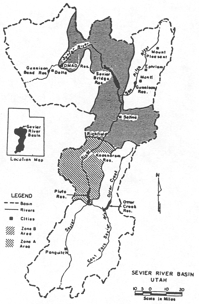
AbstractThe spillway of the DMAD Dam in central Utah failed in 1983. The sudden release of some 17,000 acre-feet of water caused millions of dollars in damages and resulted in litigation that required years to resolve. The failure itself resulted from inadequacies in both the spillway design and the operation of the river system. The engineering issues which developed during the flooding are raised in this paper. Several suggestions for modifying current engineering practice for these kind of problems are made. IntroductionOn June 23, 1983 the emergency spillway of the DMAD Dam, 5 miles northeast of Delta, Utah failed following four months of record runoff. The resulting surge of water destroyed or over-topped every road, railroad, and irrigation channel crossing along the river alignment. It forced the breaching of the Gunnison Bend Reservoir, 8 miles downstream, and it flooded the town of Deseret, as well as hundreds of acres of farmland. Litigation undoubtedly established the responsibility for the losses. Meanwhile, the failure raised a number of important water management issues. The DMAD Reservoir is a small storage and regulating facility in the lower Sevier River Basin (Figure 1). If the physical and operational aspects of the system had been major considerations in the DMAD design, it is unlikely that a failure of this magnitude would have resulted. The flooding conditions in 1983 exceeded the 10,000 year flood event and were dealt with by improvisation and innovation. In order to appreciate the significance of the situation, it is necessary to describe the setting in which the problem developed. Then, an examination of the dam itself is made to illustrate the operational and structural deficiencies. Finally, this paper identifies some of the engineering lessons learned as result of the disaster. Description of the SystemBetween the initial settlement of the Sevier River Basin in the early 1860's and the first serious drought in the 1890's, agricultural waters were supplied by small check-dams in the river. When the drought period ensued, many of these diversions were able to divert the entire discharge. Lower users were entirely dependent on return flows to satisfy irrigation demands. Three developments resulted from this period which bear on the events of nearly a century later. The first was an ambitious, privately financed program to construct reservoirs to capture off-season flows. Gunnison Bend Reservoir (4500 acre-feet) was finished in 1890, Otter Creek Reservoir (52,600 acre-feet) in 1898, and construction of the first 104,000 acre-foot segment of Sevier Bridge Reservoir began in 1903. This storage was intended to develop supplemental water supplies for existing areas. In about 1906, a series of high flow years occurred which prompted reservoir development for additional lands. As a result, Sevier Bridge was enlarged to 236,000 acre-feet, and Piute reservoir (72,000 acre-feet) was constructed. In the end, the Sevier River system had 40% more storage capacity than the average annual flow. Safety structures were generally broad crested weirs with crest elevations very near the design level of the reservoir. These structures afford practically no operational freeboard during a high flow period. The outlet systems at the reservoirs were designed for irrigation release, having as little capacity as 5 to 10% of the design flood discharge. Consequently, for the design flood condition the reservoir systems had minimal regulating capability. The second effect of the 1890's drought was the establishment of the various water rights. In the 1901 to 1906 period, the water resources were divided among the various claimants, but in two different regions of the basin shown in Figure 1. Thus, a single, interdependent hydrologic system was legally divided into two independently managed systems. In 1936, the system was placed under common decree to resolve conflicts between the two sections, but in effect left the operation of the system in two separate components. There was no provision to operate the system elements conjunctively in the event of a major flood. Finally, a modification to the 1936 decree was made to allow individual users to carry-over water from one year to the next. Prior to this, any unused water was reappropriated each spring. Rather than lose what was culturally considered a scarce resource, many irrigators used water unnecessarily to avoid losing their entitlements. Afterwards, the major reservoirs become long term carry-over facilities and each entitlement thus had an economic interest in conserving water. Therefore, the operational bias became one of releasing non-demand flows only after an emergency was in progress, and then the spillway design, particularly at DMAD, prevented controlled releases of sufficient quantity to protect the facility. The unused capacity of the reservoirs was quickly eliminated under this scenario, thereby providing minimal stabilization of flow fluctuations. These practices have been remarkably successful in conserving water. Until 1980, the system was able to retain the annual flows in all but three years. As 1983 demonstrated however, they are not desirable during flooding. In summary, the Sevier River system developed as an exclusive water supply for irrigated agriculture. Reservoirs were constructed to conserve and stabilize the flows for delivery, not to protect against the possibility of flooding. The management of the system as dictated by decree was expressly in conflict with flood control requirements. Further, the system was organized and operated as two distinct units, thereby prohibiting the system scale coordination necessary during critical flood stages. Until the Utah legislature authorized the State Engineer to assume emergency control in 1984, there had not been a central clearinghouse for communications or decisions. Figure 1. The location and setting of the DMAD Dam in the Sevier River Basin.
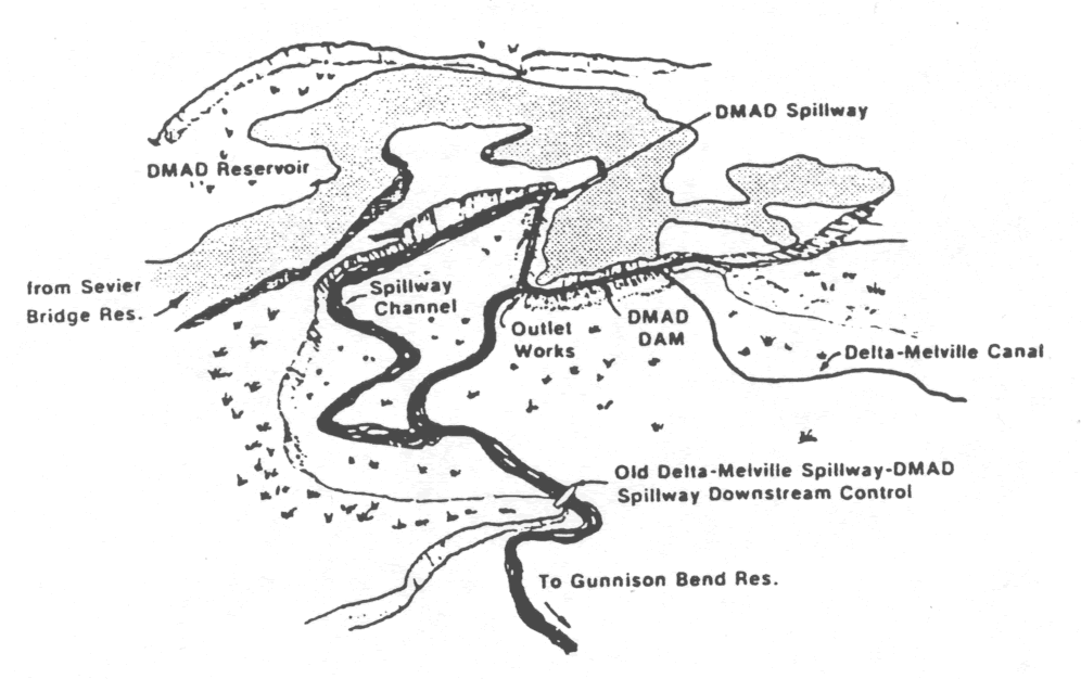
The DMAD DamThe DMAD Dam and Reservoir (Figure 2) was a cooperative project of the four local irrigation companies (Delta, Melville, Abraham, and Deseret Companies, and thus the name of DMAD). The Abraham and Deseret Companies own and operate the Gunnison Bend Reservoir downstream of DMAD (Figure 1) and have a first priority right to the first 9,300 acre-feet of winter flows below Sevier Bridge Reservoir. Prior to DMAD, the limited capacity of Gunnison Bend forced most of this winter flow to be used for irrigation in the off-season or lose the water to junior appropriators for storage in Fool Creek Reservoir. When the four companies joined and built DMAD, it afforded Abraham and Desert better control of their water and it gave Delta and Melville substantially better regulation during the irrigation season. The Delta and Melville systems were originally supplied by a check-dam near the present dam site which was actually regulated at Sevier Bridge Reservoir about 3 days of river travel time upstream. It is important to note that the original Delta-Melville diversion was protected by a spillway which later became the downstream control on the DMAD spillway some 3/4 mile upstream. Figure 2. Site Layout of the DMAD Reservoir.
The flood plain on which the DMAD Dam was constructed is a narrow eroded channel through the bend of prehistoric lake Bonneville. Being near the entrance to the valley, the flood plain is characterized by distinct layers of soil, sand, and gravel. Of specific importance is a 3 to 9 foot layer of fine sand material lying 9 to 15 feet below the surface. The dam itself is a "L" shaped earthen fill embankment extending 900 feet in the north south direction across the river channel and then 1,500 feet easterly. The spillway is at the east end of the dam. The capacity of DMAD Reservoir is 11,000 acre-feet at the 4666 foot elevation. This is also the elevation of the spillway crest. The crest of the downstream control structure was at the 4647 foot contour and the natural river channel below lays at the 4632 foot level. From the base of the DMAD spillway stilling pool (4656 foot elevation) to the channel below the old diversion structure, there were 24 feet of fall in 3/4 mile. Geologic studies located the fine sand layer at the 4632 to 4637 foot level and therefore within the erodible horizon. It is difficult to examine the hydraulics of this situation without being somewhat critical of the design. Because of the unstable, dangerously erodable subsoils in the flood channel, the safety of DMAD Dam rested on its downstream control - a structure constructed in 1912 and having far less capacity than the DMAD spillway. During the periods of flooding, no maintenance access was possible to the structure and inspections failed to alert the users of this principal danger to DMAD. Flood Events of 1983In the fall of 1982, reservoirs along the Sevier River were nearly filled to capacity with carry-over storage. Late summer and early fall precipitation had substantially reduced irrigation demands. As the fall precipitation continued at above normal levels, it was evident water would necessarily need to be wasted to the old Sevier Lake, the historical end of the river. Because there was no way to determine what the future weather patterns were likely to be, the management decisions were made on a very short term basis. The runoff was judged somewhat by the historical record, particularly at Gunnison Bend Reservoir since it had the longest period of use and proven adequate during previous flooding. The addition of the reservoirs upstream gave some false assurance that the structures along the river would be sufficient to prevent any major losses. Release of water to Sevier Lake commenced November 11, 1982. By late January 1983, releases were being made up to the capacity of the river channel below Gunnison Bend and no reserve capacity was being created in any of the reservoirs. At DMAD, the flood flow exceeded the outlet capacity on February 18th and began over-topping the spillway. Interestingly, as the flows through DMAD increased, the backwater control at the old Delta-Melville diversion submerged the DMAD outlet gates thereby reducing the regulated releases even further and increasing the spillway flow. The inflexibility to manage the flooding at DMAD Dam due to the decreased outlet capacity became one of the most limiting problems on the river system. Various highway and crossing structures over the river channel below Gunnison Bend Reservoir constricted the river flow and had to be removed or replaced. Transportation authorities were reluctant to destroy expensive structures until absolutely necessary, thus complicating the operational problems of DMAD. The record discharge at Deseret, downstream of Gunnison Bend, was 1,650 cfs in 1922. This flow was exceeded in March at a time when the snow pack was rapidly increasing. By May 1st, it was reasonably certain that flows would exceed the capacity of nearly all of the reservoir spillways at their rated levels, thereby placing each reservoir in some jeopardy. It was necessary to construct additional spillway structures, modify the hydraulics of those existing structures that could be reached, and divert as much water as possible into the irrigation systems for disposal on land and into the drainage channels. In the last week of May, the weather turned from record cold to record warm. The first surge of water eliminated many upstream diversions. This added to downstream problems by preventing substantial irrigation diversions from being subtracted from the flood discharges. In February the release of less that 1,000 cfs was causing major problems along the lower stem river crossings. By May and June, following removal of the most restricting sections and substantial modification of other control structures, 4,500 cfs were being bypassed. The highest flow ever recorded in the system prior to 1983 was 2,260 cfs. In 1983, inflows to Sevier Bridge Reservoir exceeded 6,500 cfs. On a different scale, the historical maximum release of Sevier Lake was 173,000 acre-feet. In the 1983 water year, the runoff into the normally dry lake bed was expected to exceed 700,000 acre-feet when the records were finalized. The average annual release from Sevier Bridge was 140,000 acre-feet for irritation. The 1983 release approached 900,000 acre-feet. The DMAD Spillway CollapseAfter the first of March, the entire flood plain below DMAD Reservoir was inundated. The only location where both sides of the river channel could be approached for maintenance was at the spillway itself. The reservoir water level was nearly a foot higher than the wing walls of the spillway and only the draw down as the flow approached the spillway crest kept the levels from over-topping. The volume of water behind the dam was 150% of the designed full level. For weeks the old spillway below the dam acting as the downstream control was completely submerged. The change in water level at this point was at least 20 feet and tremendous scour was occurring in the plunge pool. On June 15th, the old spillway structure sheared at its wingwalls and was washed into the river below. With the downstream control gone, a cascade formed in the soft and saturated soil to dissipate the gradient and began eroding rapidly towards the DMAD spillway, often by as much as one foot per minute. The only hope of saving the reservoir was to control the erosion at the spillway when the cascade reached it. Although many suggestions were made for establishing a temporary downstream control, the instability of the flood plain made it impossible except where work could be undertaken on both sides of the flow. After being grossly over-filled for nearly four months and absorbing the surging and pounding of the overflows, the unusual fact was that the spillway was still in place in early June. On June 23rd the cascade reached the stilling basin. Unfortunately, the softest section of soil was just downstream of the spillway and before the scour could be stabilized, the erosion weakened the east wing wall. The spillway structure pivoted on its axis and moved into the downstream pool. The estimated flows in this reach of the Sevier River over the next three hours were about 30,000 cfs, resulting in more than $3 million in structural damage and maybe that much in personal property losses. The Technical LessonsThe issues that bear most heavily on the post-mortem analysis of the DMAD incident were common flood control philosophy. If so, then this paper can be viewed as a renewed call to correct some serious deficiencies. The following six lessons are identified: (1) a centralized management similar to that needed to resolve conflicts during water shortages should be functional during flooding; (2) contingency planning should be undertaken at the design stage of the crises; (3) the discharge calibrations developed for emergency structures should be accurate; (4) provisions for emergency maintenance should accompany the structural plans; (5) the design and conveyance and transportation crossings should be consistent with the reservoir and diversion structures; and (6) spillways in largely irrigation systems should have substantial regulating capacity. Centralized Crisis ManagementEarlier descriptions of the DMAD problem noted the complications associated with unexpected flows reaching the three reservoirs in the lower Sevier River system. The fact that some of these unexpected flows were due to unreported, uncoordinated releases from upstream reservoirs is significant. The variations due to snow melt and runoff threatened the safety of all of the structures. The value of centralized management in emergency situations is that the operation of various components of the system would not allow timed releases that compound the difficulties already being experienced until no other options are available. At each of the lower system reservoirs, day to day management at the most dangerous times were affecting only 1 to 5% changes in the flows. Within this range, any undetected and any uncompensated for increase over a 24 hour period would have caused over-topping of the dams and control structures. The true safety of the system depended on the dampening capabilities of the major reservoirs to smooth short term fluctuations in the runoff pattern. As mentioned earlier, inflows to Sevier Bridge reached about 6,600 cfs, but outflows were held to no more than 4,900 cfs. Contingency PlanningThe authors also question the practice of design without determining the outcome of the possible design failure. Users in many irrigation systems seldom participate in the details of design, most simply assume control when the construction is completed. On most projects of any age, it is likely that operating personnel have changed several times and very little of the accumulated experience is transferred from person to person. Since the designers have not considered the contingency scenario, a framework for decision making is absent. The only basis for dealing with emergency situations is one or more of the following: (1) the trends in the historical record which may prove completely misleading; or (2) "seat of the pants" judgment which is founded in entirely different experience. When the possibility of the DMAD failure became a distinct probability with the loss of the downstream control, a series of critical questions were raised. The first was what people and structures were in the most danger. Then, how long would the surge of water take to reach important points downstream and how would the flood hydrograph evolve with distance from DMAD. What immediate actions should be taken to minimize damage was discussed in the environment of impending disaster and could not possibly consider the complex hydraulics involved. The collective engineering experience indicates without question that structural failure under the adverse design level conditions was a distinct possibility and should be a final function of that process. To illustrate the need for contingency plans, the events immediately following the DMAD spillway failure can be examined in closer detail. When the spillway moved out of the dam anchorage and released the contents into the flood channel, local authorities decided to cut a breach in the Gunnison Bend Reservoir below. The intent was to create as much storage as possible in this region of the system, protected the diversion structures at the dam, and minimize the flood wave property surrounding the reservoir. It was not known how long the flood wave would take to arrive at Gunnison Bend, nor how fast the flow would build up and decline. It was not known what the surge of water from DMAD would do if no action was taken, but it was reasoned that Gunnison Bend would also fail at some point thereby resulting in effectively the same result downstream. Thus, the thinking dictated trying to get some of the local storage into the river channel ahead of the water from DMAD. It was hoped that if capacity at Gunnison Bend could be created, that it would dampen the surge. Some very tentative calculations indicate that if the strategy could have been implemented two hours earlier, the eventual flood stage downstream might have been lowered about two feet. Again, it is not known what benefits a 2 foot change in flood stage would have produced, but in the absence of accurate information local authorities had to exercise their judgment as they could. Accurate Flood Stage Discharge CalibrationsWithout exception, the state-discharge ratings supplied with the spillways and control structures in the system below Sevier Bridge Reservoir were in gross error. A major check-dam upstream of DMAD was nearly lost because its flow rating indicated that it could safely pass the flows known to be in the river. In reviewing this information, it is obvious that standard formulas were applied without any attempt to adjust for local boundary conditions. It is worth mentioning that after a flow passes through several control points and two or three reservoirs, the magnitude of the flow is quickly discernible. Poor flow ratings become obvious, but until the necessary adjustments can be determined, the errors themselves become very dangerous. Accurate flow measurement is absolutely essential to effective and efficient water management whether the conditions are drought or flood. The writers see no reason why these deficiencies should occur, much less be discovered in an emergency situation. Consequently, it is recommended that the calibration of important safety and control structures be re-evaluated periodically. During flood conditions measurements should be a high priority for agencies not directly involved in system management. Emergency MaintenanceAs noted earlier, one of the serious problems associated with the DMAD circumstance was the inability to perform emergency maintenance operations at the height of the flooding because backwater had restricted access. Even had the danger associated with the downstream control at DMAD been revealed in time, the necessary maintenance equipment could not have approached the site. At the DMAD spillway itself, the main hope of protecting it once the downstream control failed was by working at the stilling basin where the velocities and turbulence are highest. As with centralized crisis management, contingency planning, and accurate flow ratings, it is the opinion of the authors that the engineering practice is incomplete unless preventative maintenance has been provided for under the most adverse of conditions. Design of Miscellaneous Control and Access StructuresThe limiting section of a floodway may not always be the reservoir spillway or outlet works. There are apparently different design standards for highway crossings than for the dams themselves. Practically no highway structure below Sevier Bridge Reservoir had the capacity to pass the same flood flows being routed through the reservoirs. Thus they often become liabilities to the river managers. And because they develop substantial backwater, they also pose dangers to the structures and property below. Culverts are particularly troublesome because erosion around their entrances significantly reduces their hydraulic efficiency. The writers believe that some effort should be made to coordinate the design of all flood control structures in a project area in order to eliminate these sort of problems. Spillway Design PracticesThe final issue to be raised in this paper concerns the design strategy for spillways in primarily agricultural systems. In these systems, the capability to regulate reservoir releases whether from the main outlet works or from the spillway is critically important to their principal purpose - to capture and store water for irrigation. The question is how much of the maximum design flood should fall with the managerial range of the operators. The users in the lower Sevier River Basin have tried to have spillway crests located 3 to 4 feet below the reservoirs full level with removable flashboards up to the design full level. But it should be noted, that had the spillway at Sevier Bridge been designed without regulating capacity, it would have been in serious jeopardy. Further, it would not have been able to reduce the peaks in the runoff hydrographs to keep flows from significantly exceeding the design levels of both DMAD and Gunnison Bend Reservoir. Thus, the principal lesson from the DMAD failure is that spillway flow regulation is critically important in routing flood waters through reservoirs. The capability to create capacity during periods when the flooding temporarily subsides depends on being able to maintain outlet flows. Weir type over-flow spillways are relatively sensitive to changes in the elevations of the reservoir and therefore difficult to maintain. Regulation of the spillways also provides the users with the added insurance of maintaining reservoir levels at the rated full level rather than the levels necessary to give the spillway sufficient head to by-pass the flows. |
|
||||||||||||
| Programming and Design by Moki Systems, a Utah Ruby on Rails consultancy with content provided by USBR Provo Area Office. Accu-tech Auto Wisp-router.com |