The Delta Project: Utah's Successful Carey Act ProjectThe Delta Project: Utah's Successful Carey Act Project
In the late nineteenth century, there was a growing interest in western land reclamation.
An important contributor to this interest was the "hype" generated by the Irrigation Congress,
an organization which held its first session at Salt Lake City in 1891. Sponsors of the Congress
sought to channel western public opinion into pressure for the Federal government to aid
development. One consequence of this agitation was the passage of the Carey Act of 1894, which
authorized the transfer of Federal land to arid-region states. The transfer was conditional on
the states arranging for settlement and insuring that the proper irrigation facilities were
constructed. Under the Carey Act, several geographically diverse Utah projects were envisioned
(State Engineer, 1913). Of all the Carey Act projects, the one located near the modern-day town
of Delta was the first to make application and ultimately the only successful attempt. Despite
the Delta project's unique position among Utah irrigation developments, it has been largely
ignored in scholarly studies. The general premise of past historical studies of the Delta area is that successful
settlement would not have occurred without substantial government (Avery and Singer, 1982)
and church (Arrington, 1951) assistance. However, as this paper will demonstrate, irrigation
projects in the Delta area succeeded only after private entrepreneurship took over. It was the
strong will of the local inhabitants, combined with outside private capital, which made
development in the area possible. That is not to say that at times they were not assisted by
church and government sources; but the drive and the desire which allowed the projects to
succeed was always provided from within the area and not from without. In fact, on at least one
occasion, Federal assistance hindered more than it helped. Delta does not fit into the
standard mold for Utah developments and it should not be forced into it. Early Settlement of the Lower Sevier RiverThe Sevier Desert in west-central Utah ranges from semi-arid to outright desert. On
the edge of this desert is the Great Pahvant valley named after the primitive locust-eating
Pahvant Indians. For many years explorers regarded the valley, located in the lower Sevier
River Basin, as inhospitable and uncultivable. But with a great deal of struggle, the area
has been transformed from a barren desert into a productive agricultural settlement. The several accounts of the colonization of the lower Sevier River Basin are in general
agreement. The first area to be settled was the low lands southwest of the present-day
community of Delta. In May 1858 a group of Mormons visited the area; they returned to settle
the next year. A small community was established at Deseret and an adobe fort was constructed
to protect the settlers from Indians. The difficulties associated with maintaining the early irrigation diversion structures
on the Sevier River have been chronicled elsewhere (Arrington, 1951; King, 1947). The location,
however, of the diversion structures has not been adequately addressed. Dudley Crafts (a lifetime
resident of the Delta area, noted water attorney, and local historian) stated in unpublished
notes that the first earthen dam was placed approximately three miles downstream from the
present-day town of Deseret. Several irrigation efforts were made below Deseret but pioneer
statements and archeological remains locate the major effort upstream. The original town of Deseret was located on the south side of the Sevier River near where
the old fort is located. The settlers built homes, cleared farms of brush, and constructed
irrigation systems. An old river channel served as the principal canal. By tracing the old river
channel back to its junction with the present Sevier River channel, the old diversion site can
be located. It was at this site, located northeast of present-day Deseret, that the major dam
building efforts occurred. The site mentioned by Crafts was a diversion dam in the old channel
to regulate into irrigation ditches. In all, five separate attempts at diverting the river were
made during this period. These efforts were typical of Mormon pioneer efforts elsewhere in
Utah (Peterson, 1985): "pioneers had to learn by trial and error. Diversion dams were
installed almost annually." The flooding which occurred along the lower Sevier River in 1983, exposed at least two dams
at the upper site. Many of the rocks, cribs, and pilings are still in place. The fifth dam
constructed at this site in 1864 withstood spring runoff for three years and the dam was
"deemed very secure." But in the summer of 1868 unusually high water caused this dam to fail.
The settlers left the Deseret area with many moving a few miles east to Oak Creek. 
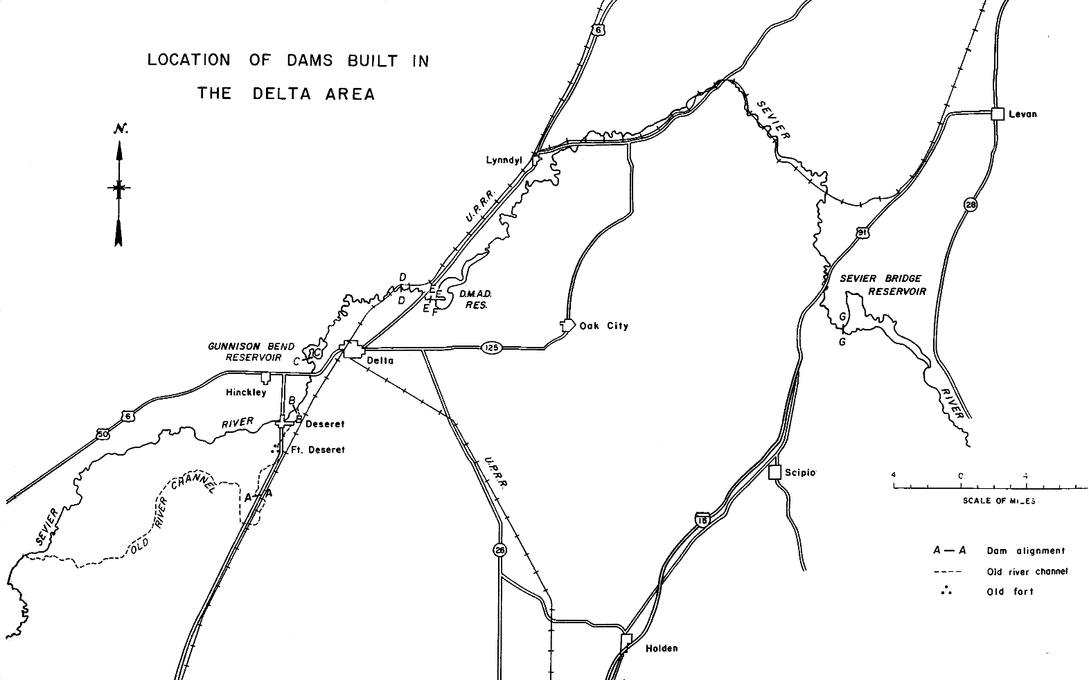
Figure 1.
 | Click on the image for a larger version. |
Table 1. List of Dams Constructed to Serve the Delta Area | Dam | Construction Year | Use* | Alignment** | Comments |
|---|
| Old Deseret Site | 1860 | D | A-A | Diversion from the old Sevier River channel | | Lower Sevier Site | 1860-68 and 1874-84 | D | B-B | Diversion from Sevier River into old channel | | Gunnison Bend | 1880-90 | D | C-C | Constructed by Gunnison Bend Company; later purchased by Deseret Irrigation Company | | Gunnison Bend Enlargement | 1895-98 | D,S | C-C | Constructed by Deseret and Salt Lake A&M companies; the dam at this site is still in use;
it has never failed but was breached in 1910 and 1983 when upstream dams failed; Cropper Cut washed out
in 1909. | | Delta Site 1 | 1909-10 | D | D-D | Spillways on this structure failed in both 1909 and 1910. | | Delta Site 2 | 1911 | D | E-E | This was the diversion structure for the Delta and Melville companies until 1960 when DMAD
dam was built; it was then converted into a drop structure; in 1983 the structure washed out
causing the DMAD failure. | | Sevier Bridge | 1903-08 | S | G-G | The dam impounded approximately 100,000 acre-feet of water; it was probably unsafe. | | Sevier Bridge Enlargement | 1914-16 | S | G-G | This dam is an enlargement of the earlier reservoir; it impounds approximately
236,000 acre-feet of water and is still in use. | | DMAD | 1960 | D,S | F-F | The dam impounds approximately 11,000 acre-feet; its spillway failed in 1983 and was
subsequently rebuilt. |
 | * D = Diversion structure with little or no storage
S = Dam to impound enough water to provide storage
** for location refer to Figure 1
|
The next group to attempt settlement in the area came from the Tintic Mining District.
This group, headed by C. Gilbert Webb, chose for the site of its irrigation diversion a gooseneck
in the Sevier River referred to as Gunnison Bend. This site is in a very unique section of the river.
The flood plain is broad, more than one-half mile wide. The meander of the river has left a large
parcel of land some 15 feet above the flood plain that would have been an island except for a
narrow neck of land connecting it to the eastern lands. To create a diversion point required a
600 foot dike connecting the "island" to the western edge of the flood plain. An emergency by-pass,
known as Cropper Cut, was eventually made by cutting the eastern narrow neck of land. In the spring of 1874, Brigham Young called a group to resettle the Deseret area. When they
arrived, they found Webb's party already there. The Tintic group had located upstream from the old
Deseret diversion, so the Mormon settlers reconstructed the old dam. Although the site served as a
diversion point for a few more years, the settlers had the same difficulties holding the dam as
had the earlier group. To stay in business, the Tintic group, organized as the Gunnison Bend Company, had to
mortgage its diversion works and claimed land. Unable to make the necessary payments, the mortgage
was eventually foreclosed. The Deseret Irrigation Company, organized as a private corporation by the
Mormon settlers living downstream, voted to purchase the partially completed dam and diversion works
of the Gunnison Bend Company. This they did at a sheriff's sale in 1880. Between 1880 and 1890 a
ten-foot high diversion dam, low line canal, and flume across the Sevier River above Cropper Lane
were completed. This dam, unlike previous attempts downstream, never did fail of natural causes
and by 1890 all the water diverted into the Deseret Irrigation Company system was from the Gunnison
Bend site. Some 20,000 acres were being irrigated on both sides of the river around Oasis, Deseret
and south Hinckley. Meanwhile, Mormon church officials in Salt Lake City were becoming increasingly interested
in the possibilities for expanding settlements in the Pahvant Valley. A farmer himself, church
president Wilford Woodruff had a strong interest in building up new farming areas. In 1889 the
Salt Lake Agricultural and Manufacturing (A&M) Company was organized. The company acquired
land under the Desert Land Act and disposed of it at cost to settlers. Most of the stockholders
had plural wives, and "oldtimers" in the Delta area feel that some of them had in mind establishing
one or more of their families in Deseret. It was an isolated place which could be used to advantage
during the days of the antipolygamy raids. The leaders of the Deseret and Salt Lake A&M companies were aware of the need for a storage
reservoir and the possibilities at the Gunnison Bend site. A partnership between the two companies
was formed to enlarge the dam at the Gunnison Bend site. The Deseret Irrigation Company assumed
four-sevenths and Salt Lake A&M Company three-sevenths. This division of water rights and
responsibilities is still in force, with the Abraham Irrigation Company heir to the Salt Lake faction.
Between 1895 and 1898, the dam was raised to a height of approximately 15 feet and a spillway
constructed. The Salt Lake A&M Canal Company constructed a from the enlarged Gunnison Bend
Reservoir to divert irrigation water to lands north and west of Hinckley. Arrington (1951, p. 402)
inaccurately assumed that the enlargement of Gunnison Bend was the construction at Sevier Bridge
Reservoir. The latter reservoir, however, was not constructed until the early twentieth century.
Avery and Singer (1982, p. 30) allege that Gunnison Bend Reservoir was built with Federal funds.
It most definitely was not. Gunnison Bend Reservoir still services the Deseret and Abraham companies
and is located approximately two miles west of Delta. The dam has never failed; it has been breached
twice when upstream dams failed, once in 1910 and again in 1983. Irrigation development occurred almost simultaneously along the Sevier River. By 1890 all
the land, which could be served by direct river flow, was under cultivation. A series of dry years
in the late 1890s resulted in little water reaching the town of Deseret. The farmers were unable
to mature their crops. As a consequence, the Deseret people hired a posse to remove diversion
dams above Pahvant Valley. There are several folktales regarding the resulting water wars. One
"oldtimer" related how the farmers at Suckertown--near the present-day community of Mills--reacted
when they heard of the posse's arrival. The Suckertown group organized and constructed "cover" at
their diversion site. When the Deseret posse arrived, guns were cocked. The two armed groups stood,
eyeball to eyeball, each afraid to make the first move. According to the tale, they confronted each
other for more than thirty minutes with no one daring to speak, afraid of starting a shootout. Recognizing that vigilante law was not going to work, a lawsuit was filed by the Deseret
Irrigation Company to establish their right under law. The claims of the users were so conflicting"
that Judge Higgins his 1901 Decree put the users in the lower Sevier River Basin on a common priority,
recognizing all claims. In the event of a water shortage, all claims would be prorated from the
available supply. During later 1890s, the Abraham area lost many of its settlers. Arrington (1951, p. 406)
attributed this decline to waterlogging of the farmlands. The physical evidence suggests otherwise.
The lands in the Abraham area did not at that time have serious drainage problems. (The drainage
problems were caused by irrigation on the higher lands developed later.) The problem was the area's
water right; this was a period of extreme drought. Abraham's share of the primary river flow and
Gunnison Bend storage was not enough to maintain even a fraction of the land under development. Drought
was the primary cause of so many leaving the Abraham area. There are, however, many farms in the area
that have been continuously farmed from the 1890s to the present. The drought period from 1895 to 1905 resulted in the "Hawley Filing," a water right application
to impound sufficient water to irrigate 70,000 acres. In 1902, the Deseret Irrigation Company hired
a surveyor to investigate potential damsites. After field studies, he recommended a site at Sevier
Bridge, downstream from Fayette. The president of the irrigation company, Jacob C. Hawley, posted
notice at that site on August 26, 1902, stating the intention of the Deseret Irrigation Company to
impound 1,500 cfs of unappropriated Sevier River water. To do this, Hawley took the train to Nephi
and pedaled his bicycle 25 miles to Sevier Bridge, posted his notice, and then returned to Deseret.
Recorded at the Juab County Recorder's Office on September 15, this act in accordance with existing
law is known as the "Hawley Filing." The people of Deseret, Oasis, and Hinckley were entirely without cash resources. The Deseret
Irrigation Company undoubtedly sought a loan from the church and other sources only to be turned down.
One story tells that the company went to the State Engineer, A. F. Doremus, seeking only a letter of
recommendation to be used in seeking a loan. This minimal request was denied with the statement that
there was no water available for this reservoir and there would probably never be any. In December 1903, the State Engineer approved plans and specification for a 60-foot dam to be
constructed at Sevier Bridge. A unique plan was devised to get Sevier Bridge Dam (Yuba Dam) built.
Each fall an assessment of $5 per share was levied against the stock of the Deseret Irrigation Company.
This could be worked out at the rate of $2.50 per day for a man and team of horses. Consequently,
each stockholder spent nearly all fall and winter working off his assessment. Needless to say there
was very little land and water speculation during these years. The dam was earth-fill, placed in layers, and compacted with wagon wheels. The construction
process caused some concern with residents in Juab County. In 1904 a county commissioner wrote
the State Engineer (Utah Division of Water Rights, 1979): From a personal inspection within the last few days we doubt that it is
being constructed in a way that insures strength and safety and we think it to your interests as well
as the interest of a number of our citizens that you know for yourself just what means of construction
are being used--in the way of soil, sprinkling and tamping, rolling, etc.
The exact motivations of the Juab County officials are not known. However, they had a right to
be concerned. In 1906, the runoff on the Sevier River was more than ample and nearly washed out the
incomplete Sevier Bridge Dam. Cutoff trenches were included in the design approved by the State Engineer. During construction,
however, the trenches were not sunk deep enough and fell well short of bedrock. This allowed water from
the reservoir to percolate underneath the dam causing seepage problems. A report by a consulting
engineer in 1911 made the following assessment of the dam (Utah Division of Water Rights, 1979): Considering the nature of the materials on which the dam rests ...it
seems remarkable that the structure has not failed before now. The weight of the embankment has evidently
compressed the material of the streambed on which it rests, and sunk into it sufficiently to reduce
percolation to a minimum.
There seems little doubt that the dam was unsafe and because of the size of the reservoir
(maximum capacity of 104,00 acre-feet of water) any failure would have been devastating to
downstream landowners. The dam, however, held until it was enlarged in 1916. With the dam
complete, the Deseret Irrigation Company was able to secure a loan from the State Land Board. With the dry cycle ending and ample runoff returning, there was a renewed interest in land and
water development in Pahvant valley. The Mormon Church called a group in the Fillmore Stake on a mission
to determine the feasibility of constructing an additional irrigation project in the Deseret area. As a
result, a group of individuals, with the free enterprise system in mind, formed the Melville Irrigation
company. The Deseret Irrigation Company strapped for cash and seemingly having plenty of water was
receptive to selling a part of its Sevier Bridge enterprise. The Melville company purchased a one-half
interest in the Sevier Bridge facilities and water rights for $25,000. Carey Act ProjectAll the ingredients were in place to change the face of Millard County: surplus water in the
river; a large storage reservoir on the Sevier River; desert lands available at little cost; and
entrepreneurs who quickly calculated returns versus estimated costs of dams and waterways. Adding to the
euphoria was the example of good crops and blossoming agricultural industry under the Deseret and Abraham
systems. The fact that most of the lands under cultivation were loamy and well drained (and that most of
the remaining land had potential drainage problems) was a very significant factor, which would not be
realized until later. The Oasis Land and Water Company was formed to acquire land, resell it to settlers, and to
construct an irrigation system. The company was different from the other projects in that nearly all
the area was desert land assigned by the State under the Carey Act. The Oasis group purchased as a
water right one-sixth of the sevier Bridge right from the Melville Irrigation Company and two-sixths
from the Deseret Irrigation Company. In addition, the Oasis group joined with the Melville Irrigation
Company to construct a diversion dam north of Burtner (present-day Delta). Of the 43,000 acres planned
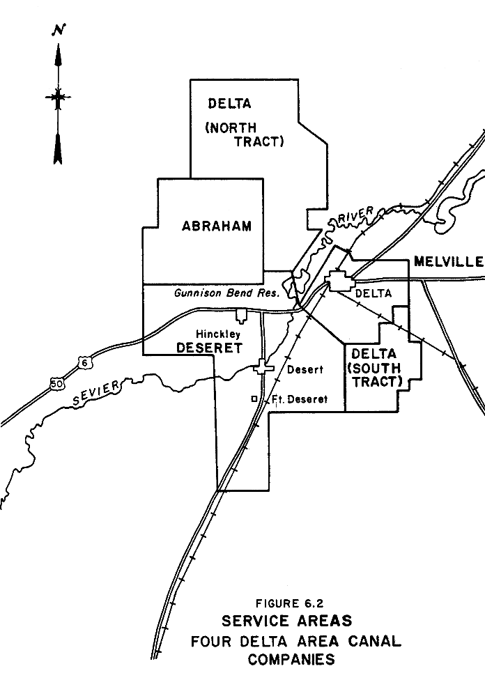
for development, most of the land was in the North Tract, located northwest across the river from the
Melville area (refer to Figure 6.2). The rest, the South Tract, was south of the Melville area. The
Oasis Land and Water Company thought they had a firm contract with the State of Utah for the right to
develop additional water sufficiently above that purchased to give a full irrigation right for the
43,000 acres. 
Figure 2.
| Click on the image for a larger version. |
Some water was turned into the Melville system in 1908. At the beginning of the 1909 irrigation
season one flume had been completed to deliver irrigation water to the Oasis project's North Tract.
The Carey Act segregation caused rapid growth in the Burtner (Delta) area for about ten years. Settlers
were arriving daily. The railhead at Burtner became a boomtown; for a short period of time the town was
a tent city. The first 15,000 acres offered were "snapped up," mostly by people from the Midwest. The project's initial diversion dam was earth-fill with concrete diversion and spillway structures.
The one unusual condition was that to put the water into the canal required a considerable back-up.
During the night of June 14, 1909, the spillway, constructed on sand, was undermined, leaving the canal
high and dry. The flood wave resulting from the dam failure reached Gunnison Bend Reservoir, washing
out the Cropper Cut. A regenerated flood wave went on down the river through Deseret causing considerable
damage. The John Avery Bishop account printed in the Millard County Chronicle, March 1911, chronicled the
event. One folktale told by "oldtimers" in Deseret serves to highlight one memorable event. A local
citizen of stature who was known to drink a little was on the roof of his chicken coop watching the
flood go by. As the saloon building collapsed he was heard to cry out "Oh my God! I'm ruined." The efforts to restore the diversion dam were frantic and heroic. E. L. Abbott (1949), an early
settler, wrote of the period: I will never forget the first few days at the dam site, where the people
had gathered to begin reconstruction. It was hoped, at first, that the dam could be replaced in time to
save the crops so the people came, men with their wives and children rushed to the scene. The men went
to work on preliminary work on the dam, leaving the women and larger children to set up the tents and
establish camp. Not all of them had tents, but used wagon covers and other materials to shelter them from
the blistering sun and elements; none of these, not even the tents were adequate to give them the proper
protection under the conditions, and there was considerable discomfort and even suffering. The first night will always remain a nightmare to me. After a grueling hot and busy day, night came
on with none of the camp fully established and most of their belongings still lying where they had been
unloaded from the wagons. The campfires were built, over which a meager supper was prepared and eaten. The
animals were taken care of for the night and folks went to work untangling their belongings and getting
ready to retire and get some rest through the night. The heat dust and flies had been a menace all day, but
at night there by the river, where the reservoir had been, the mosquitoes nearly devoured us. Babies and
small children were crying, mothers and older children trying to comfort them and get them tucked away in
the improvised beds on the ground. It was all heart sickening, and I wondered if it could be long endured. Some of them couldn't
endure it and in a few days pulled out for more pleasant places. Most of them, however, stayed and by
persistent and intelligent efforts improved the living conditions in the camp, and fought on determinedly,
until the dam was completely replaced, but not early enough to save any of the crops on the project
and there was but very little fall grain put in. Many of the people had planned on working on the canals and clearing more land that winter, but
the winter of 1909-1910 was a severe one, and there was no work done. Many of the people were quite hard
up by spring, but when spring finally came, they all went to work planting crops, working on canals and
many other things that had to be done to build a country. These activities, however, were soon brought to a halt, for again in the spring of 1910,
the dam went out. That year was almost a complete repetition of the year before. A few more people gave
up and left but for the most part, the same people that had so heroically fought it out the year before,
again went back and gave the Old Sevier a whipping . . .
After the second failure, it was decided that the canal head would be extended upstream
until it intersected the river channel. A new diversion dam was completed at this site in 1911.
The spillway structure served until 1960, at which time it was refurbished to be used as a drop
structure in conjunction with the new DMAD Dam located three-fourths of a mile upstream. The lawsuits and claims resulting from the two dam failures of 1909 and 1910 threw the Oasis
Land and Water Company into receivership. A corporation organized in Nevada, the Delta Land and
Water Company, took over the project. The money came from prominent Salt Lake City investors. The newly formed Delta company was able to get the project back on its feet. The State
Engineer (1913) described the formible list of features completed: The diversion canal has a capacity of 750 second-feet for the first
seven miles and carries water for both the Delta Land and Water Company and the Melville Irrigation
Company. When it emerges from the canyon it is divided, with one part, called the North Canal,
crossing Sevier River to irrigate lands on the right bank, and the other, called the South Canal,
continuing down the left side of the river. The North Canal crosses the river by means of two flumes; one built of steel and is about
10 feet in diameter, and the other is of wood and four feet deep by six feet wide. These flumes
are 600 feet long and rest on a trestle that is 35 feet above the bed of the river. Their combined
capacity is 300 second feet, all belonging to the Delta Land and Water Company. The total length
of this main canal is thirteen miles and it will irrigate lands lying five to ten miles northwest
of the new town of Delta on the San Pedro, Los Angeles and Salt Lake R.R. The other branch continued as an earthen canal down the left side of the river, with a
capacity of 450 second-feet for four miles when it divides, about 150 second-feet going to the
Melville Irrigation Company, and the remaining 300 second-feet goes into a canal of the Delta Land
and Water Company which has a length of about seven miles, not counting lateral, and irrigates
lands southeasterly of the town of Delta. The Delta project is the first of the Carey Act projects to be completed in Utah, and 30,00
acres of the 43,000 acres segregated have already been sold. It is estimated that 12,000 acres were
cropped in 1912. The old company sold 14,000 acres of land and water rights at $40 to $45 per acre,
with ten annual payments and six per cent interest on deferred payments. The Delta Land & Water
Company since taking over the project has sold 16,000 acres at $50, with twelve years to complete
payment, and six per cent interest on deferred payments. It has spent $150,000 for construction of
the new diversion dam, for canals and other betterments, and it is to spend about $30,000 more for
its share of the cost of increasing the storage capacity of the Sevier Bridge Reservoir. The sales
have been made to Utah people, to farmers from the Mississippi Valley, especially Oklahoma, and a
large amount to residents of southern California. The contracts for water calls for 1.5 acre-feet
per acre per annum measured at the point of delivery to the settler and within one half mile of each
quarter-section of land.
The Land RushThe land promotions of the Oasis Land and Water Company and its successor the Delta Land and
Water Company were typical of Utah land promotions. Although speculation in Delta was in water rather
than land, the methods used to attract settlers was basically the same as those used for other
speculative projects. Brochures were an important component. Since they were to be distributed in the
Midwest, the brochures were designed to touch a vital nerve. One of the short comings of our nation's
bread basket is that on occasion rainfall does not come at critical times. The almost ideal climate
and soil do not always deliver the maximum crop. What an opportunity to go where the missing ingredient
could be applied at will. That the soil and climate might not be ideal was glossed over. One brochure
explained the secret to the project's assured success: The secret of it all is virgin soil--inexhaustible in depth--and WATER,
no floods, no droughts; just a steady crop growing climate.
Although no orchards had been planted, the possibility of raising fruit was not overlooked.
"While no effort has yet been made to raise fruit around Burtner, apples, pears, and plums will
undoubtedly do well." Another crop, which was mentioned frequently in promotions, was alfalfa for seed. The brochures promised that settlers could expect to live the good life in Delta: The value of farm and farm products is increasing every year, and the
farmer has the most independent life of any class. He is the most contented, worries the least,
lives the best and most farmers in Utah have a bank account.
and: Now if you are a farmer Delta would give back to you
tenfold--yes, twentyfold--more than you put into it. But you must work! You must come with enough
to make a start--and that need not be much.
After making their claims, the Delta company challenged prospective buyers to come to Delta and look around: Farmers who drove out onto their land in prairie schooners
two years ago are today living in modest houses, their stock well covered. While around them
fields of rye, wheat, alfalfa, barley and oats are waving a promise of a third crop that will
put money in the bank for every man who has properly farmed!
All this in little more that a round of seasons! Does it seem possible? Does it seem probable? Come to Delta
and see for yourself. Drive over the land and talk with the men who have brought about this
transformation. Ask them what they'll sell for.
Potential settlers from the Midwest were given the hard sell. One of the early settlers
was Fred Baker from Illinois. Before buying, he visited the project. His wife described the impression Delta made
on her husband (Baker, undated}: The project was alive with activity, men from many states were
taking up land, and after only a day or two of looking it over, he decided on an 80 acres in
what was known as the South Tract. He returned with fabulous tales of the wonderful climate,
the soil, "just like an ash bank" (under the greasewoods), the vast stretches of alfalfa
fields. They took him through Oasis and Deseret--and best of all, "no waiting for rain."
As a man from Illinois, it not difficult to see why he was favorably impressed with the
Delta area. Baker lived in an area where the rain did not always come at the right time to properly
mature crops. In Delta, he would not have to wait for water, but merely open a headgate and let
water pour over the land. The difference between what was promised in brochures and during tours, and the
eventual reality in Delta, left Mrs. Baker bitter: "Nothing of course was said about the wind,
the dust, the periodic drouths, the unyielding soil, the alkali and numerous other disadvantages,
but then they were salesmen." And perhaps she had a right to be bitter. Folktales abound of
questionable sales practices. Fred Rock, one of the early settlers in the North Tract, had some of the area's only trees.
Agents of the Delta Land and Water Company would intimate that the country would produce fruit. As
they zipped past Fred Rock's place prospective buyers could observe some nice looking apples on
one of his trees. The tree was probably a small poplar. Rock had been hired to keep the fresh apples
tied to his tree. Another "oldtimer," Bill Bassett described some creative photography in grain field.
He had seen a great deal of activity there. The barley patch was a little less than typical,
about one foot high, thin and struggling, but not so unusual, as most farmers had experienced a
similar crop. However, it had headed out. His horses needed a rest and being curious he tied
the team to the fence and walked out into the field to see what was going on. A group consisting
of three men digging a hole, a farmer, and a photographer. When the hole was deep enough, the
farmer jumped in the hole and the photographer took some nice photos showing barley reaching
to the farmer's nose. Enlargement of Sevier Bridge ReservoirAs already noted, several projects had a need for upstream storage. The Sevier Land and
Water Company, a new venture formed to develop and irrigate lands in eastern Pahvant Valley,
was considering a site which would have backed up water to the toe of Sevier Bridge Reservoir.
The owners of the "Hawley Filing" were considering an enlargement of Sevier Bridge Reservoir to
impound their full water right. To further complicate matters, three individuals filed an application for a proposed
damsite at Painted Rocks, northwest of Fayette. The location of this latter would have precluded
any enlargement of Sevier Bridge Reservoir. This latter filing was ultimately transferred to the
Sevier Land and Water Company and the company settled on this filing for its proposed project. Litigation followed between the Sevier Land and Water Company and the Delta, Melville, and
Deseret companies. Realizing the futility of litigation, the four companies entered into
negotiations. With an agreement near, the Sevier Land and Water Company filed water rights
application #4562. On April 9, 1913 a "Four Party Contract" was signed by Delta Land and Water
Company, Sevier Land and Water Company, Deseret Irrigation Company, and the Melville Irrigation
Company. This contract gave a "first, absolute, unquestioned, prior and preferred right to all
waters which are now or may be impounded in said reservoir up to the capacity above mentioned"
to the Delta Land and Water Company (1/2), Melville Irrigation Company (1/3), and the Deseret
Irrigation Company (1/6). The enlarged capacity was then divided as follows: Table 2. | Sevier Land and Water Company | 41% | | Deseret Irrigation Company | 26% | | Delta Land and Water Company | 17% | | Melville Irrigation Company | 16% |
Plans were submitted for the enlargement of Sevier Bridge Reservoir to the State Engineer
in the Fall of 1912. After being returned several times for modification, these plans were finally
approved a year later. The approved plans called for a structure 90 feet in height and with a
positive cutoff. This latter feature was to rectify some problems with the existing dam. The
conclusions of one consulting engineer were (Utah Division of Water Rights, 1979): The results to be achieved in the way of water storage will be greater
for the money expended than any other storage reservoir project in the West. The cost need not exceed
seventy-five cents per acre-foot of reservoir capacity, which is far below the average of Western
reservoirs.
He concluded the dam height could be increased by 20 feet and proposed a design consistent with
the "state of the art" in 1911. The addition to the embankment in 1916 was keyed into the old
embankment using a series of steps constructed on both the upstream and downstream faces. Seepage was
a problem with the old dam and, consequently, a combination sheet metal, sheet pile, and concrete cutoff
wall was constructed to prevent stored water from moving under the dam The State Engineer (1915)
described the difficulties with the damsite: While the reservoir site is an ideal one, the damsite is a poor one, on
account of a lack of suitable foundation. It will require careful and conservative engineering to
enlarge this structure to a height of 90 feet and make it safe.
Despite the difficulties associated with the damsite, the dam was successfully enlarged. The
design consisted of relatively flat outer slopes and a 26 foot wide crest. The fill was placed using
hydraulic fill methods, that is monitors were used in the borrow area to wash soil laden water down a
flume to the embankment where the water was ponded and the sediments allowed to settle out. This was
Utah's largest effort at constructing a dam using hydraulic methods. The work was completed June 17, 1916.
Most of the work was done by stockholders of the Deseret Irrigation, Melville Irrigation, Delta Land
and Water, and the Sevier River Land and Water Companies under the direction of various consulting
engineers. The enlarged reservoir which stands today has a capacity of 236,0000 acre-feet, one of Utah's
larger storage reservoirs. While Yuba Dam was being constructed, negotiations on water rights continued resulting in
following ownership agreement: Table 3. | Up to 104,000 acre-feet: | | | | | Delta Canal Company | 50% | | | Melville Irr. Co. | 28 1/3% | | | Deseret Irr. Co. | 16 2/3% | | | Central Utah (heir to Sevier Land and Water) | 5% | | Over 104,000 acre-feet: | | | | | Central Utah | 57% | | | Delta Canal Company | 17% | | | Deseret Irrigation Company | 20.55% | | | Abraham Irrigation Company | 5.45% |
Avery and Singer (1982) in their history of Utah water developments, appear to have confused
the effort to enlarge Sevier Bridge Reservoir with DMAD Reservoir. Because of the relatively late
construction date of DMAD, it seems likely that Avery and Singer (p. 30) are referring to the efforts
to enlarge Sevier Bridge Reservoir: Aided by Federal reclamation funds, these companies built several
small dams on the Sevier River, including the Gunnison Bend and D.M.A.D. reservoirs. The D.M.A.D.
is among the most interesting because stockholders of Deseret, Abraham, and Melville Irrigation
Companies joined the Delta Irrigation Company to build the dam, a precursor to water management in
other areas of Utah during the 20th century.
It should be noted that Sevier Bridge Reservoir is by no means a "small dam. and was in no
way aided by Federal reclamation funds. It does, however, represent a "precursor to water management
in other areas of Utah during the 20th century DrainageThe prospect of rich irrigated valleys turning into salty deserts or marshes, like the once
productive plains of the Tigris and Euphrates valleys of ancient Mesopotamia, did not concern the
developers of the Delta Carey Act project. The early settlers of the Deseret and Abraham districts
were aware of water table problems on the low-lying, tight-clay soils on the western fringe of the
irrigated area. Most of the early developed land, however, lay in close proximity to the river. These
soils are generally of Oasis loam which are quite permeable, and the river channel provided good
drainage. Crop production in these areas had always been high. The river channel unfortunately gave
adequate drainage to only a small percentage of the Pahvant valley. The wet years commencing in 1906
brought a large increase in irrigated acreage, much of which did not have natural drainage. By 1909, the Deseret Irrigation Company had asked the U.S. Department of Agriculture to survey
and plan a systematic drainage system. A report was presented to the stockholders of the Deseret
Irrigation Company on July 30, 1910. It was recommended that open drains be dug one-half mile apart
and five to six feet deep. The alternative would be the abandonment of some of the lands. The only
drainage activity over the next few years was by the Deseret Irrigation Company. Even after lands became waterlogged, it was difficult convincing farmers of the need for
drains. Many felt that with drains in place that nutrients would be removed with the drainage water.
It was decided that a public information program was necessary. The U.S. Department of Agriculture,
in cooperation with Utah State Agricultural College, conducted an active educational program for
nearly eight years before four drainage districts were finally formed. when county commissioners,
boards of supervisors, irrigation companies, and the more prominent farmers all urgently recommended
drainage, success was assured. M. A. Abbott of Sutherland was appointed as one of the first three men on the board of
supervisors for Drainage District No.3. Mr. Abbott's account would probably be a representative view. Our high hopes for good times and big crops were soon to be shattered.
We were using large quantities of irrigation water and in 1917 there were several places indicating
water-logging with a strong content of alkali on the surface which prevented germination of seed and
killed established plants. This condition spread rapidly and by 1918 we all knew something must be
done or else everybody would be financially ruined and would have to move away.
In Mr. Abbott's personal history there was another very significant statement. By 1920 we had fully demonstrated that the lands could be drained and
reclaimed. But the dense growth of tumbleweeds and thistles and other weeds during the water-logged
period were a great nuisance to us, blowing around and filling up our open drains and open trenches.
Because of the problems with open drains, it was decided to use a system of closed drains.
The only open drains were those serving as collectors for the tile drainage system. Over the next eight years nearly three million dollars was spent installing a drainage system
for some eighty thousand acres of land. This money was nearly all raised by selling bonds which
obligated every farmer in the districts to repay the costs of drainage at a unit cost per acre of
the lands benefited. Much hindsight analysis has indicated reasons for the failure of this expensive project.
Most of the drainage was by tile lines laid from six to seven feet deep and then back-filled.
Unfortunately, the tile used was simply straight sections butted together with no structural
shapes to form joints and no enveloping material to stabilize the alignment. The end space
between sections provided the inlet to the tile line for the excess groundwater. The drought of the 1930s brought more problems than could be solved. Having been constructed
with inflated dollars, the repayment was being made with deflated depression dollars. Instead of
80,000 producing acres, there was a water supply barely sufficient for 35,000. In addition, many
farmers now believed the drains were taking away needed water and nutrients. There were many instances
of the drains being blocked, and to this writer's personal knowledge dead animals were put into
inspection boxes to prevent cleaning or observation. This time of stress resulted in two very important events. The deficient water supply was
further aggravated by the water rights structure. For example, the operating procedure of Sevier
Bridge Reservoir required that at the beginning of each irrigation season the stored water was
allocated as to the first 104,000 acre-feet allocation provided in the "Four Party Contract" and
other decrees. Thus, those irrigation companies with direct flow, or primary water in Sevier Bridge
Reservoir either used it or lost it to the storage companies. As a result some canals ran water all
winter simply because the companies did not want to lose their water to another company. This
wasteful practice could not be tolerated by pioneers who had worked so hard for their projects.
These conditions led to what is known as the "1938 Agreement" which allowed each and every user to
hold over any unused credits. The allocation between piute and Sevier Bridge as well as between the
various companies would be based on the new water accruing after October 1 of each year. This
agreement made it possible for Piute, Sevier Bridge, and Otter Creek Reservoirs to become long
term carry-over reservoirs. The result was a much more efficient use of the Sevier River for
irrigation. The second major event resulted from the depressed economy. Most farmers had difficulty
paying their taxes. As the law required, Millard County sold the delinquent tax lands for back
taxes. After going through the court system, the U.S. Supreme Court ruled that the county could
sell and deliver a clear title with a tax deed. Many landowners advocated allowing the taxes to
become delinquent thus relieving the drainage bond obligation. Others disapproved of this procedure,
considering it little more than a device to cheat the bondholders. Much of the farm land became tax
delinquent, was sold, and title acquired by tax deed. The important fact, however, was that the
drainage lien did not last forever on land that could not pay. Ultimatelya settlement with the
bondholders was made by those who did not let their land be sold for taxes. Some lands were redeemed
by the bondholders for back taxes and later sold to farmers. Thus, the indebtedness incurred to
construct the drainage system was eventually all retired. An adequate water supply returned in the 1940s. AS the drainage system now became important,
it began to fail. As the water table rose, it created a "head" at the seam where two tile sections
came together. The high water velocities moved the fine material and when a large enough cavity was
created a section of tile would drop to a vertical alignment thereby plugging the drain. The drainage
district board, consisting of appointed farmers, reacted promptly and effectively to this crisis.
Dragline excavators were purchased and the open drain system which now exists was started. The Utah Agricultural Experiment Station Bulletin (Israelson, 1935) gives a comprehensive
detailed account of the history and drainage conditions as of 1935. However, water quality, one
of the most important considerations affecting drainage was not even mentioned. The salinity of
the lower Sevier River increased with the development of the upper basin. Before reservoir
construction, salinity was only a problem in the late irrigation season. After the reservoir system
was completed, and particularly after the 1938 Agreement, return flows constituted a significant
amount of water diverted in some sections of the Sevier River. For example, in a dry year when the
only water available to the lower Sevier River is from return flows, the water contains high levels
of salt. High levels of salinity in irrigation water can be injurious to crops. It is the water
moving from the upper Basin to Sevier Bridge that keeps the water quality viable. When the administration
of water rights is such that the return flows are more than a small part of the diversion available,
disaster results. A fact not understood in early drainage efforts is that the salinity of the Sevier
River at Delta is such that if applied to tight soils without adequate drainage, the land is rendered
useless by salt in about three years. ConclusionsAvery and Singer (1982) correctly note that the Deseret and Abraham developments were fostered
by the cooperative spirit infused in the area by the Mormon Church. However, in general, the role
of the church in getting the Pahvant Valley settled is exaggerated. To quote Arrington (1951, p. 393): While the founding of these settlements was not the result of a
direct "call" from general authorities of the Mormon Church, as was true of many Great Basin
colonies, their successful establishment proved to be impossible without extensive
organizational and financial assistance from the Mormon Church.
While the Mormon Church was certainly at times at least very interested in Pahvant Valley,
it was not the church per se which kept the developments going, it was the grit of the local
settlers. The organizational role of the local Mormon community was important; the financial
role of the Mormon Church was less so. While the above arguments may be semantic in nature, the alleged role of the Federal
government is not. Avery and Singer state that the Delta and Melville projects "relied on
Federal reclamation funds to construct their water systems, which reflects the crucial role
Federal policies played in the 20th century." This is not true. While the Federal Carey Act was the inspiration behind the Delta
project, it was not the financial support. The capital to build the project was raised from
private individuals; the "spunk" to keep the project going was provided by the settlers
themselves. Avery and Singer continue: "The unique cooperation between the early Mormon
companies, and the later canal companies is a valuable case study as it foreshadowed other,
similar arrangements in Utah." Cooperation began with the joint facilities of the Abraham
(a church inspired project) and the Deseret Gunnison Bend project. Delta and Melville,
privately owned and operated irrigation companies, also cooperated to share a diversion dam
and canal system. But the real cooperative effort began with the enlarging of Sevier Bridge
Reservoir. Furthermore, the enlargement of Sevier Bridge was not a Federal Project and not a
State project; it was a development by and for the local people, who, strapped for finances,
did much of the work themselves. Dudley Crafts (1965) in a discussion at a special water
development meeting of the Millard Water Conservancy District stated: Except for the land leveling and some canal improvements which
taken place in the last few years, our entire development has been through private enterprise
without the assistance of any governmental agency whatsoever.
The Delta Carey Act project ultimately developed approximately 30% of the Delta area
agriculture. There are three primary reasons why this project succeeded where other Carey Act
projects failed. First and most importantly, the Oasis Land and Water Company bought a basic,
prior water right. Second, the developers were private investors who started with the hopes of
making substantial profits. The tenacity of good businessmen determined to protect their
investments was an important factor in staying the course. Finally the third reason, the
settlers demonstrated a great deal of tenacity of their own during some very difficult times.
Such will to succeed assured the successful development of water resources in the Delta area. ReferencesAbbott, Edward Lawrance. 1949. History of Sutherland Ward and District.
Typed copy in possession of author. Abbott Family. 1975 (revised in 1978). Myron and Alma Abbott and Mary
Matilda Leavitt Family. unpublished, copy in possession of author. Arrington, Leonard J. 1951. Taming of the Turbulent Sevier: A Story of the Mormon Desert Conquest.
Western Humanities Review (26:1) University of Utah, Salt Lake City, Utah. Baker, Gertrude (Kendall). undated. Cross Currents, A Family Chronicle.
Typescript copy in the files of the Utah Historical Society, Salt Lake City, Utah. Crafts, Dudley. 1976. History of the Sevier Bridge Reservoir.
Du Wil Publishing Company. Delta, Utah. Crafts, Dudley. undated. Typewritten notes in the possession of Thorpe Waddingham. Daughters of the Utah Pioneers. 1951. Milestones of Millard.
Art City Publishing Company, Springville, Utah. Israelsen, 0. W. 1935. Drainage and Irrigation, Soil, Economic and Social Conditions,
Delta Area. Utah Agricultural Experiment Station Bulletin 225, Utah State Agricultural College,
Logan, Utah, April. Jensen, William R. 1971. Canals and Canards: Three Case Studies and Water Speculations in Utah,
1905-1920. M.A. Thesis. Department of History, Utah State University, Logan, Utah. King, Volney. 1947. Millard County, 1851-1875. Utah Humanities Review, I. Millard County Chronicle. 1911. "Delta Land and Water Company" and "Resources of Millard County,"
March 23 as reprinted in the 1971 Anniversary Edition of the Millard County Chronicle. Reeve, R. C. 1948. Reclamation of Saline-Alkali Soils by Leaching: Delta, Utah.
Utah State Agricultural Experiment Station Bulletin 335, Logan, Utah. State Engineer. 1913. Eighth Biennial Report to the Governor of Utah: 1912-1913.
The Arrow Press, Salt Lake City, Utah. State Engineer. 1915. Ninth Biennial Report to the Governor of Utah: 1914-1915.
The Arrow Press, Salt Lake City, Utah. Thomas, George. 1920. The Development of Institutions Under Irrigation: With Special
Reference to Early Utah Conditions, The MacMillan Company, New York. Utah Division of Water Rights. 1979. Phase I Inspection Report: Sevier Bridge
Reservoir, for the Department of the Army, Corps of Engineers, Sacramento Division, January. Walker, W. Roger and Wynn R. Walker. 1972. "Surviving with Salinity in the Lower
Sevier River Basin," in Managing Irrigated Agriculture to Improve Water Quality,
proceedings of the National Conference.
|
|
|